Maps of Great Nicobar

Koetaradja / Survey of India
Survey of India [S.l.] : Survey of India
Sabang & Nicobar Islands
Topografische Dienst Batavia Batavia : Topografische Dienst
Nikobarische Inseln
Nikobary (Indie) Zhischman, A. E. k.k. geographische Gesellschaft
Karte der Nikobarischen Inseln
Nikobary (Indie) Wüllerstorf-Urbair, Bernhard von F. Köke
Meulingge / prepared under the direction of the Chief of Engineers U.S. Army by the Army Map Service
Army Map Service U.S. Army Washington D.C. Washington D.C. : Army Map Service
[P[oelau] Breueh of Lam Poejang] / [Topographisch Bureau]
Topographisch Bureau Batavia [Batavia : Topographisch Bureau]
Burma und Malayische Halbinsel
1 : 6000000 Malajsie
Indonesia, Thailand and Malaya. Pergamon World Atlas.
1 : 5000000 Polish Army Topography Service

[Overzichtskaart van den Oost-Indischen Archipel]. Bl. I
1 : 2500000 Annotatie: Overige bladen (II-VI) ontbreken [Batavia : Topographische Inrichting]
Isthme de Kraw. Asie 109.
1 : 1641836 Vandermaelen, Philippe, 1795-1869
Partie, Sumatra. Oceanique no. 11.
1 : 1641836 Vandermaelen, Philippe, 1795-1869
Partie, l'Empire Birman. Asie 104.
1 : 1641836 Vandermaelen, Philippe, 1795-1869
Die britische Provinz Pegu und der südliche Theil von Barma
1 : 3000000 Myanma Kiepert, Heinrich Yule, H. D. Reimer
[Nasi-Ketjil] / [Topographisch Bureau]
Topographisch Bureau Batavia [Batavia : Topographisch Bureau]
131-132. Indochina. The World Atlas.
1 : 5000000 USSR (Union of Soviet Socialist Republics).
Siam, Burma & Anam.
1 : 6969600 Stanford, Edward
HINTERINDIEN
1 : 4000000 Kambodža Berghaus, Heinrich Karl Wilhelm Brose, W. Justus Perthes
Burman Empire
A new general atlas of modern geography, consisting of a complete collection of maps of the four quarters of the globe Wyld, James James Wyld
Hinter Indien.
1 : 9400000 Radefeld, Carl Christian Franz, 1788-1874
Birman Empire & Countries South East of the Ganges.
1 : 7650000 Teesdale, Henry
Neueste Karte von Hinter Indien
Grosser Hand-Atlas über alle Theile der Erde in 170 Karten Meyer, J. Verlag des Bibliographischen Instituts
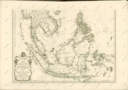
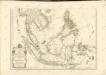
Carte Generale des Indies.
1 : 9500000 Vivien de St Martin, L.
India South.
1 : 5448960 Stanford, Edward
Hind, Hindoostan or India
A new general atlas of modern geography, consisting of a complete collection of maps of the four quarters of the globe Wyld, James James Wyld
Hind, Hindoostan, or India.
1 : 5650000 Faden, William, 1750?-1836
Charte von Ostindien jenseits des Ganges
Zadní Indie
CHARTE von OSTINDIEN Jenseits des Ganges
Ganga-oblast (Indie a Bangladéš)