Maps of Opole Voivodeship

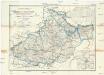
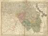
Dvcatvs Silesiae tabvla altera Svperiorem Silesiam
1 : 610000 Horní Slezsko Hase, Johann Matthias Homannianos Heredes
Dvcatvs Silesiae tabvla altera Svperiorem Silesiam exhibens
1 : 610000 Horní Slezsko Hase, Johann Matthias per Homannianos Heredes
Dvcatvs Silesiae tabvla altera Svperiorem Silesiam
1 : 610000 Horní Slezsko Hase, Johann Matthias Homannianos Heredes
Dvcatvs Silesiae tabvla altera Svperiorem Silesiam
1 : 610000 Horní Slezsko Hase, Johann Matthias Homannianos Heredes
Dvcatvs Silesiae tabvla altera Svperiorem Silesiam
1 : 610000 Horní Slezsko Hase, Johann Matthias per Homan[n]ianos Heredes
Dvcatvs Silesiae tabvla altera Svperiorem Silesiam
1 : 610000 Horní Slezsko Hase, Johann Matthias per Homan[n]ianos Heredes
Dvcatvs Silesiae Tabvla Altera Svperiorem Silesiam -
1 : 580000 Mollova mapová sbírka Hase, Johann Matthias Homann, Johann Baptista - dědici
Dvcatvs Silesiae Tabvla Altera Svperiorem Silesiam
1 : 585000 Mollova mapová sbírka Homann, Johann Baptista - dědici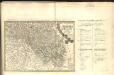
Dvcatvs Silesiae Tabvla Altera Svperiorem Silesiam =
1 : 575000 Mollova mapová sbírka Hase, Johann Matthias Homann, Johann Baptista - dědici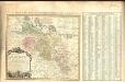
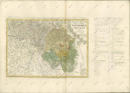
Amplissimi Episcopatvs Wratislaviensis primum in suos IV Archidiaconatus deinde in Circulos Archipresbyteriales divisi Tabula Geographica :
1 : 730000 Mollova mapová sbírka Felbiger, Johann Ignaz Homann, Johann Baptista - dědici
Československá republika země Česká a Moravskoslezská

Sheet III: Karte Des Oesterreichischen Kaiserstaates.
1 : 576000 Scheda, Josef
III, uit: General-Karte des oesterreichischen Kaiserstaates mit einem grossen Theile der angrenzenden Länder / durch Josef Scheda ... bearb. und hrsg
1 : 576000 Annotatie geografische gegevens: Maatstokken: oesterreichische Meilen, geografische oder deutsche Meilen, preussische Meilen, türkische Berri, französische Lieues, russische Werste; Maatstok per blad: wiener Klafter, öster. Meilen; Blad XIX: statistische en taalkundige informatie; Blad XIX: legenda [Wien : K.K. Militärisch-Geografisches Institut]
Silesia.
1 : 1700000 Bowen, Frances
Partie meridionale de la Silesie
1 : 408000 Mollova mapová sbírka Le Rouge, Georges-Louis Le Rouge, Georges-Louis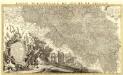
Partie Meridionale du Duché de Silesie /
1 : 400800 Mollova mapová sbírka Covens, Johannes Condet, Johannes Covens, Johannes I
Das souveraine Hertzogthum Ober- und Nieder- Schlesien, nebst der souverainen Grafschaft Glatz
1 : 1100000 Mollova mapová sbírka Schleuen, Johann David Schleuen, Johann David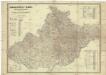
Die Markgrafschaft Maehren mit dem Herzogthume Schlesien
1 : 200000 Morava (Česko) Schenkl, Conrad Philipp Verlag von Carl Winiker
Příruční mapa Markrabství moravského a Vévodství slezského
1 : 450000 Brno-oblast (Česko) Wagner, Jan Eduard F. Kytka
Höhenschichten-Karte von Mähren und Ö. Schlesien
1 : 432000 Morava (Česko) Kořistka, Karel František Edvard Eduard Hölzel
Höhenschichten-Karte von Mähren und Ö. Schlesien
1 : 432000 Morava (Česko) Kořistka, Karel František Edvard Eduard Hölzel
Katastrální mapa pro obec Otradov
1 : 2880
Grossdeutsches Reich Sudetenländer

Das Hertzogthum Schlesien mit seinen abgetheilten Fürstenthümern und Herrschafften
1 : 2200000 Mollova mapová sbírka Weigel, Christoph Weigel, Christoph I.
Das souveraine Hertzhogthum Ober- und Nieder-Schlesien nebst den souverainen Grafschaft Glatz, wie solches nach dem Friedens Tractact d. 28. Jüly 1742 an Sc. Königl. Maj. von Preussen von der Königin von Ungarn Maj. auf ewig abgetreten worden
Horní Slezsko Le Rouge, Georges-Louis Schleuen, Johann David Schleuen
Strassen Karte der Margrafschaft Maehren und des Herzogthums Schlesien
1 : 432000 Morava (Česko)
Silesiae dvcatvs
1 : 1050000 Mollova mapová sbírka Scultetus, Johannes Danckerts, Cornelis