Maps of Sudetes Mountains

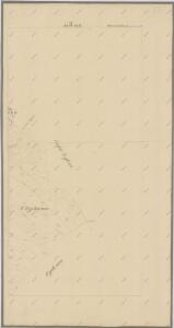
Katastrální mapa pro obec Otradov
1 : 2880
III, uit: General-Karte des oesterreichischen Kaiserstaates mit einem grossen Theile der angrenzenden Länder / durch Josef Scheda ... bearb. und hrsg
1 : 576000 Annotatie geografische gegevens: Maatstokken: oesterreichische Meilen, geografische oder deutsche Meilen, preussische Meilen, türkische Berri, französische Lieues, russische Werste; Maatstok per blad: wiener Klafter, öster. Meilen; Blad XIX: statistische en taalkundige informatie; Blad XIX: legenda [Wien : K.K. Militärisch-Geografisches Institut]
Sheet III: Karte Des Oesterreichischen Kaiserstaates.
1 : 576000 Scheda, Josef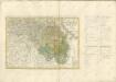
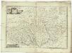
Die Markgrafschaft Maehren mit dem Herzogthume Schlesien
1 : 200000 Morava (Česko) Schenkl, Conrad Philipp Verlag von Carl Winiker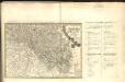
Dvcatvs Silesiae Tabvla Altera Svperiorem Silesiam =
1 : 575000 Mollova mapová sbírka Hase, Johann Matthias Homann, Johann Baptista - dědici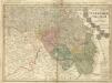
Dvcatvs Silesiae Tabvla Altera Svperiorem Silesiam -
1 : 580000 Mollova mapová sbírka Hase, Johann Matthias Homann, Johann Baptista - dědici
Dvcatvs Silesiae tabvla altera Svperiorem Silesiam
1 : 610000 Horní Slezsko Hase, Johann Matthias Homannianos Heredes
Dvcatvs Silesiae tabvla altera Svperiorem Silesiam exhibens
1 : 610000 Horní Slezsko Hase, Johann Matthias per Homannianos Heredes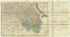
Dvcatvs Silesiae tabvla altera Svperiorem Silesiam
1 : 610000 Horní Slezsko Hase, Johann Matthias Homannianos Heredes
Dvcatvs Silesiae tabvla altera Svperiorem Silesiam
1 : 610000 Horní Slezsko Hase, Johann Matthias Homannianos Heredes
Dvcatvs Silesiae tabvla altera Svperiorem Silesiam
1 : 610000 Horní Slezsko Hase, Johann Matthias per Homan[n]ianos Heredes
Dvcatvs Silesiae tabvla altera Svperiorem Silesiam
1 : 610000 Horní Slezsko Hase, Johann Matthias per Homan[n]ianos Heredes
Dvcatvs Silesiae Tabvla Altera Svperiorem Silesiam
1 : 585000 Mollova mapová sbírka Homann, Johann Baptista - dědici
Partie meridionale de la Silesie
1 : 408000 Mollova mapová sbírka Le Rouge, Georges-Louis Le Rouge, Georges-Louis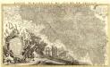
Partie Meridionale du Duché de Silesie /
1 : 400800 Mollova mapová sbírka Covens, Johannes Condet, Johannes Covens, Johannes I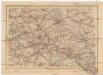
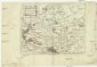
Deutsches Reich und Tschecho-Slowakei
1 : 600000 Morava (Česko) Koch, Wilhelm Opitz, Carl Arnd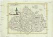
La Moravia divisa ne suoi circoli di nuova projezione
1 : 550000 Morava (Česko) Pitteri, Marco Alvise Antonio Zatta
Karte der Holzartenverbreitung in Protektorat Böhmen und Mähren
Svoboda, Pravdomil
Netz der trigonometrischen Vermessung der Gegend um Neuschloss
Nové Hrady (Ústí nad Orlicí, Česko)
Mapa lesů podle dřevin v protektorátě Čechy a Morava

[Dvcatvs Silesiae tabvla altera Svperiorem Silesiam]
Horní Slezsko Hase, Johann Matthias ar les Heritie[rs de Homann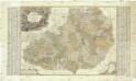
Tabula almae diocesis amplissimi episcopatvs Olomucensis in 32 decanatus divisae complectens omnes ejusden parochias et capellanatus locales una cum locis singulis cuilibet parocho quoad curam animarum subjectis
1 : 180000 Morava (Česko) Freyenfels, Johann Wenzl Xaver Frey von Hamilton, Maximilian von Homannianos Heredes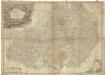
Die Markgrafschaft Mähren nebst dem Herzogthum Schlesien
1 : 750000 Lázně Jeseník (Česko) Berghaus, Heinrich Karl Wilhelm Berghaus, Hermann Justus Perthes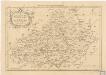
An accurate Map of the Marquisate of Moravia
Moravia
1 : 931000 Morava (Česko) Keere, Pieter van den
Carte Particuliere de la Moravie divisée en six cercles
1 : 650000 Mollova mapová sbírka Le Rouge, Georges-Louis Le Rouge, Georges-Louis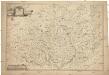
Das Markgraftum Maehren mit der Aelteren und im Jahr 1783 abgeaenderten Eintheilung der Kreisen, auch Bezeichnung der Granze der Olmütz Dioeces in Schlesien
1 : 322000 Morava (Česko) Venuto, Jan Antonín Engelmann, J. W.