Maps of Metropolitan France

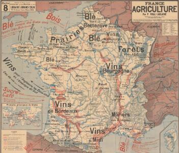
France Agriculture
Vidal de La Blache, Paul
Carte physique et routiere de la France, de la Suisse.
1 : 2000000 Brue, Adrien Hubert, 1786-1832
Carte de la France
1 : 3200000 Francie Poirson Jean M.d d'Estampes
France divisions militaires
Vidal de La Blache, Paul
France Industrie et commerce
Vidal de La Blache, Paul

France Villes
Vidal de La Blache, Paul
Composite: Frankreich in 4 Blattern.
1 : 1500000 Vogel, C.
Nieuwe kaart van Vrankrijk, volgens de nieuwste waarnemingen van de Koningl. Parijsche Academie
1 : 5750000 [S.l.] : [s.n.]
Regni Galliae seu Franciae et Navarrae...

Les routes exactes des postes du Royaume de France
1 : 2600000 Aug. Vindel. : Matth. Seutter excud.
France, in Departments.
1 : 4500000 Finley, Anthony
Frankreich
1 : 541000 Francie Schönfelder, F. Edl. von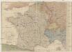
Karte von Frankreich
1 : 2056000 Francie Mollo, Tranquillo T. Mollo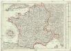
Karte von Frankreich
1 : 2056000 Francie Müller, Franz T. Mollo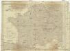
Karte von Frankreich
1 : 2060000 Francie Mollo, Tranquillo T. Mollo und Comp.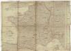
Karte von Frankreich
1 : 2060000 Francie Mollo, Tranquillo T. Mollo und Comp.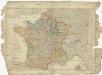
Karte von Frankreich
1 : 2060000 Francie Mollo, Tranquillo T. Mollo und Comp.
France Physique.
1 : 2500000 Vivien St Martin, L.
France cours d'eau
Vidal de La Blache, Paul
A new map of France, in which the post stages are exactly express'd
1 Karte : Kupferdruck ; 46 x 57 cm Rocque; Kitchin s.n.
64-65. France. The World Atlas.
1 : 2500000 USSR (Union of Soviet Socialist Republics).
Frankreich
1 : 3640000 Francie Mollo, Florian Florian Mollo
Frankreich
1 : 3640000 Francie Florian Mollo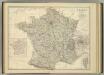
France in Departments.
1 : 2232000 Johnston, Alexander Keith
Karte von Frankreich
1 : 4260000 Francie Amon, Anton J. Riedls Kunsthandlung
Karte von Frankreich
1 : 4260000 Francie Amon, Anton J. Riedls Kunsthandlung
France en 1789.
1 : 3000000 Levasseur, E.
France Chemins de Fer Principales lignes de navigation
Vidal de La Blache, Paul