Maps of Papua

[Berai-Wara]
[S.l. : s.n.]
Geelvinkbaai / U.S. Army Map Service
U.S. Army Map Service Washington D.C. Washington D.C. : U.S. Army Map Service
Bladwijzer van Eilanden Biak-Japen en Kuststrook Verkam-Hollandia
[S.l. : s.n.]
Geelvink-baai / samengesteld en gedrukt bij den Topografischen Dienst
Topografische Dienst Batavia Batavia : Topografische Dienst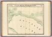
Partie, Nouvelle Guinee. Oceanique no. 23.
1 : 1641836 Vandermaelen, Philippe, 1795-1869
Nederlands Nieuw-Guinea / [Netherlands Topographic Service]
Netherlands Topographic Service Delft [Delft : Netherlands Topographic Service]
Nederlandsch-Nieuw-Guinee
Topographische Inrichting Batavia Batavia : Top[ographische] Inr[ichting]
Kaart van Nederlandsch Nieuw-Guinea en omliggende eilanden / Topographisch Bureau
Topographisch Bureau Batavia Batavia : Topographisch Bureau
Západní Irian

Overzichtskaart van de Residentie Amboina en de Afdeeling Noord-Nieuw Guinea / samengesteld door het Encyclopaedisch Bureau [in] 1915
Encyclopaedisch Bureau Batavia Batavia : G. Kolff & Co.
New Britain discoveries.
1 : 4500000 Hawkesworth, John, 1715?-1773
Carte des iles Moluques
1 : 3425000 par P. Melvill de Carnbee gravé par D. Heyse La Haye : lith de Ch. van Lier
[Schetskaart van Nieuw-Guinea] / Topografische Dienst
Topografische Dienst Batavia Batavia : Reproductiebedrijf Topografische Dienst
[Nieuw Guinea] / Topografische Dienst
Topografische Dienst Batavia Batavia : Reproductiebedrijf Topografische Dienst
Elf kaarten van Nieuw-Guinea / Directie Ned[erlands] Nieuw Guinea, Ministerie van Binnenlandse Zaken
Ministerie van Binnenlandse Zaken 's-Gravenhage . Directie Nederlands Nieuw Guinea ['s-Gravenhage : Staatsdrukkerij]
Schetskaart van Nieuw-Guinea / Topografische Dienst
Topografische Dienst Batavia Batavia : Reproductiebedrijf Topografische Dienst
Vegetatiekaart van Nieuw-Guinea
Topografische Dienst Delft Delft : Topografische Dienst
Schetskaart van Nieuw Guinea / Topografische Dienst
Topografische Dienst Batavia Batavia : Reproductiebedrijf Topografische Dienst
Nieuw Guinea / Topografische Dienst
Topografische Dienst Batavia Batavia : Reproductiebedrijf Topografische Dienst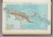
335. New Guinea, Solomon Islands. The World Atlas.
1 : 7500000 USSR (Union of Soviet Socialist Republics).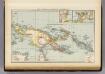
New Guinea, Papuan Archipelago.
1 : 10000000 Andree, Richard; Times (London, England)
Indonesia
IPPRESS Djakarta [Djakarta] : IPPRESS
Indonesië : voorlopige staatkundige ordening, bijgewerkt tot 1 october 1949
[S.l. : s.n.]
Koninlijke Paketvaart Maatschappij : in verbinding met de stoomschepen der stoomvaart maatschappijen 'Nederland' en 'Rotterdamsche Lloyd' naar een van de onderstaande havens in den Oost-Indischen Archipel / [Koninlijke Paketvaart Maatschappij]
Koninklijke Paketvaart Maatschappij (KPM) [S.l.] : Koninlijke Paketvaart Maatschappij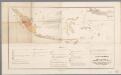
[LL.03791gk: 326/od/1914], uit: Overzichtskaart aangevende de streken in het regie-gebied van Nederlandsch-Indië waarvoor op 1 juni 1913 en die, waarvoor op 1 juni 1903 speciale verbodsbepalingen ten aanzien van het bezit enz. van opium golden
1 : 6000000 titelvariant: Bijlagen van het verslag der handelingen van de Tweede Kamer der Staten-Generaal; Annotatie: Bijlage bij: Bijlagen van het verslag der handelingen van de Tweede Kamer der Staten-Generaal, zitting 1913-1914, Bijlage C, Koloniaal verslag 1913, I-Nederlandsch Oost-Indië, Bijlage AA [S.l. : s.n.] / (Den Haag : Smulders)
Kaart der stoomvaartdiensten van de Koninklijke Paketvaart Maatschappij : 1e halfjaar 1910 / [Koninklijke Paketvaart Maatschappij]
Amsterdam : J.H. de Bussy
Zendingskaart van Ned. Oost-Indië en Suriname / door A.M. Brouwer
1 : 4000000 Brouwer, A. M. Groningen : Noordhoff
Kaart aanwijzende de te subsidieeren stoomvaartverbindingen in den Nederlandsch-Indischen Archipel gedurende de jaren 1891 tot en met 1905
1 : 6000000 Annotatie: Behoort bij het ontwerp van wet betreffende de bediening van de paketvaart in den N. I. Archipel gedurende de jaren 1891-1905 [S.l. : Top. Inrichting]
Sleeswijk's Kaart van Nederlandsch Oost-Indië
1 : 5000000 Bali (Indonésie : ostrov) J. A. Sleeswijk
![[Berai-Wara]](https://images-3.georeferencer.com/images/iiif/271020814448/full/,300/0/native.jpg)

