Maps of Guernsey
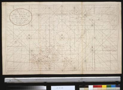
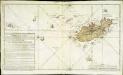
Nieuwe afteekening van een gedeelte van het Kanaal van Caep La Hague tot het eijland Guernsey naer de laetste Engelse afteekening
Guernsey Johannes van Keulen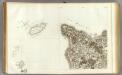
125 Cherbourg.
1 : 86400 Cassini family; Cassini, Cesar-Francois, 1714-1784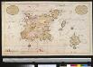
t Eijland Garnseij of Isle Grenezeij of Guerneze, behoort aen de Engelsche, is geleegen int Kanaal in de Kiskasse bij C. de La Hague, met alle desselfs geleegentheeden int groot
Guernsey Gerard van Keulen
Garnsey.[Karte], in: Novus atlas absolutissimus, Bd. 8, S. 115.
1 Karte aus Atlas Janssonius Offizin
Garnesay [Karte], in: Atlas, sive, Cosmographicae meditationes de fabrica mundi et fabricati figura, S. 125.
1 Karte aus Atlas Mercator, Gerhard
Garnesay [Karte], in: Gerardi Mercatoris Atlas, sive, Cosmographicae meditationes de fabrica mundi et fabricati figura, S. 130.
1 Karte aus Atlas Mercator, Gerhard Montanus, Petrus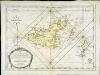
Carte de l'isle de Grenesey
1 Karte : Kupferdruck ; 38 x 53 cm Bellin s.n.
Carte topo-hidro-graphique des isles de Grenesey Cers et Erm.s
1 Karte : Kupferdruck ; 51 x 67 cm Beaurain chez le chévalier de Beaurain rue Git-le-Cœur la 1.ere porte à droite en entrant par le quay des Augustins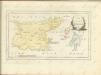
Carte topo-hidro-graphique des isles d'Aurigny, de Burhou et des Casquet
1 Karte : Kupferdruck ; 38 x 67 cm Beaurain chez le chevalier de Beaurain rue Git le Cœur la 1.ere porte à droite en entrant par le quay des Augustins
Ordnance survey map of Guernsey
1 : 21120 Guernsey (Normanské ostrovy : ostrov) Ordnance survey office
Carte reduite de l'isle d'Aurigni et des isles et roches voisines
1 Karte : Kupferdruck ; 39 x 53 cm Bellin s.n.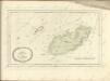
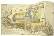
Guernsey Castle.
This is a plan of Guernsey Castle, drawn shortly after 1593. It is a pictorial fortification plan with proposals for improvements. It is possible that Paul Ivey, the leading fortification consultant of the second half of Elizabeth I’s reign, was the draughtsman of this plan as he was studying the defences of the Channel Islands in 1593. The plan is marked with alphabetical references indicating work done previously, the location of suggested earthworks and of a proposed bulwark. At some point the plan has been trimmed resulting in the partial loss of the compass rose. Ivey, Paul
Een gedeelte van het Kanaal van Cherborgh tot t eijland Jerseij
France Gerard van Keulen
Carte des isles Jersey Grenesey Aurigny et Cers
1 Karte auf 2 Blättern : Kupferdruck ; 67 x 89 cm Lattré chez Lattré graveur ordinaire du roi de M. le Duc d'Orléans et de la ville rue St. Jacques la porte cochere vis-à-vis celle de la parcheminerie à la ville de Bordeaux

Remote British Isles: Jersey and Guernsey, Scilly Isles, Shetland Isles.
1 : 196000 Pinkerton, John, 1758-1826
Diocese de Coutances, [feuille 1 et 3]
2 Blätter : Dezauche
[Cherbourg]
1 Blatt : 60 x 91 cm s.n.
Sarnia Insula, Vulgo Garnsey: et Insula Caesarea, Vernacule Garsey. [Karte], in: Theatrum orbis terrarum, sive, Atlas novus, Bd. 4, S. 538.
1 Karte aus Atlas Blaeu, Joan Blaeu, Willem Janszoon
Sarnia Insula, Vulgo Garnsey: et Insula Caesarea, Vernacule Garsey. [Karte], in: Theatrum orbis terrarum, sive, Atlas novus, Bd. 4, S. 533.
1 Karte aus Atlas Blaeu, Joan Blaeu, Willem Janszoon
Channel Islands. (with) inset map of the English Channel.
1 : 82368 Tallis, J. & F.
SARNIA INSVLA, | Vulgo | GARNSEY: | et | INSVLA CÆSAREA, | Vernacule | JARSEY.
[Amsterdam : Joan Blaeu]
Sarnia Insula, Vulgo Garnsey: et Insula Caesarea, Vernacule Jarsey. [Karte], in: Le théâtre du monde, ou, Nouvel atlas contenant les chartes et descriptions de tous les païs de la terre, Bd. 4, S. 449.
1 Karte aus Atlas Blaeu, Willem Janszoon und Blaeu, Joan Blaeu, Willem Janszoon
Sarnia insvla, vulgo Garnsey: et insvla Cæsarea, vernacule Iarsey
1 Karte : Kupferdruck ; 39 x 51 cm Blaeu Joan Blaeu
Channel Islands.
1 : 147840 Stanford, Edward
Jersey, Guernsey.
1 : 364000 Faden, William, 1750?-1836
Carte reduite des isles de Jersey, Grenesey et d'Aurigny
1 Karte : Kupferdruck ; 54 x 40 cm Bellin s.n.