Maps of Nannestad

Trigonometrisk grunnlag, vedlegg 58
1 : 50000
Trigonometrisk grunnlag, vedlegg 53: Kart over endeel Triangler
1 : 50000 N. S. Darre
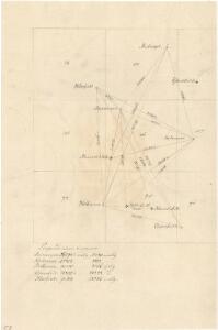
Trigonometrisk grunnlag, vedlegg 23: Fundament Kaart over Qvadrat Milene No 105 og 106
1 : 50000
20A Nannestad
1 : 100000 Johan Ferdinand Normann | Carl Christian Olberg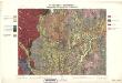
Geologiske kart 30: Den geologiske Undersøgelse, Nannestad
1 : 100000 T. Ch. Thomassen | Normann | Johan H. L. Vogt Norges geologiske undersøkelse
20A Nannestad
1 : 100000 Carl Christian Olberg | Johan Ferdinand Normann
1915-3 Nannestad
1 : 50000 Statens kartverk
1915-3 Nannestad
1 : 50000 Statens kartverk
1915-3 Nannestad
1 : 50000 Statens kartverk
20A Nannestad
1 : 100000 Johan Ferdinand Nordmann | Ole Engh
20A Nannestad
1 : 100000 Johan Ferdinand Normann | Carl Christian Olberg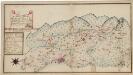
Kartblad 173: Situations Chart over det Nannestadske Captain Hans Abelsteds andfortroede Dragoner Compagni District
C. A. Hiorth
20A Nannestad
1 : 100000 Johan Ferdinand Normann | Carl Christian Olberg
Kartblad 65: Wey-Cart over det Eidswoldske lette Infanterie Compagnie District

1915-3 Nannestad
1 : 50000 Norges Geografiske Oppmåling
Trigonometrisk grunnlag, vedlegg 30: Fundament Tabel Quadrat-Miilen No 116 og 117
1 : 10000
1915-3 Nannestad
1 : 50000 Norges Geografiske Oppmåling
1915-3 Nannestad
1 : 50000 Norges Geografiske Oppmåling
Spesielle kart 153: Kartvedlegg til innstilling om skolekretsinndeling i Nannestad
1 : 50000 Norges Geografiske Oppmåling
Kartblad 4 Cituations-Cart over det Edsvoldske Compagnies Distrigt
Neumann
1915-4 Hurdal
1 : 50000 Norges Geografiske Oppmåling
Kartblad 24: Wei-Kaart over det Schijedsmoiske Compagnie District
Lihme senior
Ekserserplasskart; Gardermoen sydlig blad
1 : 50000
Kartblad II: Vei-kaart over den trondhjemske Kongevei fra Christiania til Røraas gjennom Eidsvold, Rommedal, Levthen og Østerdalen
1 : 20000 J. H. Reichborn
20A 1

1915-4 Hurdal
1 : 50000 Norges Geografiske Oppmåling
1915-4 Hurdal
1 : 50000 Statens kartverk
1915-4 Hurdal
1 : 50000 Statens kartverk
1915-4 Hurdal
1 : 50000 Statens kartverk