Maps of Nittedal

20A 5 sv
1 : 25000 Gustav Adolf Tajet
20A 5
1 : 20000 Jørgen Scielderup Grimseth
20A 1 nv
1 : 25000 Gustav Adolf Tajet
20A 1 nv
1 : 25000 Johannes Solem
20A 1 nø
1 : 25000 Johannes Solem
1915-3 Nannestad
1 : 50000 Norges Geografiske Oppmåling
1915-3 Nannestad
1 : 50000 Norges Geografiske Oppmåling
1915-3 Nannestad
1 : 50000 Norges Geografiske Oppmåling
20A 1

20A 1 sv
1 : 25000 Andreas Theodor Walle
19B 4 nø
1 : 25000 Thorolf Bjørnstad
19B 4 nø
1 : 25000 Thorolf Bjørnstad | Oscar Thue | Gunvald Hagene
20A 1
1 : 20000 Grimsæth
19B 4 nø
1 : 25000 Johannes Solem
1915-3 Nannestad
1 : 50000 Statens kartverk
1915-3 Nannestad
1 : 50000 Statens kartverk
1915-3 Nannestad
1 : 50000 Statens kartverk
19B 8; 19B 12
1 : 50000 Per Tang | Oscar Thue
Trigonometrisk grunnlag, vedlegg 58
1 : 50000
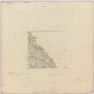
Kartblad 24: Wei-Kaart over det Schijedsmoiske Compagnie District
Lihme senior
Kristiania omegn / Heliogravure efter Tegning af Karttegner J. Natrud ; Fjeldtonen af O. Engh
1 : 25000 J. Natrud; O. Engh [S.l. : Norges geografiske Opmaaling]
20A Nannestad
1 : 100000 Johan Ferdinand Normann | Carl Christian Olberg
20A Nannestad
1 : 100000 Carl Christian Olberg | Johan Ferdinand Normann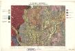
Geologiske kart 30: Den geologiske Undersøgelse, Nannestad
1 : 100000 T. Ch. Thomassen | Normann | Johan H. L. Vogt Norges geologiske undersøkelse
Finmarkens amt 54-2: HÃ¥ndtegnet kopi av kart over Ã...rdalstangen
1 : 200000 Fredrik Rode, Gerhard Munthe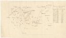
Trigonometrisk grunnlag, vedlegg 59
1 : 50000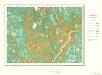
Geologisk kart 10 Nannestad
1 : 100000
Trigonometrisk grunnlag, vedlegg 53: Kart over endeel Triangler
1 : 50000 N. S. Darre
Spesielle kart 35: Oversigtskart over de mellem Christiania og Hadeland udstukne Linier
1 : 100000