Maps of Nittedal

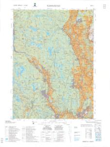
1915-3 Nannestad
1 : 50000 Statens kartverk
1915-3 Nannestad
1 : 50000 Statens kartverk
1915-3 Nannestad
1 : 50000 Statens kartverk
Kartblad 24: Wei-Kaart over det Schijedsmoiske Compagnie District
Lihme senior
1915-3 Nannestad
1 : 50000 Norges Geografiske Oppmåling
1915-3 Nannestad
1 : 50000 Norges Geografiske Oppmåling
1915-3 Nannestad
1 : 50000 Norges Geografiske Oppmåling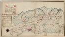
Kartblad 173: Situations Chart over det Nannestadske Captain Hans Abelsteds andfortroede Dragoner Compagni District
C. A. Hiorth
Spesielle kart 153: Kartvedlegg til innstilling om skolekretsinndeling i Nannestad
1 : 50000 Norges Geografiske Oppmåling
20A 1

20A 5 sv
1 : 25000 Gustav Adolf Tajet
20A 1 nv
1 : 25000 Gustav Adolf Tajet
20A 1 sv
1 : 25000 Andreas Theodor Walle
Jegerkorps nr 12A: Kart over Aker, Enebak, Nittedal, Skedsmo og Lørenskog, øst
1 : 13000 von Krebs | Ulven
20A 5
1 : 20000 Jørgen Scielderup Grimseth
20A 1
1 : 20000 Grimsæth
Jegerkorps nr 12A: Kart over Aker, Enebak, Nittedal, Skedsmo og Lørenskog, vest
1 : 13000 Ulven | von Krebs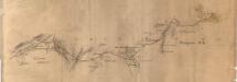
Fra Bånkallenga til Skedsmo kirke
1 : 20000 J. H. Reichborn
20A 2
1 : 20000
19B 4 nø
1 : 25000 Thorolf Bjørnstad
Ekserserplasskart; Kart over Gardermoen
1 : 12500 A. Thirud
19B 4 nø
1 : 25000 Thorolf Bjørnstad | Oscar Thue | Gunvald Hagene
20A 9
1 : 20000 O. Lund | Stockfleth
Fra Fløgstad til Smedstua
1 : 20000 J. H. Reichborn
19B 4 sø
1 : 25000 Niels Sire
Ekserserplasskart; Kart over Gardermoen
1 : 25000 A. Thirud
20A 10
1 : 20000 O. Lund | Stockfleth
Fra Oslo domkirke til Romsås
1 : 20000 J. H. Reichborn
Kartblad I: Vei-kaart over den trondhjemske Kongevei fra Christiania til Røraas gjennom Eidsvold, Rommedal, Levthen og Østerdalen
1 : 20000 J. H. Reichborn