Maps of Kongsvinger

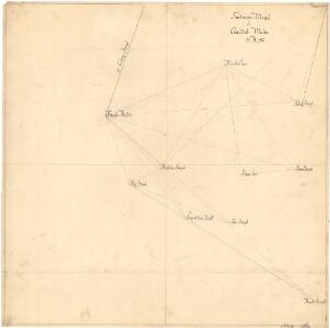
Trigonometrisk grunnlag, vedlegg 18: Fundament Mensul for Quadrat-Milen No 92
1 : 10000 Niels Andreas Wibe | Hans Nicolai Archtander
20B 6
1 : 50000 Johannes Solem
Mil nr 99
1 : 10000 Niels Stockfleth Darre
20B-6-vest
1 : 10000 Hans Frederich Tambs | Hans Nicolai Archtander
20B-6-øst
1 : 10000 Hans Nicolai Archtander | Hans Frederich Tambs
Mil nr 99
1 : 10000 Niels Stockfleth Darre
20B-6-sv
1 : 10000 Hans Nicolai Archtander | Hans Frederich Tambs
Nr. 8; felt 2 og 6 (en del)
1 : 25000 I. Smith-Kielland
20B-6-nv
1 : 10000 Hans Nicolai Archtander | Hans Frederich Tambs
20B-6-sø
1 : 10000 Hans Frederich Tambs | Hans Nicolai Archtander
20B-6-nø
1 : 10000 Hans Nicolai Archtander | Hans Frederich Tambs
Nr. 8; felt 3 halve sør og 7
1 : 25000 J. Natrud
Nr. 8; felt 5; 6; 9 og 10
1 : 25000 O. J. Broch | H. Broch
Nr. 8; dele av felt 5 og 9
1 : 25000 R. Roscher Nielsen
Fra Fulu til Tarven
1 : 20000 J. H. Reichborn
Nr. 8; felt 7
1 : 25000 Stugstad
Kartblad III: Kart over Postveien fra Gaarden Kløften i Ullensager Sogn om Magnor til Rigsgrændsen
1 : 20000 J. H. Reichborn
Nr. 8; felt 4 og søndre del av 8
1 : 25000 Hans Løken | J. Natrud
Nr. 8; felt 10 halve nord
1 : 25000 J. Nielsen
20B 10
1 : 50000 Gunnar Anfin Lange
20B 5 øst
1 : 10000 Niels Stockfleth Darre
Kongsvinger
1 : 50000 Gerhard Munthe | Niels Arentz Ramm
2015-2 Kongsvinger
1 : 50000 Norges Geografiske Oppmåling
2015-2 Kongsvinger
1 : 50000 Statens kartverk
20B Kongsvinger
1 : 100000
20B Kongsvinger
1 : 100000
20B Kongsvinger
1 : 100000
Trigonometrisk grunnlag, vedlegg 15: Fundament Mensul for Sammenbindelsen af de gamle Operationer
1 : 50000 Hans Lemich Juell | Johan Henrik Ramm
2015-2 Kongsvinger
1 : 50000 Statens kartverk