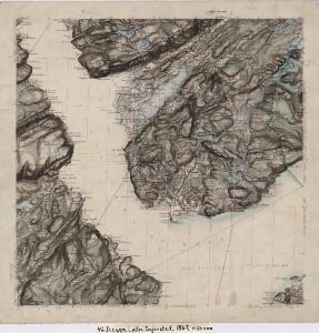
Maps of Agdenes

46D 5; 46D 6; 46D 9; 46D 10
1 : 50000 Johannes Sejersted
1522-2 Rissa
1 : 50000 Statens kartverk
1522-2 Stjörna
1 : 50000 Norges Geografiske Oppmåling
1522-2 Rissa
1 : 50000 Statens kartverk
1522-2 Rissa
1 : 50000 Statens kartverk
1522-2 Rissa
1 : 50000 Norges Geografiske Oppmåling
46D Trondhjem
1 : 100000 Torgrim Lundtvedt | Ole Engh
Museumskart 115: Specialkart over Trondhjemsfjorden - Sydlige del
1 : 100000 Solem
46D Trondhjem
1 : 100000 Torgrim Lundtvedt | Ole Engh
46D Trondhjem
1 : 100000 Torgrim Lundtvedt | Ole Engh
46D Trondhjem
1 : 100000
46D Trondhjem
1 : 100000
46D Trondhjem
1 : 100000 Torgrim Lundtvedt | Ole Engh
46D Trondhjem
1 : 100000 Torgrim Lundtvedt | Ole Engh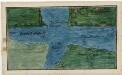
Kartblad 95: Det Stadsbøidiske Compagnie District

Ekserserplasskart; Kart over traktene omkring Agdenes
1 : 100000
1521-1 Orkanger
1 : 50000 Statens kartverk
1521-1 Orkanger
1 : 50000 Statens kartverk
1521-1 Orkanger
1 : 50000 Statens kartverk
1521-1 Orkanger
1 : 50000 Norges Geografiske Oppmåling
1521-1 Byneset
1 : 50000 Norges Geografiske Oppmåling
1521-1 Orkanger
1 : 50000 Statens kartverk
F24-6-nø/6
1 : 25000 Gustav Adolf Tajet | Berthold Dahl
Geologiske kart 14: Den geologiske Undersøgelse, Trondhjem
1 : 100000 H. T. Bjørnstad | M. Bugge Norges geologiske undersøkelse
Kartblad 96: Situations-Cart over det Redsenske Compagnie
Johan Christian Throne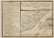
Kartblad 77- Situations Chart over det Frostensche Compagnie; versjon 1
Ebbe Carsten Hendrich Coldevin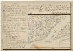
Kartblad 77-2: Situations Chart over det Frostensche Compagnie; versjon 2
Ebbe Carsten Hendrich Coldevin
Kartblad 97: Cart over det Ridtzenske Compagnies District

Kartblad 10 Situations Cart over det Børsensche Compagnies Destrichte
Casper Fridrich von Brodtkorb