Maps of Indre Fosen

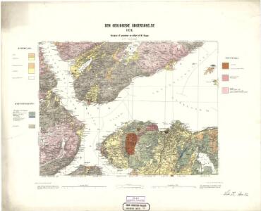
Geologiske kart 14: Den geologiske Undersøgelse, Trondhjem
1 : 100000 H. T. Bjørnstad | M. Bugge Norges geologiske undersøkelse
46D Trondhjem
1 : 100000 Torgrim Lundtvedt | Ole Engh
Museumskart 115: Specialkart over Trondhjemsfjorden - Sydlige del
1 : 100000 Solem
46D Trondhjem
1 : 100000 Torgrim Lundtvedt | Ole Engh
Kartblad 95: Det Stadsbøidiske Compagnie District

46D Trondhjem
1 : 100000 Torgrim Lundtvedt | Ole Engh
46D Trondhjem
1 : 100000
46D Trondhjem
1 : 100000
46D Trondhjem
1 : 100000 Torgrim Lundtvedt | Ole Engh
46D Trondhjem
1 : 100000 Torgrim Lundtvedt | Ole Engh
Museumskart 116: Deler av Trondhimsfjorden
1 : 75000 Solem
Kartblad 92: Wey-Carte over det Strindenske Compagnie District
Jørgen Nicolaus Winther Bay
1622-3 Leksvik
1 : 50000 Statens kartverk
1622-3 Leksvik
1 : 50000 Norges Geografiske Oppmåling
1522-2 Rissa
1 : 50000 Statens kartverk
1521-1 Orkanger
1 : 50000 Statens kartverk
1621-4 Trondheim
1 : 50000 Norges Geografiske Oppmåling
1521-1 Byneset
1 : 50000 Norges Geografiske Oppmåling
46D 5; 46D 6; 46D 9; 46D 10
1 : 50000 Johannes Sejersted
1521-1 Orkanger
1 : 50000 Statens kartverk
1621-4 Trondheim
1 : 50000 Statens kartverk
1621-4 Trondheim
1 : 50000 Statens kartverk
46D 7; 46D 8; 46D 11; 46D 12
1 : 50000 Reinhold Ziegler
1521-1 Orkanger
1 : 50000 Statens kartverk
1621-4 Trondheim
1 : 50000 Norges Geografiske Oppmåling
1621-4 Trondheim
1 : 50000 Statens kartverk
1521-1 Orkanger
1 : 50000 Statens kartverk
1521-1 Orkanger
1 : 50000 Norges Geografiske Oppmåling
1621-4 Trondheim
1 : 50000 Statens kartverk