Maps of Skaun

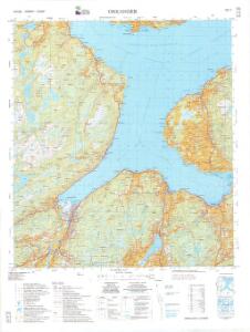
1521-1 Orkanger
1 : 50000 Statens kartverk
1521-1 Byneset
1 : 50000 Norges Geografiske Oppmåling
1521-1 Orkanger
1 : 50000 Norges Geografiske Oppmåling
1521-1 Orkanger
1 : 50000 Statens kartverk
1521-1 Orkanger
1 : 50000 Statens kartverk
1521-1 Orkanger
1 : 50000 Statens kartverk
46B 9; 46B 10; 46D 1; 46D 2
1 : 50000 Fredrik Christian Sejersted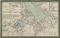
Kartblad 178: Kart over Konge- Post- og Alfar-Weiene igiennom det Byenæsiske Compagnie under det Trondhiemske Dragonregiment
1 : 60000
F25-12-nø/6
1 : 25000 Gustav Adolf Tajet
Kartblad 95: Det Stadsbøidiske Compagnie District

Kartblad 102: Kart over det Børsenske Compagnie District
A. Bull
Museumskart 115: Specialkart over Trondhjemsfjorden - Sydlige del
1 : 100000 Solem
Kartblad 103: Carte over det Budwigske Compagnie District
Ræder
46D Trondhjem
1 : 100000 Torgrim Lundtvedt | Ole Engh
46D Trondhjem
1 : 100000
46D Trondhjem
1 : 100000 Torgrim Lundtvedt | Ole Engh
46D Trondhjem
1 : 100000
46D Trondhjem
1 : 100000 Torgrim Lundtvedt | Ole Engh
46D Trondhjem
1 : 100000 Torgrim Lundtvedt | Ole Engh
46D 5; 46D 6; 46D 9; 46D 10
1 : 50000 Johannes Sejersted
F24-6-mø/6, G24-1-mv/6
1 : 25000 Niels Sire | Gustav Adolf Tajet
F24-6-sø/6, G24-1-sv/6
1 : 25000 Andreas Theodor Walle
G25-7-nv/6
1 : 25000 Thorleif Dagfinn Unneberg
F24-6-nø/6
1 : 25000 Gustav Adolf Tajet | Berthold Dahl
46D Trondhjem
1 : 100000 Torgrim Lundtvedt | Ole Engh
Geologiske kart 14: Den geologiske Undersøgelse, Trondhjem
1 : 100000 H. T. Bjørnstad | M. Bugge Norges geologiske undersøkelse
Spesielle kart 22-1: Rognæs - Trondheim
1 : 400000 Albert Cammermeyer Forlag
Kartblad 10 Situations Cart over det Børsensche Compagnies Destrichte
Casper Fridrich von Brodtkorb
Geologiske kart 15: Den geologiske Undersøgelse, Melhus
1 : 100000 Theodor Kjerulf | J. Vogt | H. T. Bjørnstad | M. Bugge | C. Schultz Norges geologiske undersøkelse