Maps of Hamar

26A 6
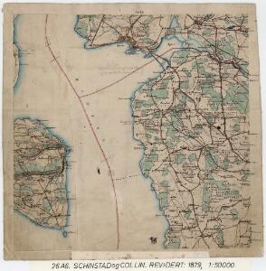
1 : 50000 Schinstad | Collin
26A 6
1 : 50000 Hans Knagenhjelm Hertzberg | Jacob Ager Laurantzon
26A 6 øst
1 : 20000 Svend Stenersen Collin
26A 6 vest
1 : 10000 Christian Schinstad
Fra Harstad til Frogner
1 : 20000 J. H. Reichborn
26A 6 sv
1 : 10000 Christian Schinstad
26A 6 sv
1 : 10000
26A 6 nv
1 : 10000 Christian Schinstad
26A 6 nv
1 : 10000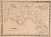
Hamar
1 : 50000 Gerhard Munthe | Niels Arentz Ramm
Hedemarkens amt nr 59b: Kart over Stange St. med omgivelser
1 : 2000 Nicolai Solner Krum
26A 1; 26A 2; 26A 5; 26A 6; 26A 9; 26A 10
1 : 50000 Frithjof Jacobsen
Trigonometrisk grunnlag, vedlegg 46
1 : 100000
Furnes kirke til Vang kirke
1 : 20000 J. H. Reichborn
Geologiske kart 26: Den geologiske Undersøgelse, Hamar
1 : 100000 M. Irgens | P. Krohn | Alfred Getz | F. Jacobsen | J. Vogt | Theodor Kjerulf Norges geologiske undersøkelse
26A Hamar
1 : 100000 F. Jacobsen | C. Pedersen
26A Hamar
1 : 100000
26A Hamar
1 : 100000 Ole Engh | F. Jacobsen
26A Hamar
1 : 100000 F. Jacobsen | Ole Engh
26A Hamar
1 : 100000 Ole Engh | F. Jacobsen
26A Hamar
1 : 100000 F. Jacobsen | Ole Engh
26A Hamar
1 : 100000
26A Hamar
1 : 100000 F. Jacobsen
Trigonometrisk grunnlag, vedlegg 51
1 : 50000
Geologisk kart 8b: Jordbundskart over en del af Mjøsens Omegn
1 : 100000 Theodor Kjerulf | Irgens
Kartblad 48: Militair Cart over det Stangeske Compagnie District
Falck
1916-4 Hamar
1 : 50000 Statens kartverk
Spesielle kart 33: Christiania - Gjøvik-Banen
1 : 100000
1916-1 Löten
1 : 50000 Norges Geografiske Oppmåling