Maps of Stange

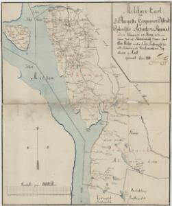
Kartblad 48: Militair Cart over det Stangeske Compagnie District
Falck
1916-2 Tangen
1 : 50000 Norges Geografiske Oppmåling
1916-2 Tangen
1 : 50000 Norges Geografiske Oppmåling
1916-2 Tangen
1 : 50000 Statens kartverk
1916-2 Tangen
1 : 50000 Statens kartverk
1916-2 Tangen
1 : 50000 Norges Geografiske Oppmåling
1916-2 Tangen
1 : 50000 Statens kartverk
26A 1; 26A 2
1 : 50000
26A 2
1 : 20000 Trygve Frivold Graff-Wang | Jacob Hvinden Haug
20C 10 a
1 : 50000 Frithjof Jacobsen
20C 10 b
1 : 50000 Finckenhagen
26A 3
1 : 50000 Frithjof Jacobsen
26A 2
1 : 50000 Frithjof Jacobsen
Fra Skrepperud til Håkårud
1 : 20000 J. H. Reichborn
26A 2
1 : 20000 Jørgen Scielderup Grimseth
Fra Korsøgarden til Nøkleby
1 : 20000 J. H. Reichborn
20C 11
1 : 20000
26A 3
1 : 20000 Jørgen Scielderup Grimseth
20C 10
1 : 20000 Niels Finckenhagen
H32-1; H32-2
1 : 50000 Andreas Theodor Walle
20C 11 b
1 : 50000 Frithjof Jacobsen
Kartblad IV: Vei-kaart over den trondhjemske Kongevei fra Christiania til Røraas gjennom Eidsvold, Rommedal, Levthen og Østerdalen
1 : 20000 J. H. Reichborn
20C 11 a
1 : 50000 Frithjof Jacobsen
H32-1; H32-2
1 : 50000 Andreas Theodor Walle
Fra Kollovangen til Løken
1 : 20000 J. H. Reichborn
Kartblad nr 1: Kaart over Postveien fra Korsødegaarden til Trondhjem igjennom Gulbrandsdalen over Dovrefjeld
1 : 20000 J. H. Reichborn
26A 6
1 : 50000 Hans Knagenhjelm Hertzberg | Jacob Ager Laurantzon
26A 6
1 : 50000 Schinstad | Collin
26A 7
1 : 50000 Grimsoth