Maps of Oslo

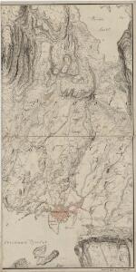
Mil nr 72 (Christiania)
1 : 10000 Niels Stockfleth Darre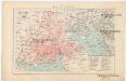
Kristiania
1 : 43000 Oslo (Norsko) F.A. Brockhaus' geogr.-artist. Anstalt
Oversiktskart over Kristiania amt nr 58
1 : 50000 J. W. G. Næser
Kristiania amt nr 63: Kart over Kristiania
1 : 5000 H. N. Bergh | J. W. G. Næser
14D-12
1 : 10000 Niels Stockfleth Darre
14D 12 nø
1 : 25000 Johannes Solem
Trigonometrisk grunnlag, Squelet-Cart 52: Trigonometrisk kart over Christiania og omegn
F. Næser
14D 12 sø
1 : 25000 Johannes Solem
Kristiania nr 82-1: Karta à ̧fver Staden Christiania i Norrige och Trakten der omkring
1 : 100000 O. J. Hagelstam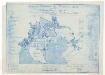
Kristiania amt nr 97
1 : 10000
14D 12 nø
1 : 10000 Ditlev Vibe
14D 12 nø
1 : 10000 W. Næser
Christiania
1 : 50000 Gerhard Munthe | Niels Arentz Ramm
Kristiania nr 82b: Karta à ̧fver Staden Christiania i Norrige och Trakten der omkring
1 : 10000 O. J. Hagelstam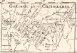
Gatorne i Christiania
1 : 50000 O. J. Hagelstam
Kristiania amt nr 60: Kart over Agershus Fæstning med Plan til dens fremtidige Bebyggelse
1 : 2000 C. Schwenzens Lit. Officin
Kristiania amt nr 60: Kart over Agershus Fæstning med Plan til dens fremtidige Bebyggelse
1 : 2000 C. Schwenzens Lit. Officin
Kristiania amt nr 58: Detailkart over Christiania efter Kommunebestyrelsens Foranstaltning trigonometrisk og geometrisk opmaalt
1 : 1000 J. W. G. Næser
Grønlibryggen
1 : 1000 J. W. G. Næser
Kristiania amt nr 58: Detailkart over Christiania efter Kommunebestyrelsens Foranstaltning trigonometrisk og geometrisk opmaalt
1 : 1000 J. W. G. Næser
Kristiania amt nr 58: Detailkart over Christiania efter Kommunebestyrelsens Foranstaltning trigonometrisk og geometrisk opmaalt
1 : 1000 J. W. G. Næser
Kristiania amt nr 58: Detailkart over Christiania efter Kommunebestyrelsens Foranstaltning trigonometrisk og geometrisk opmaalt
1 : 1000 J. W. G. Næser
Kristiania amt nr 58: Detailkart over Christiania efter Kommunebestyrelsens Foranstaltning trigonometrisk og geometrisk opmaalt
1 : 1000 J. W. G. Næser
Kristiania amt nr 58: Detailkart over Christiania efter Kommunebestyrelsens Foranstaltning trigonometrisk og geometrisk opmaalt
1 : 1000 J. W. G. Næser
Kristiania amt nr 58: Detailkart over Christiania efter Kommunebestyrelsens Foranstaltning trigonometrisk og geometrisk opmaalt
1 : 1000 J. W. G. Næser
Kristiania amt nr 58: Detailkart over Christiania efter Kommunebestyrelsens Foranstaltning trigonometrisk og geometrisk opmaalt
1 : 1000 J. W. G. Næser
Kristiania amt nr 58: Detailkart over Christiania efter Kommunebestyrelsens Foranstaltning trigonometrisk og geometrisk opmaalt
1 : 1000 J. W. G. Næser
Kristiania amt nr 58: Detailkart over Christiania efter Kommunebestyrelsens Foranstaltning trigonometrisk og geometrisk opmaalt
1 : 1000 J. W. G. Næser
Kristiania amt nr 58: Detailkart over Christiania efter Kommunebestyrelsens Foranstaltning trigonometrisk og geometrisk opmaalt
1 : 1000 J. W. G. Næser