Maps of Ullensaker

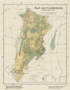
Ekserserplasskart; Kart over Gardermoen
1 : 12500 A. Thirud
Ekserserplasskart; Gardermomaalingen
1 : 12500 Helset | Hatledal
Fra Smedstua til Fjellberg
1 : 20000 J. H. Reichborn
Ekserserplasskart; Gardermomaalingen; nordre blad
1 : 12500 R. B. Møller
Spesielle kart 145: Gardermoen
1 : 50000
Ekserserplasskart; Kart over Gardermoen
1 : 25000 A. Thirud
20A 10
1 : 20000 O. Lund | Stockfleth
20A 6 nø
1 : 10000 Andreas Samuel Krebs
Akershus amt nr 116-5a: Terrenget nord for Kløfta
1 : 20000 Christophersen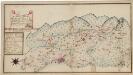
Kartblad 173: Situations Chart over det Nannestadske Captain Hans Abelsteds andfortroede Dragoner Compagni District
C. A. Hiorth
1915-2 Ullensaker
1 : 50000 Norges Geografiske Oppmåling
1915-2 Ullensaker
1 : 50000 Statens kartverk
Trigonometrisk grunnlag, vedlegg 23: Fundament Kaart over Qvadrat Milene No 105 og 106
1 : 50000
1915-2 Ullensaker
1 : 50000 Norges Geografiske Oppmåling
1915-1 Eidsvoll
1 : 50000 Norges Geografiske Oppmåling
1915-1 Eidsvoll
1 : 50000 Statens kartverk
1915-3 Nannestad
1 : 50000 Statens kartverk
1915-1 Eidsvoll
1 : 50000 Statens kartverk
1915-3 Nannestad
1 : 50000 Statens kartverk
1915-3 Nannestad
1 : 50000 Statens kartverk
Spesielle kart 153: Kartvedlegg til innstilling om skolekretsinndeling i Nannestad
1 : 50000 Norges Geografiske Oppmåling
1915-2 Jessheim
1 : 50000 Statens kartverk
1915-2 Ullensaker
1 : 50000 Statens kartverk
1915-2 Ullensaker
1 : 50000 Norges Geografiske Oppmåling
20A 6 nv uten grenser
1 : 10000 Andreas Samuel Krebs
20A 6 nv
1 : 10000 Andreas Samuel Krebs
Fra Ladderud til Karlstua
1 : 20000 J. H. Reichborn
Fra Fløgstad til Smedstua
1 : 20000 J. H. Reichborn
Kartblad 65: Wey-Cart over det Eidswoldske lette Infanterie Compagnie District