Maps of Wartburgkreis

Herzogtum Sachsen-Coburg und Gotha 1830 Verwaltungsstruktur
Sachsen-Coburg-Gotha Verwaltung Kunz, Andreas ; Moeschl, Joachim Robert
Herzogtum Sachsen-Coburg und Gotha 1826 Verwaltungsstruktur
Sachsen-Coburg-Gotha Verwaltung Kunz, Andreas ; Moeschl, Joachim Robert
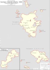
Herzogtum Sachsen-Coburg und Gotha 1834 Verwaltungsstruktur
Sachsen-Coburg-Gotha Verwaltung Kunz, Andreas ; Moeschl, Joachim Robert

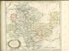
Hennebergensis Ditionis. vera delineatio [Karte], in: Theatrum orbis terrarum, S. 225.
1 Karte aus Atlas Ortelius, Abraham Vrients, Jan Baptista
Principatus Isenacensis cum adjacentibus vicinorum statuum ditionibus exhibitus
1 : 190000 Durynsko (Německo) Homann, Johann Baptist J. B. Homann
Principatus Hennenbergensis. [Karte], in: Novus atlas absolutissimus, Bd. 2, S. 177.
1 Karte aus Atlas Janssonius Offizin
Hennebergensis Ditionis. vera delineatio [Karte], in: Theatrum orbis terrarum, S. 133.
1 Karte aus Atlas Ortelius, Abraham
COMITATVS | HENNEBER- | GENSIS.
[Amsterdam : Joan Blaeu]
Principatus Isenacensis
1 : 210000 Mollova mapová sbírka Homann, Johann Baptist Homann, Johann Baptista
Inter Mayerianvm ad Mvsas Goettingenses
1 : 390000 Mollova mapová sbírka Mayer, Tobias Homann, Johann Baptista - dědici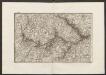
Militair Karte von Süd-Deutschland in 20 Sectionen
1 : 400000 2. Section Coulon, Alois von A. von Coulon
Thuringer-Wald-Gebirges.
1 : 380000 Grassl, J. (Joseph)
Geographische Charte
1 : 300000 Mollova mapová sbírka Zollmann, Friedrich
Karte des Thüringer-Wald-Gebirges zugleich special Karte des Herzogthums Sachs-Meiningen-Hildburghausen des Fürstenthums Coburg und der Schwarzburgischen Fürstenthümer Rudolstadt und Sondershausen
Grosser Hand-Atlas über alle Theile der Erde in 170 Karten Meyer, J. Verlag des Bibliographischen Instituts
Special Charte von dem Thüringer Walde
Durynský les (Německo) von dem Geographischen Institute
Tvringiae Noviss. descript.
1 : 520000 Mollova mapová sbírka Mellinger, Johann Plantin, Christoph (officina)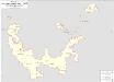
Herzogtum Sachsen-Meiningen 1826 Verwaltungsstruktur
Sachsen-Meiningen Verwaltung Kunz, Andreas ; Moeschl, Joachim Robert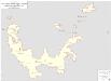
Herzogtum Sachsen-Meiningen 1829 Verwaltungsstruktur
Sachsen-Meiningen Verwaltung Kunz, Andreas ; Moeschl, Joachim Robert
Herzogtum Sachsen-Meiningen 1820 Verwaltungsstruktur
Sachsen-Meiningen Verwaltung Kunz, Andreas ; Moeschl, Joachim Robert
S. R. I. Comitatvs Henneberg
1 : 150000 Mollova mapová sbírka Zinck, Johann Jacob Homann, Johann Baptista - dědici
S. R. I. Comitatvs Henneberg
1 : 150000 Mollova mapová sbírka Zinck, Johann Jacob Homann, Johann Baptista - dědici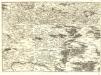
S.R.Imp. Circuli Franconici Geographica Delineatio Francken-Land mit Seinen Gräntzen
Mollova mapová sbírka Endter, Wolfgang Moritz Endter, Wolfgang Moritz
Principatus Hennenbergensis
1 : 300000 Mollova mapová sbírka Hondius, Henricus Schenk, Peter I
Principatus Hennenbergensis
1 : 300000 Mollova mapová sbírka Hondius, Henricus Janssonius, Johannes I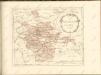

Carte pour Servir de Suite à la Partie Meridionale du Landgraviat de Hesse-Cassel avec les pays voisins de la Thüringe
1 : 200000 Mollova mapová sbírka Brönner, Heinrich Ludwig Broenner, Heinrich Ludwig
[Neueste Karte vom Herzogth: Gotha und angränzend: Ländern]
Grosser Hand-Atlas über alle Theile der Erde in 170 Karten Meyer, J. Verlag des Bibliographischen Instituts
Geognostische Uebersichtskarte des Thüringer Waldes
1 : 100000 Beyschlag, Franz ; Pütz, M. Simon Schropp