Maps of Landkreis Gotha

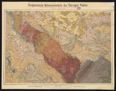
Geognostische Uebersichtskarte des Thüringer Waldes
1 : 100000 Beyschlag, Franz ; Pütz, M. Simon Schropp
Der Thüringerwald

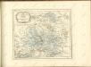
[Neueste Karte vom Herzogth: Gotha und angränzend: Ländern]
Grosser Hand-Atlas über alle Theile der Erde in 170 Karten Meyer, J. Verlag des Bibliographischen Instituts
127. Gotha, uit: Topographische Uebersichtskarte des Deutschen Reiches / herausgegeben v. d. Kartogr. Abt. d. Königl. Preuß. Landesaufnahme
1 : 200000 titelvariant: Topogr. Übersichtskarte des Deutschen Reiches; Annotatie: Titel boven bladen ook: Topogr. Übersichtskarte des Deutschen Reiches; Annotatie geografische gegevens: Op elk blad twee maatstokken: 10 Kilometer = 5,5 cm; 1 geogr. Meile = 3,6 cm; Legenda onder op elk blad Königlich Preußische Landesaufnahme. Kartographische Abtheilung [S.l : Königlich Preußische Landesaufnahme, Kartographische Abtheilung]
Herzogtum Sachsen-Meiningen 1820 Verwaltungsstruktur
Sachsen-Meiningen Verwaltung Kunz, Andreas ; Moeschl, Joachim Robert

Geognostische Karte des Thüringer Waldes. Nordwestliche Hälfte
1 : 200000 Geognostische Karte des Thüringer Waldes Credner, Heinrich Justus Perthes
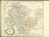
Gotha Herzogthum.
1 : 200000 Meyer, Joseph, 1796-1856
[Recto], uit: Geognostische Übersichtskarte des Thüringer Waldes / F. Beyschlag
1 : 100000 Annotatie: Omslagtitel Franz Heinrich August Beyschlag 1856-1915 [S.l. : s.n.]
164 Schleusingen, uit: Topographische Special-Karte von Deutschland (von Central-Europa) / begründet von D.G. Reymann ; [entworfen und gezeichn. von Heinrich Berghaus... [et al.]]
1 : 200000 Annotatie: Lit.: Daniel Gottlob Reymann und die "Topographische Special-Karte von Deutschland" / von Wolfgang Scharfe, in: Kartographische Nachrichten, 39 (1989), Heft I, p. 1-10; Handgeschreven titel: Reymann's Deutschland : 24 Sectionen: Jena, Penig, Dresden, Zittau, Hirschberg, Breslau, Brieg, Andernach, Coblenz, Giessen, Fulda, Schleusingen, Plauen, Zwickau, Teplitz, Jung Bunzlau, Hohenelbe, Glatz, Neisse, Simmern, Prag, Luxemburg, Birkenfeld; Aanwezig: 23 bladen Reymann, Daniel Gottlob; Berghaus, Heinrich [Berlin : 2. Departement des Kriegsministeriums, Bureau für Plan- und Kartenzeichnung]

Nova Territori[i] Erfordien[sis] in Suas Praefecturas accurate divisi descriptio cui accedit Erfordiae Urbis exterior Facies et Prospectus
1 : 90000 Mollova mapová sbírka Homann, Johann Baptist Homann, Johann Baptista
Nova teritorii Erfordien in suas praefecturas accurate divisi descriptio
1 : 90000 Durynsko (Německo) Homann, Johann Baptist Zollmann, Friedrich J.B. Homann
Nova teritorii Erfordien in suas praefecturas
1 : 90000 Durynsko (Německo) Homann, Johann Baptist J. B. Homann

Carte von Eisenach und umliegenden Gegend
Sartorius, Georg Christian
Meßtischblatt 5433 : Gräfenthal, [nach 1945]
1 : 250000 Gräfenthal. - Aufn. 1903, bericht. 1935, letzte Nachtr. 1936, redakt. Änd. 1938. - 1:25000. - [Berlin]: Reichsamt für Landesaufnahme, [nach 1945]. - 1 Kt.
Meßtischblatt 3181 : Gräfenthal, 1929
1 : 250000 Gräfenthal. - Hrsg. 1905, einz. Nachtr. 1919, gedr. [19]29. - 1:25000. - [Berlin]: Reichsamt für Landesaufnahme, 1929. - 1 Kt.
Meßtischblatt 3181 : Gräfenthal, 1905
1 : 250000 Gräfenthal. - Aufn. 1903. - 1:25000. - [Berlin]: Kgl. Preuss. Landesaufnahme, 1905. - 1 Kt.
Meßtischblatt 3181 : Gräfenthal, 1873
1 : 250000 Gräfenthal. - Aufn. 1856. - 1:25000. - [Berlin]: Kgl. Min. f. Handel, 1873. - 1 Kt.
Meßtischblatt 5432 : Großbreitenbach, 1939
1 : 250000 Großbreitenbach. - Hrsg. 1905, bericht. 1934, letzte Nachtr. 1936. - 1:25000. - [Berlin]: Reichsamt für Landesaufnahme, 1939. - 1 Kt.
Meßtischblatt 3180 : Großbreitenbach, 1930
1 : 250000 Großbreitenbach. - Hrsg. 1900, einz. Nachtr. 1919, gedr. [19]30. - 1:25000. - [Berlin]: Reichsamt für Landesaufnahme, 1930. - 1 Kt.
Meßtischblatt 5431 : Unterneubrunn, 19039
1 : 250000 Unterneubrunn. - Hrsg. 1905, bericht. 1934, letzte Nachtr. 1936. - 1:25000. - [Berlin] : Reichsamt für Landesaufnahme, 1939. - 1 Kt.
Meßtischblatt 3179 : Unterneubrunn, 1905
1 : 250000 Unterneubrunn. - Aufn. 1903. - 1:25000. - [Berlin]: Kgl. Preuss. Landesaufnahme, 1905. - 1 Kt.
Meßtischblatt 5430 : Schleusingen, 1940
1 : 250000 Schleusingen. - Hrsg. 1905. - 1:25000. - [Berlin]: Reichsamt für Landesaufnahme, 1940. - 1 Kt.
Meßtischblatt 3178 : Schleusingen, 1919
1 : 250000 Schleusingen. - Aufn. 1903, kl. Nachtr. 1919. - 1:25000. - [Berlin]: Reichsamt für Landesaufnahme, 1919. - 1 Kt.