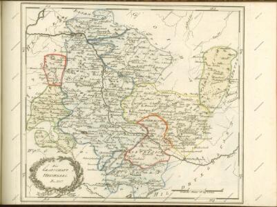
Maps of Landkreis Schmalkalden-Meiningen

164 Schleusingen, uit: Topographische Special-Karte von Deutschland (von Central-Europa) / begründet von D.G. Reymann ; [entworfen und gezeichn. von Heinrich Berghaus... [et al.]]
1 : 200000 Annotatie: Lit.: Daniel Gottlob Reymann und die "Topographische Special-Karte von Deutschland" / von Wolfgang Scharfe, in: Kartographische Nachrichten, 39 (1989), Heft I, p. 1-10; Handgeschreven titel: Reymann's Deutschland : 24 Sectionen: Jena, Penig, Dresden, Zittau, Hirschberg, Breslau, Brieg, Andernach, Coblenz, Giessen, Fulda, Schleusingen, Plauen, Zwickau, Teplitz, Jung Bunzlau, Hohenelbe, Glatz, Neisse, Simmern, Prag, Luxemburg, Birkenfeld; Aanwezig: 23 bladen Reymann, Daniel Gottlob; Berghaus, Heinrich [Berlin : 2. Departement des Kriegsministeriums, Bureau für Plan- und Kartenzeichnung]
Gefechte bei Zella und Rossdorf, 4.Juli 1866
1 : 25000 Topograph. Bureau des k.b. Generalquartiermeister-Stabes
Meßtischblatt 3235 : Eisfeld, 1929
1 : 250000 Eisfeld. - Hrsg. 1906, bericht. 1929. - 1:25000. - [Berlin]: Reichsamt für Landesaufnahme, 1929. - 1 Kt.
Meßtischblatt 5531 : Eisfeld, nach 1929
1 : 250000 Eisfeld. - Hrsg. 1906, bericht. 1929. - 1:25000. - [Berlin]: Reichsamt für Landesaufnahme, nach 1929. - 1 Kt.
Meßtischblatt 5530 : Hildburghausen, 1936
1 : 250000 Hildburghausen. - Hrsg. 1906, bericht. 1929, letzte Nachtr. 1936. - 1:25000. - [Berlin]: Reichsamt für Landesaufnahme, 1936. - 1 Kt.
Meßtischblatt 3234 : Hildburghausen, 1919
1 : 250000 Hildburghausen. - Aufn. 1904, hrsg. 1906, Aufl.-dr. 1919. - 1:25000. - [Berlin]: Reichsamt für Landesaufnahme, 1919. - 1 Kt.
Meßtischblatt 5529 : Haina, 1936
1 : 250000 Haina. - Hrsg. 1906, bericht. 1929, letzte Nachtr. 1936. - 1:25000. - [Berlin]: Reichsamt für Landesaufnahme, 1936. - 1 Kt.
Meßtischblatt 3233 : Dingsleben, 1873
1 : 250000 Dingsleben. - Aufn. 1856. - 1:25000. - [Berlin]: Kgl. Preuss. Min. f. Handel, 1873. - 1 Kt.
Meßtischblatt 5528 : Rentwertshausen (Mühlfeld), 1953
1 : 250000 Rentwertshausen (Mühlfeld). - Hrsg. 1906, bericht. 1927/29, letzte Nachtr. 1936. - 1:25000. - [Berlin]: MdI, 1953. - 1 Kt.
Meßtischblatt 5527 : Ostheim v. d. Rhön, 1952
1 : 250000 Ostheim v. d. Rhön. - Hrsg. 1906. - 1:25000. - [Berlin]: Vermessungsdienst des Landes Sachsen-Anhalt, 1952. - 1 Kt.
Meßtischblatt 428 : Ostheim, 1874
1 : 250000 Ostheim. - Aufn. 1857. - 1:25000. - [Berlin]: Kgl. Preuss. Min. f. Handel, 1874. - 1 Kt.
Meßtischblatt 5431 : Unterneubrunn, 19039
1 : 250000 Unterneubrunn. - Hrsg. 1905, bericht. 1934, letzte Nachtr. 1936. - 1:25000. - [Berlin] : Reichsamt für Landesaufnahme, 1939. - 1 Kt.
Meßtischblatt 3179 : Unterneubrunn, 1905
1 : 250000 Unterneubrunn. - Aufn. 1903. - 1:25000. - [Berlin]: Kgl. Preuss. Landesaufnahme, 1905. - 1 Kt.
Meßtischblatt 5430 : Schleusingen, 1940
1 : 250000 Schleusingen. - Hrsg. 1905. - 1:25000. - [Berlin]: Reichsamt für Landesaufnahme, 1940. - 1 Kt.
Meßtischblatt 3178 : Schleusingen, 1919
1 : 250000 Schleusingen. - Aufn. 1903, kl. Nachtr. 1919. - 1:25000. - [Berlin]: Reichsamt für Landesaufnahme, 1919. - 1 Kt.
Meßtischblatt 3178 : Schleusingen, 1905
1 : 250000 Schleusingen. - Aufn. 1903. - 1:25000. - [Berlin]: Kgl. Preuss. Landesaufnahme, 1905. - 1 Kt.
Meßtischblatt 5429 : Themar, 1940
1 : 250000 Themar. - 1:25000. - [Berlin]: Reichsamt für Landesaufnahme, 1940. - 1 Kt.
Meßtischblatt 3177 : Themar, 1905
1 : 250000 Themar. - Aufn. 1903. - 1:25000. - [Berlin]: Reichsamt für Landesaufnahme, 1905. - 1 Kt.
Meßtischblatt 5428 : Meiningen, 1936
1 : 250000 Meiningen. - Hrsg. 1905, einz. Nachtr. 1936. - 1:25000. - [Berlin]: Reichsamt für Landesaufnahme, 1936. - 1 Kt.
Meßtischblatt 5427 : Helmershausen, 1940
1 : 250000 Helmershausen. - Aufn. 1904, hrsg. 1906. - 1:25000. - [Berlin]: Reichsamt für Landesaufnahme, 1940. - 1 Kt.
Meßtischblatt 3175 . Helmershausen, 1906
1 : 250000 Helmershausen. - Aufn. 1904. - 1:25000. - [Berlin]: Kgl. Preuss. Landesaufnahme, 1906. - 1 Kt.
Meßtischblatt 3175 : Helmershausen, 1878
1 : 250000 Helmershausen. - Aufn. 1857, hrsg. 1874, bericht. 1878. - 1:25000. - [Berlin]: Kgl. Preuss. Min. f. Handel, 1878. - 1 Kt.
Meßtischblatt 5426 : Hilders, 1953
1 : 250000 Hilders. - Hrsg. 1906, letzte Nachtr. 1936, redakt. Änd. 1953 . - 1:25000. - [Berlin]: MdI, 1953. - 1 Kt.
Meßtischblatt 3174 : Hilders, 1906
1 : 250000 Hilders. - Aufn. 1904. - 1:25000. - [Berlin]: Reichsamt für Landesaufnahme, 1906. - 1 Kt.
Meßtischblatt 3120, neue Nr. 5331 : Ilmenau, 1938
1 : 250000 Ilmenau. - Aufn. 1903, hrsg. 1905, bericht. 1934, letzte Nachtr. 1936, redakt. Änd. [19]38. - 1:25000. - [Berlin]: Reichsamt für Landesaufnahme, 1938. - 1 Kt.
Meßtischblatt 3120 : Ilmenau, 1919
1 : 250000 Ilmenau. - Aufn. 1903, Nachtr. 1919. - 1:25000. - [Berlin]: Reichsamt für Landesaufnahme, 1919. - 1 Kt.
Meßtischblatt 3120 : Ilmenau, 1905
1 : 250000 Ilmenau. - Aufn. 1903. - 1:25000. - [Berlin]: Kgl. Preuss. Landesaufnahme, 1905. - 1 Kt.
Meßtischblatt 5330 : Suhl, 1938
1 : 250000 Suhl. - Hrsg. 1905, einz. Nachtr. 1936, gedr. [19]38. - 1:25000. - [Berlin]: Reichsamt für Landesaufnahme, 1938. - 1 Kt.
Meßtischblatt 3119 : Suhl, 1916
1 : 250000 Suhl. - Aufn. 1903, hrsg. 1905, Aufl.-dr. 1916. - 1:25000. - [Berlin]: Kgl. Preuss. Landesaufnahme, 1916. - 1 Kt.
Meßtischblatt 3119 : Suhl, 1912
1 : 250000 Suhl. - Aufn. 1903, hrsg. 1905. - 1:25000. - [Berlin]: Reichsamt für Landesaufnahme, 1912. - 1 Kt.