Maps of Germany

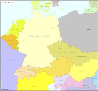
Mitteleuropa 1991
Mitteleuropa Kunz, Andreas ; Treiling, Thomas
Mitteleuropa 1848
Mitteleuropa Kunz, Andreas ; Moeschl, Joachim Robert
Mitteleuropa 1867
Mitteleuropa Kunz, Andreas ; Moeschl, Joachim Robert
Mitteleuropa 1871
Mitteleuropa Kunz, Andreas ; Moeschl, Joachim Robert
Mitteleuropa 1860
Mitteleuropa Kunz, Andreas ; Moeschl, Joachim Robert
Mitteleuropa 1957
Mitteleuropa Kunz, Andreas ; Treiling, Thomas
Mitteleuropa 1914
Mitteleuropa Kunz, Andreas ; Moeschl, Joachim Robert
Mitteleuropa 1820
Mitteleuropa Kunz, Andreas ; Moeschl, Joachim Robert
Mitteleuropa 2003
Mitteleuropa Kunz, Andreas ; Treiling, Thomas
Mitteleuropa 1839
Mitteleuropa Kunz, Andreas ; Moeschl, Joachim Robert
Mitteleuropa 1937
Mitteleuropa Kunz, Andreas ; Moeschl, Joachim Robert
Mitteleuropa 1956
Mitteleuropa Kunz, Andreas ; Treiling, Thomas
Deutschland um 1500
Deutschland Kunz, Andreas ; Moeschl, Joachim Robert
Mitteleuropa 1993
Mitteleuropa Kunz, Andreas ; Treiling, Thomas
Mitteleuropa 1945
Mitteleuropa Kunz, Andreas ; Treiling, Thomas
Deutschland
Schul-Atlas in 36 Karten Völter, Daniel Verlag der J.M. Dannheimer'schen Buchhandlung
Mitteleuropa 1922
Mitteleuropa Kunz, Andreas ; Moeschl, Joachim Robert
Mitteleuropa 1812
Mitteleuropa Kunz, Andreas ; Moeschl, Joachim Robert
Mitteleuropa 1990
Mitteleuropa Kunz, Andreas ; Treiling, Thomas
Mitteleuropa 1989
Mitteleuropa Kunz, Andreas ; Treiling, Thomas
Deutschland um 1378
Deutschland Kunz, Andreas ; Moeschl, Joachim Robert
Mitteleuropa 1949
Mitteleuropa Kunz, Andreas ; Treiling, Thomas
VIII. Charte für die allgemeine Geschichte von Rudolph von Habsburg bis auf Carl V : d.i. von 1273-1519 nach Christus
Entworfen von F.W. Benicken gez. von C.F. Weiland ; in Stein gravirt v. Ant. Falger Weimar : im Verlage des L. Industrie-Comptoirs
Deutschland
mapa VKOL Petermann, August Justus Perthes
Deutschland
mapa VKOL Petermann, August Justus Perthes

Übersicht der Schnellpost und Eilwagen, ... Deutschland

Deutschland 1555
Deutschland Kunz, Andreas ; Moeschl, Joachim Robert
Deutschland 1648
Deutschland Kunz, Andreas ; Moeschl, Joachim Robert