Maps of Germany

Mitteleuropa 1848
Mitteleuropa Kunz, Andreas ; Moeschl, Joachim Robert
Mitteleuropa 1867
Mitteleuropa Kunz, Andreas ; Moeschl, Joachim Robert
Mitteleuropa 1991
Mitteleuropa Kunz, Andreas ; Treiling, Thomas
Mitteleuropa 1860
Mitteleuropa Kunz, Andreas ; Moeschl, Joachim Robert
Mitteleuropa 1914
Mitteleuropa Kunz, Andreas ; Moeschl, Joachim Robert
Mitteleuropa 1871
Mitteleuropa Kunz, Andreas ; Moeschl, Joachim Robert
Mitteleuropa 2003
Mitteleuropa Kunz, Andreas ; Treiling, Thomas
Mitteleuropa 1839
Mitteleuropa Kunz, Andreas ; Moeschl, Joachim Robert
Mitteleuropa 1957
Mitteleuropa Kunz, Andreas ; Treiling, Thomas
Mitteleuropa 1820
Mitteleuropa Kunz, Andreas ; Moeschl, Joachim Robert
Mitteleuropa 1937
Mitteleuropa Kunz, Andreas ; Moeschl, Joachim Robert
Mitteleuropa 1812
Mitteleuropa Kunz, Andreas ; Moeschl, Joachim Robert
Deutschland um 1378
Deutschland Kunz, Andreas ; Moeschl, Joachim Robert
Mitteleuropa 1990
Mitteleuropa Kunz, Andreas ; Treiling, Thomas
Mitteleuropa 1956
Mitteleuropa Kunz, Andreas ; Treiling, Thomas
Mitteleuropa 1993
Mitteleuropa Kunz, Andreas ; Treiling, Thomas
Deutschland um 1500
Deutschland Kunz, Andreas ; Moeschl, Joachim Robert
Mitteleuropa 1945
Mitteleuropa Kunz, Andreas ; Treiling, Thomas
Mitteleuropa 1922
Mitteleuropa Kunz, Andreas ; Moeschl, Joachim Robert
Deutschland 1555
Deutschland Kunz, Andreas ; Moeschl, Joachim Robert
Deutschland 1648
Deutschland Kunz, Andreas ; Moeschl, Joachim Robert
Übersicht der Schnellpost und Eilwagen, ... Deutschland

Deutschland 1803 nach dem Reichsdeputationshauptschluss
Deutschland Reichsdeputationshauptschluss Kunz, Andreas ; Moeschl, Joachim Robert
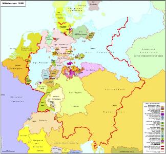
Mitteleuropa 1949
Mitteleuropa Kunz, Andreas ; Treiling, Thomas
Deutschland Politische Uebersicht
Plastischer Schul-Atlas über alle Theile der Erde : in 24 Karten Woldermann, G Verlag von P. Eckerlein
Deutschland
Schul-Atlas in 36 Karten Völter, Daniel Verlag der J.M. Dannheimer'schen Buchhandlung
Deutschland, Übersicht der Politischen Eintheilung
Hand-Atlas über alle Theile der Erde und über das Weltgebäude Stieler, Adolf Justus Perthes

Mitteleuropa 1989
Mitteleuropa Kunz, Andreas ; Treiling, Thomas