Maps of Pontic Steppe

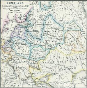
Russland von der Zerstörung Kiews durch Batu, 1240, bis zum Übergang des Grossfürstenthums nach Moskau
1 : 15000000 Russland
Russland nach seinen kirchlichen Verhältnissen bis zum XVI. Jahrhundert
1 : 15000000 Russland Kirchengeschichte
Karta želěznych dorog Rossijskoj imperiji
1 : 1200000 Moskva-oblast (Rusko) izdanije Kartografičeskago zavedenija A. Il'jina
Russia in Europe.
1 : 11000000 Darton, William
Uebersicht über die Stabsquartiere der russischen Armee
Russland Militär
Russland von der Besiegung der Petschenegen durch die Polowzer und der Erweiterung der Nowgorodischen Republik nach Nordosten, um 1114 bis zur Zerstörung Kiew's durch die Tataren 1240
1 : 12000000 Weliki Nowgorod, Kiewer Reich
Karte des europaeischen Russlands
1 : 15000000 1 Karte : Kupferdruck ; 21 x 18 cm Walch, Johann bei Joh. Walch
Partie de l'Empire de Russie comprise en Europe
1 : 6500000 par le Sr. d'Anville [S.l.] : [s.n.]
Russia in Europe.
1 : 8400000 Sharpe, J.
[Neuer Atlas der ganzen Erde nach den neuesten Bestimmungen ... : XXII.] Charte von dem Europaeisch-Russischen Reiche
Entworfen u. gezeichnet von Dr. F.W. Streit H. Leutemann sc. Leipzig : J.C. Hinrichssche Buchhandlung
Das Europaeische Russland
Russland / Europäischer Teil
Russland von der Verlegung des Russischen Grossfürstenthums nach Moskau 1328 und der Gründung des Grossfürstenthums Litauen bis zur Vernichtung der Goldenen Horde 1480
1 : 21000000 Moskauer Reich, Großfürstentum Litauen
Russia in Europe.
1 : 12000000 Tanner, Henry S.
Das europaische Russland
1 : 6588000 Petrohrad-oblast (Rusko) Weiland, Karl Ferdinand im Verlage des Geogr. Instituts
Das europaeische Russland
1 : 6588000 Petrohrad-oblast (Rusko) Weiland, Karl Ferdinand im Verlage des Geogr. Instituts
Ruszland, Regenmenge u. Januar-Jsothermen
Russland / Europäischer Teil Pflanzenbau, Klima
Das europaeische Russland
1 : 6588000 Rusko západní Weiland, Karl Ferdinand Geograph. Institut
Map illustrating ancient Russian history
Russland Kiewer Reich Philip, George ; Philip, [Sohn v. G.]
Russland von der Verlegung des Russischen Grossfürstenthums nach Moskau, 1328, und der Gründung des Grossfürstenthums Litthauen bis zur Vernichtung der Goldenen Horde, 1480
1 : 12000000 Großfürstentum Litauen, Moskauer Reich
Schematičeskaja karta uězdov evropejskoj Rossīi. Urožaja rži "sam " za 1885 g.
Russland Russland Landwirtschaft Statistik Petrovskij, A.N.
Anbau u. Juli-Jsothermen
Russland / Europäischer Teil Pflanzenbau, Klima

Ethnographische Übersichtskarte von Osteuropa
1 : 10000000 Russland Ukraine Ethnische Gruppe Kartogr. Anstalt G. Freytag & Berndt, Ges. m. b. H., Wien
Karta rossijskich želěznych dorog
1 : 5250000 Charkov-oblast (Ukrajina) Bangof, Eduard v artističeskom zavedenija A.F. Marksa
Schematičeskaja karta uězdov evropejskoj Rossīi. Urožaja ovsa "sam " za 1885 g.
Russland Russland Landwirtschaft Statistik Petrovskij, A.N.
Charte von dem europaeisch Russischen Reiche
1 : 7400000 Rusko západní Kipferling, Karl Joseph J. Riedl's Kunsthandlung
Charte von dem europaeisch Russischen Reiche
1 : 7400000 Rusko západní Kipferling, Karl Joseph J. Riedl's Kunsthandlung
Charte von dem europaeisch Russischen Reiche
1 : 7400000 Rusko západní Kipferling, Karl Joseph Kunst und Industrie Comptoirs
Carte de la partie européenne de l'empire de Russie, avec l'indication des chemins de poste, ainsi que des douanes frontières et de la repartition actuelle en gouvernements et districts
1 : 3000000