Maps of powiat tarnowski

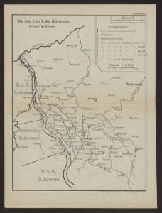
Die vom 2. bis 7. Mai 1915 abends erreichten Linien
1 : 515000 Polen Tarnów Weltkrieg <1914-1918> Verl. Gerhard Stalling, Oldenburg
Vom Dunajec bis zum Wislok
1 : 160000 Polen Dunajec-Gebiet Weltkrieg <1914-1918> Verl. Gerhard Stalling, Oldenburg
Reliefkarte Gorlice-Tarnów
Polen Tarnów Weltkrieg <1914-1918> Verl. Gerhard Stalling, Oldenburg
Sanok 108, uit: Special-Karte von Mittel-Europa / nach amtlichen Quellen bearbeitet von W. Liebenow
1 : 300000 titelvariant: W. Liebenow's Mittel-Europa; Annotatie: Titel boven de bladen: W. Liebenow's Mittel-Europa Johannes Wilhelm Liebenow 1822-1897 Frankfurt a. M. : Ludwig Ravenstein
Crybow und Corlice.
from Spezialkarte der osterreichisch-ungarischen Monarchie.
Jaslo und Dukla.
from Spezialkarte der osterreichisch-ungarischen Monarchie.
Tarnow und Dabrowa.
from Spezialkarte der osterreichisch-ungarischen Monarchie.
Ropczyce und Debica.
from Spezialkarte der osterreichisch-ungarischen Monarchie.
Brzostek und Strzyzow.
from Spezialkarte der osterreichisch-ungarischen Monarchie.
Pilzno und Ciezkowice.
from Spezialkarte der osterreichisch-ungarischen Monarchie.
Tarnów und Dąbrowa
1 : 75000 Dąbrowa Tarnowska-oblast (Polsko) Ansion K. u. k. Militärgeographisches Institut
Ropczyce und Debica
1 : 75000 Dębica (Polsko) Jersche K. u. k. Militärgeographisches Institut
Jasło und Dukla
1 : 75000 Jasło-oblast (Polsko) Höller, K. K. u. K. militär- geographisches Institut
Brzostek
1 : 75000 Brzostek, Woiwodschaft Vorkarpaten
Pilzno und Cieżkowice
1 : 75000 Pilzno-oblast (Polsko) Grob, R. K. u. k. Militärgeographisches Institut
Mielec und Majdan
1 : 75000 Polsko Matskássy K. u. k. militär-geographisches Institut
Mielec und Majdan.
from Spezialkarte der osterreichisch-ungarischen Monarchie.
Szczucin.
from Spezialkarte der osterreichisch-ungarischen Monarchie.
Szczucin
1 : 75000 Rogulja K. u. k. Militärgeographisches Institut
III. vojenské mapování 4266
1 : 75000
Bartfa und Muszyna.
from Spezialkarte der osterreichisch-ungarischen Monarchie.
Dukla-Pasz (Galizien).
from Spezialkarte der osterreichisch-ungarischen Monarchie.
Brzostek und Strzyżów
1 : 75000 Polsko Charlemont K. u. k. militär-geographisches Institut
Grybów und Gorlice
1 : 75000 Gorlice (Polsko) Leitner K. u. k. Militärgeographisches Institut
Jasliśka NW
1 : 25000 Polsko Reichsamt für Landesaufnahme
[Gradkartenblatt]
1 : 25000 Polsko Vojenský zeměpisný ústav
[Gradkartenblatt]
1 : 25000 Slovensko Vojenský zeměpisný ústav
Jasliśka NO
1 : 25000 Polsko Reichsamt für Landesaufnahme
[Gradkartenblatt]
1 : 25000 Slovensko Vojenský zeměpisný ústav