Maps of Balkan Pen.
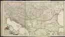
[79][79]Regni Hungariae, ..., uit: Atlas sive Descriptio terrarum orbis
Annotatie: Gedigitaliseerde versie. Amsterdam. Heiloo : Picturae (vervaardiger), 2015. tiff-bestand. Gedigitaliseerd: 07-01-2015; Origineel: Universiteitsbibliotheek Vrije Universiteit (XL.05127.-) ; Netherlands; Titelpagina ontbreekt Wit, Frederik de Amsterdam : Frederick de Wit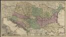
Novissima tabula regni Hungariae et regionum quondam ei unitarum ut Transilvaniae, Valachiae, Moldaviae, Serviae, Romaniae, Bulgariae, Bessarabiae, Croatiae, Bosniae, Dalmatiae, Slavoniae, Morlachiae et reipublicae Ragusanae : accedit pars magna dominii Veneti [...]
1 : 2000000 auctore Reinier & Josua Ottens geographe Amstelodamensi J. Keyser sculpsit Te Amsterdam : by Reinier & Iosua Ottens [...]
Österreich-Ungarn, Staatenkarte
1 : 4500000 Österreich-Ungarn
Österreich-Ungarn
1 : 4500000 Österreich-Ungarn
Südosteuropa mit den von 1919 bis 1938 geltenden Staatsgrenzen
Südosteuropa Grenzen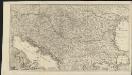
Novissima tabula regni Hungariae et regionum quondam ei unitarum ut Transilvaniae, Valachiae, Moldaviae, Serviae, Romaniae, Bulgariae, Bessarabiae, Croatiae, Bosniae, Dalmatiae, Slavoniae, Morlachiae et reipublicae Ragusanae : accedit pars magna dominii Veneti [...]
1 : 2000000 auctore Reinier & Josua Ottens geographe Amstelodamensi J. Keyser sculpsit Te Amsterdam : by Reinier & Iosua Ottens [...]
Marche des Ostrogoths à travers l’Europe méridionale
Mitteleuropa Ostgoten Völkerwanderungszeit Völkerwanderung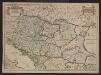
Le Royaume de Hongrie et les estats qui en esté sujets et qui sont presentement la partie septentrionale de la Turquie en Europe. Tiré des memoires les plus nouveaux
1 : 2100000 Ungarn, Südosteuropa Sanson, Guillaume
Oorlogskaart van Zuid-Oostelijk Europa : (Italië tot de Dardanellen)
1 : 2500000 Annotatie: Ondertitel op omslag: Italiaansch-Oostenrijksche grenzen, gebied der Adriatische Zee, Roemeensch-Hongaarsche grenzen, de Dardanellen Amsterdam : Van Holkema & Warendorf
Le Cours Du Danube Depuis sa Source Iusqu'a ses Embouchures [Karte] Le Bosphore De Thrace [...] [Nebenkarte], in: Atlas nouveau, contenant toutes les parties du monde [...], Bd. 1, S. 249.
1 Karte aus Atlas Sanson, Nicolas Jaillot, Alexis Hubert und Mortier, Pieter
CARTE DU COURS DU DANUBE depuis Ulm jusqu'a son embouchure dans la Mer noire
Dunaj (Rumunsko a Ukrajina : řeka : delta) Artaria & Compagnie
Ost-Europa, No. 5: Sud-West-Russland & die Turkei.
1 : 3700000 Petermann, A.
[Ost-Europa in 6 Blättern, Blatt 5]
Handatlas über alle Theile der Erde und über das Weltgebäude Stieler, Adolf Justus Perthes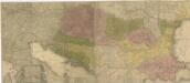
Carte geographique representant le théatre de la guerre entre les Russes, les Turcs, et les Polonis Confédérés ...

[Ost-Europa in 6 Blättern, Enthaltend: Norwegen, Schweden, Russland, Kaukasien und die Türkei, Blatt 5]
Hand-Atlas über alle Theile der Erde und über das Weltgebäude Stieler, Adolf Justus Perthes
Galizien, Ungarn mit Slavonien und Croatien, Siebenbürgen und Dalmatien, Moldau, Wallachey
Hand-Atlas über alle Theile der Erde nach dem neuesten Zustande und über das Weltgebäude Stieler, Adolf bei Justus Perthes
Homannův atlas světa
1 : 1900000
Le royaume de Hongrie et les estats qui ont esté vnis a sa couronne
1 : 2870000 Evropa jihovýchodní Jaillot, Alexis-Hubert H. Iaillot
Fluviorum in Europa principis Danubii Cum Adiacentibus Regnis, nec non totius Graeciae Et Archipelagi Novißima Tabula
Balkanhalbinsel, Donau, Flusslauf Homann, Johann Baptist
Regni Hungariae, Graeciae, et Moreae, ac regionum, quae ei quondam fuêre christiani, ut Transilvaniae, Valachiae, Moldaviae, Bessarabiae, Bosniae, Sclavoniae, Serviae, Bulgariae, Croatiae, Romaniae, Dalmatiae, Morlachiae, Ragusanae republicae, maximaeq partis Danubii fluminis novissima delineatio
1 : 4000000 1 Karte : Kupferdruck ; 49 x 57 cm Danckerts, Johannes [Danckerts]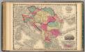
Austria Turkey In Europe And Greece.
1 : 4181760 Johnson, A.J.
Hungariae ampliori significatu...

Danvbivs & Ister cum Dominio Turcico in Europa et adjacentibus Regionibus descriptus a fonte ad Ostia
1 : 5900000 Mollova mapová sbírka Weigel, Christoph Kauffer, Michael Weigel, Christoph I.
A sea chart of the Gulph of VENICE describing all the sea coasts and Islands contained therein
from The sea-atlas : containing an hydrographical description of most of the sea-coasts of the known parts of the world.
Accurate Landkarte Des Königreichs Hungarn des Fürstenthümer Siebenbürge; Moldau und Wallachey, wie auch Griechenlandes und Morea Samt dem Weltberüffnene Donau-Throm
1 : 4000000 Mollova mapová sbírka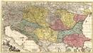
Theatrum Belli Russo-Turcici.
1 : 2100000 Mollova mapová sbírka Probst, Johann Michael Probst, Johann Michael
Estats de l'Empire des Turqs en Europe
1 : 4190000 Evropa jihovýchodní Sanson, Guillaume Schenk, Pieter Pierre Schenk
Der Balkan
1 : 2000000 Velhagen & Klasing. Firm Bielefeld : Velhagen & Klafing

![[79][79]Regni Hungariae, ..., uit: Atlas sive Descriptio terrarum orbis](https://images-2.georeferencer.com/images/iiif/758983808901/full/,300/0/native.jpg)

