Maps of Balkan Pen.

Maps of Balkan Pen.

$title$

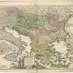
Homannův atlas světa

1 : 1900000
$title$

Fluviorum in Europa principis Danubii Cum Adiacentibus Regnis, nec non totius Graeciae Et Archipelagi Novißima Tabula

Balkanhalbinsel, Donau, Flusslauf Homann, Johann Baptist
$title$

$title$

Austria, Turkey in Europe, and Greece.

1 : 3920000 Johnson, A.J.
$title$

Austria, Turkey in Europe, and Greece.

1 : 3920000 Johnson, A.J.
$title$

Regni Hungariae, Graeciae, et Moreae, ac regionum, quae ei quondam fuêre christiani, ut Transilvaniae, Valachiae, Moldaviae, Bessarabiae, Bosniae, Sclavoniae, Serviae, Bulgariae, Croatiae, Romaniae, Dalmatiae, Morlachiae, Ragusanae republicae, maximaeq partis Danubii fluminis novissima delineatio

1 : 4000000 1 Karte : Kupferdruck ; 49 x 57 cm Danckerts, Johannes [Danckerts]
$title$

Totius Danubii cum adjacentibus regnis nec non totius Graeciae et Archipelagi novissima tabula

1 : 3900000 Dunaj-oblast August, Gottlob Dorn, Sebastian cura Homannianorum Heredum
$title$

16 bis. Europa etnografica.

1 : 6000000 Touring club italiano
$title$

Italy, Turkey, Greece, Europe.

Goodrich, S.G.
$title$

[Central and southeast Europe]

Evropa jihovýchodní
$title$

Estats de l'Empire des Turqs en Europe

1 : 4190000 Evropa jihovýchodní Sanson, Guillaume Schenk, Pieter Pierre Schenk
$title$

DDAC-Karte von Südosteuropa

1 : 2000000 Evropa jihovýchodní Der Deutsche Automobil-Club
$title$

Der Balkan

1 : 2000000 Velhagen & Klasing. Firm Bielefeld : Velhagen & Klafing
$title$

Wichtige Handelswege im späten Mittelalter

Südosteuropa Handelsstraße Zwick, J.
$title$

[LL.03949gk: 100/od/1943], uit: Kompas van Italië en Zuid-Oost Europa

1 : 3500000 Annotatie: Ook op de kaart: Tom Tas van Kompas; Vrijgegeven door W.B.N. [Wehrmachts Bereich in den Niederlanden] 30.10.'43; Grenzen van 1 sept. 1939; Op verso: incompleet gedeelte van wat waarschijnlijk poster is geweest, met tekst: Oranje Boot, half om half Den Haag : Kompas
$title$

Fluviorum in Europa principis Danubii cum Adiacentibus Regnis nec non totius Graeciae et Archipelagi Novißima Tabula

1 : 4100000 Mollova mapová sbírka Homann, Johann Baptist Homann, Johann Baptista
$title$

Karte von dem Osmanischen Reiche in Europa

$title$

Austria Turkey In Europe And Greece.

1 : 4181760 Johnson, A.J.
$title$

[Turcia Evropaea] qua maxima pars Danubii et praesertim Hungaria

1 : 4000000 Achaia (Řecko) Seutter, Matthäus a Matthaeo Seutter
$title$

Totius Danubii nova & accuratiss. tabula, universam simul Turciam Europaeam, Hungariam magnam Germaniae partem, totam pene Italiam, atque una Moream cum Sicilia et Candia complectens

1 : 3000000 auctore Jacobo de la Feuille [Amsterdam], Jacobo de la Feuille
$title$

[Historisch-geographischer Atlas zu den allgemeinen Geschichtswerken von C. v. Rotteck, Pölitz u. Becker] : Italien eine Uebersicht seiner Völker und Staaten in der ältesten Zeit

von Julius Loewenberg Lithographie von B. Herder in Freiburg im Breisgau [Freiburg im Breisgau] : [Herder]
$title$

Südosteuropa um 1570

Südosteuropa, Osmanisches Reich, Verwaltungsgliederung Zwick, J. ; Koller, M. ; Kreuter, P. M.
$title$

Austria, Turkey in Europe, and Greece.

1 : 3920000 Johnson, A.J.
$title$

Danvbivs & Ister cum Dominio Turcico in Europa et adjacentibus Regionibus descriptus a fonte ad Ostia

1 : 5900000 Mollova mapová sbírka Weigel, Christoph Kauffer, Michael Weigel, Christoph I.
$title$

Turkey

1 : 6437376 Shows the Balkan Peninsula Relief shown by landforms. Language: English Place of publication not identified : publisher not identified
$title$

Fluviorum in Europa principis Danubii

1 : 4100000 Mollova mapová sbírka Homann, Johann Baptist Homann, Johann Baptista - dědici
$title$

[Kaart], uit: Der Thüringerwald

1 : 150000 Annotatie: Verso: informatie [S.l. : Shell Reisedienst]
$title$

Südosteuropa 1992

Südosteuropa, Balkanhalbinsel Kunz, Andreas ; Treiling, Thomas ; Moeschl, Joachim
$title$

Tabula Europae IX. [Karte], in: Claud. Ptolemaeus. Geographia lat. cum mappis [...], S. 278.

1 Karte aus Atlas Münster, Sebastian [und Ptolemaeus, Claudius]
$title$

Völkerkarte von Mittel-und Südosteuropa

1 : 15000000 Mitteleuropa, Südosteuropa, ethnische Gruppe
© MapTiler © OpenStreetMap contributors
How does it work?
These instructions will show you how to find historical maps online.
Getting started
Type the place name in the search box to find the exact location. You can further adjust the search by zooming in and out.
Zoom
Zoom in and out with the buttons or use your mouse or touchpad natively.
Exact Area tool
Click here and draw a rectangle over the map to precisely define the search area.
Set filters
Narrow your search with advanced settings, such as Years (from/to), Fulltext, Publisher, etc.
Results
See the results of your search on the right side. You can scroll down to find more maps of this location.
?

Download OldMapsOnline Mobile