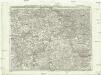
Maps of Rhein-Sieg-Kreis

[Kaart], uit: Kleines Relief-Panorama des Rheines
titelvariant: Kleines farbiges Relief-Panorama des Rheines; Annotatie: Titel op omslag: Kleines farbiges Relief-Panorama des Rheines; Met ill. van bezienswaardigheden aan weerszijden van de kaart Köln am Rhein : Hoursch & Bechstedt
Département de Rhin et Moselle
1 : 270000 Mosela, řeka-oblast Chanlaire, P. G. chez P.G. Chanlaire
[Kaart], uit: Relief-Panorama des Rheines
titelvariant: Rhein Panorama von Mainz bis Köln; Annotatie: Omslagtitel: Rhein Panorama von Mainz bis Köln Köln-Ehrenfeld : Hoursch & Bechstedt
[Kaart], uit: Rheinlauf von Mainz bis Köln : mit seitlicher Beschreibung
Annotatie: Met beschrijving en ill. van bezienswaardigheden aan weerszijden van de kaart Köln : Bremer

Théatre de la Guerre ou Carte Nouvelle De le Cours du Rhin depuis Worms jusqu'a Bonne et Les Pays Adjacens
1 : 250000 Mollova mapová sbírka Delisle, Guillaume Ottens, Josua
Der Rhein von Mainz bis Cöln
Kolín nad Rýnem (Německo) Kapp, D. Verlag von D. Kapp
Partie Orientale Du Temporel De L'Archevesché et Eslectorat De Treves. [Karte], in: Atlas nouveau, contenant toutes les parties du monde [...], Bd. 1, S. 200.
1 Karte aus Atlas Sanson, Nicolas Jaillot, Alexis Hubert und Mortier, Pieter
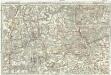
Le Cours du Rhin depuis Worms, jusqu'a Bonne et les Pays Adjacens
1 : 240000 Mollova mapová sbírka Delisle, Guillaume Liébaux L'Isle, Guillaume de
Militair Karte von Süd-Deutschland in 20 Sectionen
1 : 400000 1. Section Coulon, Alois von A. von Coulon
Cursus Rheni a Basilea usque ad Archi-Episcopatum Coloniensem :
1 : 2900000 Mollova mapová sbírka Seutter, Matthäus Seutter, Matthäus
Archiepiscopatus et Electoratus Trevirensis Novissima delineatio
1 : 310000 Mollova mapová sbírka Wit, Frederik de Wit, Frederick
Mosella et Rheni Confluxus
Mollova mapová sbírka Person, Nikolaus Person, Nicolas
Nassoviae Principatus et ad cum spectantes Ditiones
1 : 180000 Mollova mapová sbírka Seutter, Matthäus Seutter, Matthäus
Partie Orientale Du Temporel De L'Archevesché et Eslectorat, De Treves
1 : 210000 Mollova mapová sbírka Sanson, Guillaume Jaillot, Alexis Hubert
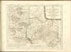
Carte topographique tres exacté de la Wetteravie
1 : 220000 Hesensko (Německo) Coentgen, Heinrich Hugo chez I.W.A. Iaeger
Carte topographique tres exacté de la Wetteravie
1 : 220000 Hesensko (Německo) Jaeger, Johann Wilhelm Abraham I. W. A. Jaeger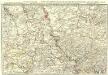
Exactissima totius Vederoviae laté sumtae Tabula
1 : 210000 Mollova mapová sbírka Buna, Wilhelm C. Broenner, Heinrich Ludwig
Partie Septentrionalo Des Pays qui sont situéz Entre le Rhein, la Saare, la Moselle, et la Basse Alsace. [Karte], in: Atlas nouveau, contenant toutes les parties du monde [...], Bd. 1, S. 238.
1 Karte aus Atlas Sanson, Nicolas Jaillot, Alexis Hubert und Mortier, Pieter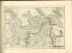
Tractus Hunnorum tabula exactissima, proponens maximam partem Sylvae olim dictae Arduenna, elect. Mogunt. Palat. ad Rhenum, et Trevir. princip. et com. Cattimelib. infer. Nassov. cum adjac. comit. et regionibus intra Rhenum, Mosellam, Saramque, secundum exactissimae vederoviae
Ardeny Buna, Wilhelm C.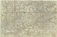
[Poříčí Mosely]
Mosela, řeka-oblast Buna, Wilhelm C.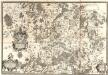
Dioecesis Trevirensis Tractvs Mosellanvs Inferior
1 : 50000 Mollova mapová sbírka Person, Nikolaus Person, Nicolas
Partie Orientale du Temporel, de l'Archevesché et Eslectorat de Treves
1 : 220000 Mollova mapová sbírka Sanson, Guillaume Jaillot, Alexis Hubert
Mosellauf von Koblenz bis Trier : mit seitlich angebrachtem Führer
Annotatie: Op omslag: Nr. 28 Da; Met beschrijving van bezienswaardigheden aan weerszijden van de kaart Köln : Bremer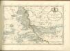

Partie Occidentale du Palatinat et Eslectorat du Rhein
1 : 125000 Mollova mapová sbírka Sanson, Guillaume Jaillot, Alexis Hubert
![[Kaart], uit: Kleines Relief-Panorama des Rheines](https://images-2.georeferencer.com/images/iiif/105320463878/full/,300/0/native.jpg)

