Maps of Regierungsbezirk Gießen
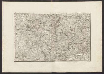
Militair Karte von Süd-Deutschland in 20 Sectionen
1 : 400000 1. Section Coulon, Alois von A. von Coulon
Generalkarte von Zentraleuropa

6) III.E. ''Cologne'', uit: Carte géologique de France
1 : 500000 Annotatie: Voor aanwezige bladen zie bladoverzicht [S.l : s.n.]
Nassovia Comitatus. [Karte], in: Novus Atlas, das ist, Weltbeschreibung, Bd. 1, S. 273.
1 Karte aus Atlas Blaeu, Joan Blaeu, Willem Janszoon
Nassovia Comitatus [Karte], in: Novus atlas absolutissimus, Bd. 2, S. 162.
1 Karte aus Atlas Janssonius Offizin
Nassovia comitatus / Salomon Rogiers sculpsit ; Guiljelm. Blaeuw excudit
1 : 300000 Annotatie: Origineel is Blad 104 in atlas factice; Annotatie geografische gegevens: Schaalstokken op de kaart: Miliaria Germanica communia, en: Horae itineris Salomon Rogiers ca 1592- v. 1640; Willem Jansz Blaeu 1571-1638 Amstelodami : Guiljelm. Blaeuw
Nassovia Comitatus. [Karte], in: Theatrum orbis terrarum, sive, Atlas novus, Bd. 1, S. 254.
1 Karte aus Atlas Blaeu, Joan Blaeu, Willem Janszoon
[Kaart], uit: Rheinlauf von Mainz bis Köln : mit seitlicher Beschreibung
Annotatie: Met beschrijving en ill. van bezienswaardigheden aan weerszijden van de kaart Köln : Bremer
Nassovia Comitatus [Karte], in: Gerardi Mercatoris et I. Hondii Newer Atlas, oder, Grosses Weltbuch, Bd. 1, S. 200.
1 Karte aus Atlas Mercator, Gerhard und Hondius, Jodocus Jansson, Jan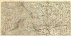
Du Haut Rhin ou sont L'Archevesché et Electorat de Treves, Partie de Ceux de Mayence et de Cologne de Treves de Mont Royal de Coblens de Mayence et de Franckfort levé sur les lieux pendt. les guerres
1 : 250000 Mollova mapová sbírka Jaillot, Alexis-Hubert Jaillot, Alexis Hubert
[Kaart], uit: Rheinlauf von Mainz bis Köln
Annotatie: Met beschrijving en ill. van bezienswaardigheden aan weerszijden van de kaart Köln : Bremer
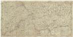
Neue general Kriegs Karte des Rheinstrohms
1 : 261000 Kolín nad Rýnem (Německo) Walch, Johann Iohann Walch im Willischen Kunstverlag
Neue general Kriegs Karte des Rheinstrohms
1 : 261000 Kolín nad Rýnem (Německo) Walch, Johann Iohann Walch im Willischen Kunstverlag
Herzogthum Nassau, Landgrafschaft Hessen Homburg und die Freie Stadt Frankfurt
Grosser Hand-Atlas über alle Theile der Erde in 170 Karten Meyer, J. Verlag des Bibliographischen Instituts
Le Cours du Rhin depuis Worms, jusqu'a Bonne et les Pays Adjacens
1 : 240000 Mollova mapová sbírka Delisle, Guillaume Liébaux L'Isle, Guillaume de
NASSOVIA | Comitatus
Salomon Rogiers sculpsit [Amsterdam : Joan Blaeu]
Partie Orientale Du Temporel De L'Archevesché et Eslectorat De Treves. [Karte], in: Atlas nouveau, contenant toutes les parties du monde [...], Bd. 1, S. 200.
1 Karte aus Atlas Sanson, Nicolas Jaillot, Alexis Hubert und Mortier, Pieter
Das Herzogthum Nassau
1 : 438000 Weimar : Verlag des Geographischen Instituts
Parties des estats de s cercles des quatre electeurs et du Haut Rhin ou sont l'archevesché et electorat de Treves, partie de ceux en Mayence et de Cologne les estats de Wetteravie et de Hesse Darmstatt ou sont les environs des villes de Treves de Mont Royal de Coblens de Mayence et de Franckfort levé sur les lieux pend.t les guerres
1 : 200000 Darmstadt (Německo) Sengre, Henri Jaillot, Alexis-Hubert Iaillot
Le Cours du Rhin depuis Worms, jusqua Bonne et les pays adjace[nt]s
L'Isle, Guillaume de; Buache, Philippe Dezauche
Herzogthum Nassau
1 : 538200 Nasavsko Hoeckner, Carl aus der Schweinfurten Geographischen Gravirsanstalt des Bibliographischen Instituts
Sheet 2, uit: Stanford's large scale map of the seat of war / Stanford's Geographical Estab[lishmen]t
1 : 300000 Stanford's Geographical Establishment, Londen London : Stanford
Cursus Rheni a Basilea usque ad Bonnam, III. sectionibus exhibitus
1 : 258000 Basilej (Švýcarsko) Delisle, Guillaume Homannianos Heredes
[Kaart], uit: Relief-Panorama des Rheines
titelvariant: Rhein Panorama von Mainz bis Köln; Annotatie: Omslagtitel: Rhein Panorama von Mainz bis Köln Köln-Ehrenfeld : Hoursch & Bechstedt
Cursus Rheni a Basilea Usque Ad Archi-Episcopatum Coloniensem

Département de Rhin et Moselle
1 : 270000 Mosela, řeka-oblast Chanlaire, P. G. chez P.G. Chanlaire
Le Theatre de Bellone :
Mollova mapová sbírka Schenk, Pieter Braakman, Adriaan
Der Rhein von Mainz bis Cöln
Kolín nad Rýnem (Německo) Kapp, D. Verlag von D. Kapp