Maps of Rees

Bl. 27 Aalten, 1907, uit: Atlas A.N.W.B.
1 : 200000 titelvariant: Atlas van Nederland van den A.N.W.B. Toeristenbond voor Nederland; Wielrijders-atlas van Nederland; Annotatie: Titel op bladwijzer: Atlas van Nederland van den A.N.W.B. Toeristenbond voor Nederland; Titel op legendablad: Wielrijders-atlas van Nederland; Voor aanwezige bladen zie overzichtsblad; Annotatie geografische gegevens: De serie bestaat uit 36 bladen ANWB ['s-Gravenhage : A.N.W.B.]
Bl. 27 Aalten, 1904, uit: Atlas A.N.W.B.
1 : 200000 titelvariant: Atlas van Nederland van den A.N.W.B. Toeristenbond voor Nederland; Wielrijders-atlas van Nederland; Annotatie: Titel op bladwijzer: Atlas van Nederland van den A.N.W.B. Toeristenbond voor Nederland; Titel op legendablad: Wielrijders-atlas van Nederland; Voor aanwezige bladen zie overzichtsblad; Annotatie geografische gegevens: De serie bestaat uit 36 bladen ANWB ['s-Gravenhage : A.N.W.B.]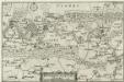
Ducatus Cliviae Pars
1 : 150000 Mollova mapová sbírka Person, Nikolaus Person, Nicolas
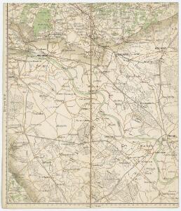
North Rhine-Westphalia 1945
7 Survey Regiment RA - Rhine Crossing : map shewing regimental dispositions and information obtained (other than AA). SA/Misc/4243. Great Britain. Army. Royal Regiment of Artillery. Survey Regiment, 7th. [S.l.] : 7 Survey Regiment RA
14de blad, uit: Topographische kaart van de provincie Gelderland / vervaardigd door W. Kuyk Jzn. ; op steen gegrav. door A. Bayly en J.M. Huart ; gelithogr. door J.M. Huart
1 : 50000 titelvariant: Kaart der provincie Gelderland; Annotatie: Omslagtitel: Kaart der provincie Gelderland; Vervaardigd in opdracht van de Staten van Gelderland; Met register van trigonometrische punten (bl. 4) en bladwijzer (bl. 5) W. Kuyk Jzn fl. 1843; Bayly, A.; Huart, J. M. [S.l. : s.n.]
Germany 1:25,000, Anholt
Germany 1:25,000 , Series GSGS 4414. Great Britain. War Office. [London] : War Office
Germany 1:25,000, Emmerich
Germany 1:25,000 , Series GSGS 4414. Great Britain. War Office. [London] : War Office
Germany 1:25,000, Bocholt
Germany 1:25,000 , Series GSGS 4414. Great Britain. War Office. [London] : War Office
Germany 1:25,000, Xanten
Germany 1:25,000 , Series GSGS 4414. Great Britain. War Office. [London] : War Office
Germany 1:25,000, Udem
Germany 1:25,000 , Series GSGS 4414. Great Britain. War Office. [London] : War Office
Germany 1:25,000, Calcar
Germany 1:25,000 , Series GSGS 4414. Great Britain. War Office. [London] : War Office
Germany 1:25,000, Wesel
Germany 1:25,000 , Series GSGS 4414. Great Britain. War Office. [London] : War Office
Germany 1:25,000, Dingden
Germany 1:25,000 , Series GSGS 4414. Great Britain. War Office. [London] : War Office
Germany 25.000, Bocholt
Sheet 4105 from the map series: Germany 1 : 25,000. AMS M 841. (GSGS. 4414). [Washington, D.C.] : Army Map Service
Meßtischblatt 2427 : Wesel, 1914
1 : 250000 Wesel. - Aufn. 1892, hrsg. 1893, Aufl.-dr. 1914. - 1:25000. - [Berlin]: Reichsamt für Landesaufnahme, 1914. - 1 Kt.
Meßtischblatt 2426 : Xanten, 1906
1 : 250000 Xanten. - Aufn. 1892, hrsg. 1894, bericht. 1906. - 1:25000. - [Berlin]: Reichsamt für Landesaufnahme, 1906. - 1 Kt.
Meßtischblatt 2425 : Üdem, 1907
1 : 250000 Üdem. - Aufn. 1892, hrsg. 1894, bericht. 1907. - 1:25000. - [Berlin]: Reichsamt für Landesaufnahme, 1907. - 1 Kt.
Meßtischblatt 2354 : Dingden, 1926
1 : 250000 Dingden. - Aufn. 1895, bericht. 1926. - 1:25000. - [Berlin]: Reichsamt für Landesaufnahme, 1926. - 1 Kt.
Meßtischblatt 2354 : Dingden, 1897
1 : 250000 Dingden. - Aufn. 1895. - 1:25000. - [Berlin]: Reichsamt für Landesaufnahme, 1897. - 1 Kt.
Meßtischblatt 2353 : Rees, 1926
1 : 250000 Rees. - Aufn. 1895, bericht. 1926. - 1:25000. - [Berlin]: Reichsamt für Landesaufnahme, 1926. - 1 Kt.
Meßtischblatt 2352 : Calcar, 1926
1 : 250000 Calcar. - Aufn. 1892, bericht. 1926. - 1:25000. - [Berlin]: Reichsamt für Landesaufnahme, 1926. - 1 Kt.
Meßtischblatt 2352 : Calcar, 1914
1 : 250000 Calcar. - Aufn. 1892, hrsg. 1894, Aufl.-dr. 1914. - 1:25000. - [Berlin]: Reichsamt für Landesaufnahme, 1914. - 1 Kt.
Meßtischblatt 2207/2280 : Bocholt, 1910
1 : 250000 Bocholt. - Aufn. 1895. - 1:25000. - [Berlin]: Reichsamt für Landesaufnahme, 1910. - 1 Kt.
Meßtischblatt 2207/2280 : Bocholt, 1897
1 : 250000 Bocholt. - Aufn. 1895. - 1:25000. - [Berlin]: Reichsamt für Landesaufnahme, 1897. - 1 Kt.
Meßtischblatt 2279 : Anholt, 1907
1 : 250000 Anholt. - Aufn. 1895, bericht. 1907. - 1:25000. - [Berlin]: Reichsamt für Landesaufnahme, 1897. - 1 Kt.
Meßtischblatt 2206/2278 : Emmerich, 1914
1 : 250000 Emmerich. - Aufn. 1895, hrsg. 1896, Aufl.-dr. 1914. - 1:25000. - [Berlin]: Reichsamt für Landesaufnahme, 1914. - 1 Kt.
Meßtischblatt 2206/2278 : Emmerich, 1896
1 : 250000 Emmerich. - Aufn. 1895, hrsg. 1896. - 1:25000. - [Berlin]: Reichsamt für Landesaufnahme, 1896. - 1 Kt.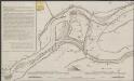
Caarte van de rivieren ontrent Schenkenschans met de geconcipieerde doorsnydinge over 't Spijk ...
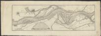
Kaart van de Bylandsche Waard, het benedenste gedeelte van den Boven Rhyn, Whaal en Pannerdensche Canaal, derzelver oude strangen en oevers, aanschietende grind- en zand-wellen, waarden, kribben, enz.
1 : 25000 gemeeten door de landmeeters Fred.k en Mart.s Beyerinck, en door de landmeeters D. Klinkenberg en H. van Straalen overgebragt, naar welke laatste deeze is verkleind van 31/70 Leon.d Schenk Jansz. sculpsit 1779. [S.l.] : [s.n.]