Maps of Xanten

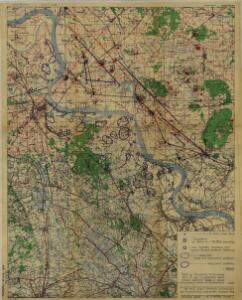
North Rhine-Westphalia 1945
7 Survey Regiment RA - Rhine Crossing : map shewing regimental dispositions and information obtained (other than AA). SA/Misc/4243. Great Britain. Army. Royal Regiment of Artillery. Survey Regiment, 7th. [S.l.] : 7 Survey Regiment RA
Germany 1:25,000, Wesel
Germany 1:25,000 , Series GSGS 4414. Great Britain. War Office. [London] : War Office
Germany 1:25,000, Dingden
Germany 1:25,000 , Series GSGS 4414. Great Britain. War Office. [London] : War Office
Meßtischblatt 2427 : Wesel, 1914
1 : 250000 Wesel. - Aufn. 1892, hrsg. 1893, Aufl.-dr. 1914. - 1:25000. - [Berlin]: Reichsamt für Landesaufnahme, 1914. - 1 Kt.
Meßtischblatt 2354 : Dingden, 1926
1 : 250000 Dingden. - Aufn. 1895, bericht. 1926. - 1:25000. - [Berlin]: Reichsamt für Landesaufnahme, 1926. - 1 Kt.
Meßtischblatt 2354 : Dingden, 1897
1 : 250000 Dingden. - Aufn. 1895. - 1:25000. - [Berlin]: Reichsamt für Landesaufnahme, 1897. - 1 Kt.
Germany 1:25,000, Xanten
Germany 1:25,000 , Series GSGS 4414. Great Britain. War Office. [London] : War Office
Meßtischblatt 2426 : Xanten, 1906
1 : 250000 Xanten. - Aufn. 1892, hrsg. 1894, bericht. 1906. - 1:25000. - [Berlin]: Reichsamt für Landesaufnahme, 1906. - 1 Kt.
Meßtischblatt 2353 : Rees, 1926
1 : 250000 Rees. - Aufn. 1895, bericht. 1926. - 1:25000. - [Berlin]: Reichsamt für Landesaufnahme, 1926. - 1 Kt.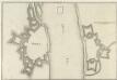
Rhees
Mollova mapová sbírka Merian, Caspar Merian, Caspar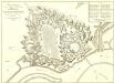
Plan Veritable de la Ville et Citadelle de Wesel
1 : 2900 Mollova mapová sbírka Le Rouge, Georges-Louis Martinet Le Rouge, Georges-Louis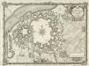
Plan de la Ville et Citadelle de Wesel En Westphalie
1 : 9000 Mollova mapová sbírka Martinet, G. Le Rouge, Georges-Louis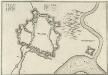
Weesell
Mollova mapová sbírka Merian, Caspar Merian, Caspar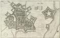
Nider Wesel
1 : 7000 Mollova mapová sbírka Merian, Matthaeus Merian, Matthäus
VESALIA | Vulgo | WESEL.
[Amsterdam : Joan Blaeu]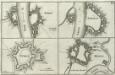
Rhees.
1 : 2800 Mollova mapová sbírka Person, Nikolaus Person, Nicolas
RHEES : [fortification plan].
[Amsterdam : Joan Blaeu]
BVRICK : [fortification plan].
[Amsterdam : Joan Blaeu]
Bl. 27 Aalten, 1904, uit: Atlas A.N.W.B.
1 : 200000 titelvariant: Atlas van Nederland van den A.N.W.B. Toeristenbond voor Nederland; Wielrijders-atlas van Nederland; Annotatie: Titel op bladwijzer: Atlas van Nederland van den A.N.W.B. Toeristenbond voor Nederland; Titel op legendablad: Wielrijders-atlas van Nederland; Voor aanwezige bladen zie overzichtsblad; Annotatie geografische gegevens: De serie bestaat uit 36 bladen ANWB ['s-Gravenhage : A.N.W.B.]
Bl. 27 Aalten, 1907, uit: Atlas A.N.W.B.
1 : 200000 titelvariant: Atlas van Nederland van den A.N.W.B. Toeristenbond voor Nederland; Wielrijders-atlas van Nederland; Annotatie: Titel op bladwijzer: Atlas van Nederland van den A.N.W.B. Toeristenbond voor Nederland; Titel op legendablad: Wielrijders-atlas van Nederland; Voor aanwezige bladen zie overzichtsblad; Annotatie geografische gegevens: De serie bestaat uit 36 bladen ANWB ['s-Gravenhage : A.N.W.B.]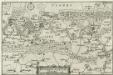
Ducatus Cliviae Pars
1 : 150000 Mollova mapová sbírka Person, Nikolaus Person, Nicolas
328. Bocholt.
1 : 100000 Reichsamt fur Landesaufnahme
Germany 1:25,000, Rheinburg
Germany 1:25,000 , Series GSGS 4414. Great Britain. War Office. [London] : War Office
Germany 1:25,000, Issum
Germany 1:25,000 , Series GSGS 4414. Great Britain. War Office. [London] : War Office
Meßtischblatt 2500 : Rheinberg, 1936
1 : 250000 Rheinberg. - Hrsg. 1893, bericht. 1926, einz. Nachtr. 1936. - 1:25000. - [Berlin]: Reichsamt für Landesaufnahme, 1936. - 1 Kt.
Meßtischblatt 2500 : Rheinberg, 1893
1 : 250000 Rheinberg. - Aufn. 1892. - 1:25000. - [Berlin]: Reichsamt für Landesaufnahme, 1893. - 1 Kt.
Meßtischblatt 2499 : Issum, 1910
1 : 250000 Issum. - Aufn. 1892, hrsg. 1893, bericht. 1906, einz. Nachtr. 1910. - 1:25000. - [Berlin]: Reichsamt für Landesaufnahme, 1910. - 1 Kt.
Meßtischblatt 2499 : Issum, 1893
1 : 250000 Issum. - Aufn. 1892. - 1:25000. - [Berlin]: Reichsamt für Landesaufnahme, 1893. - 1 Kt.
Germany 1:25,000, Anholt
Germany 1:25,000 , Series GSGS 4414. Great Britain. War Office. [London] : War Office