Maps of District of Žilina

Trentschin 120, uit: Special-Karte von Mittel-Europa / nach amtlichen Quellen bearbeitet von W. Liebenow
1 : 300000 titelvariant: W. Liebenow's Mittel-Europa; Annotatie: Titel boven de bladen: W. Liebenow's Mittel-Europa Johannes Wilhelm Liebenow 1822-1897 Frankfurt a. M. : Ludwig Ravenstein
Comitat Trencsin
1 : 288000 Trenčín-oblast (Slovensko)
Comitat Trencsin
1 : 280000 Trenčín-oblast (Slovensko)
Stolice Trenčín. Stolice Turec
Trenčín (Okres), Komitat Martin (Slowakei), ethnische Gruppe
C. Trencsin
Slowakei Komitat Trentschin
Trencsén vármegye térképe
1 : 355000 Trenčín (Slovensko : oblast) Kogutowicz, Manó Magyar Földrajzi Intézet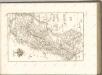


Generální mapa Protektorátu Čechy a Morava

Trenčín
1 : 75000 Slovensko Vojenský zeměpisný ústav
Die Markgrafschaft Maehren mit dem Herzogthume Schlesien

Markgrafschaft Mähren und Herzogthum Schlesien
Malá Fatra

C. Thurotziensis
Slowakei Komitat Martin (Slowakei)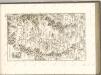
Komunikační mapa země Moravskoslezské
1 : 100000 Vsetín (Česko : oblast) Morslez. zem. výbor

Turistické cesty na Valašsku
Politické okresy valašskomeziříčský a vsetínský
1 : 200000 Valašské Meziříčí-oblast (Česko) Plesinger, Václav V. Plesinger
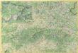
Sillein und Wagg-Bistritz.
from Spezialkarte der osterreichisch-ungarischen Monarchie.
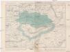
Mappa comitatvs Thvrotziensis
1 : 165000 Turanská nížina Mikoviny, Sámuel Nicolai, Georg David Christoph
Mappa Comitatvs Thvrotziensis.
1 : 160000 Mollova mapová sbírka Mikoviny, Sámuel
Viszoka-Mako und Kisuca-Ujhely.
from Spezialkarte der osterreichisch-ungarischen Monarchie.
Velká Fatra

Malá Fatra

Mosocz und Altgebirg (Ohegy).
from Spezialkarte der osterreichisch-ungarischen Monarchie.
Horné Ponitrie

Ružomberok
1 : 75000 Ružomberok (Slovensko : oblast) Vojenský zeměpisný ústav
Ružomberok
1 : 75000 Ružomberok-oblast (Slovensko) Vojenský zeměpisný ústav
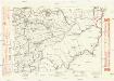
Ružomberok a Turčiansky Sv. Martin
1 : 75000 Martin (Slovensko : oblast) Vojenský zeměpisný ústav


