Maps of Trenčínský
Střední Pováží

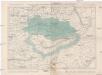
Trencsén vármegye térképe
1 : 355000 Trenčín (Slovensko : oblast) Kogutowicz, Manó Magyar Földrajzi Intézet
C. Trencsin
Slowakei Komitat Trentschin
Stolice Trenčín. Stolice Turec
Trenčín (Okres), Komitat Martin (Slowakei), ethnische Gruppe
Mapa země moravské

Mapa země Moravské. S částmi pohraničnými Slezska, Čech, Rakous i Uher

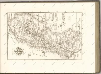
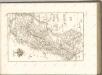
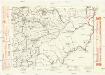
Comitat Trencsin
1 : 288000 Trenčín-oblast (Slovensko)
Comitat Trencsin
1 : 280000 Trenčín-oblast (Slovensko)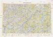
Neubertova generální automapa Republiky československé
1 : 200000 Banská Bystrica (Slovensko : oblast) Soukup, Jan V. Neubert a synové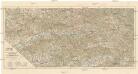
Střední Pováží
1 : 200000 Pováží (Slovensko) odbor Klubu českoslov. turistů
Trentschin 120, uit: Special-Karte von Mittel-Europa / nach amtlichen Quellen bearbeitet von W. Liebenow
1 : 300000 titelvariant: W. Liebenow's Mittel-Europa; Annotatie: Titel boven de bladen: W. Liebenow's Mittel-Europa Johannes Wilhelm Liebenow 1822-1897 Frankfurt a. M. : Ludwig Ravenstein
Die Markgrafschaft Maehren mit dem Herzogthume Schlesien

Markgrafschaft Mähren und Herzogthum Schlesien

Trenčín
1 : 75000 Slovensko Vojenský zeměpisný ústav
Generální mapa Protektorátu Čechy a Morava

Komunikační mapa země Moravskoslezské
1 : 100000 Vsetín (Česko : oblast) Morslez. zem. výbor
Turistické cesty na Valašsku
Politické okresy valašskomeziříčský a vsetínský
1 : 200000 Valašské Meziříčí-oblast (Česko) Plesinger, Václav V. Plesinger
Malá Fatra

Carte Topographique d'Allemagne.
1 : 220000 Mollova mapová sbírka Jaeger, Johann Wilhelm Abraham Berndt, Johann Christoph Jäger, Johann Wilhelm Abraham
Těšínsko

Moravskoslezské Bezkydy
1 : 100000 Javorníky (Česko a Slovensko) Karl, F. Pták, J. nákladem Pobezkydské župy
Beskydy

Beskydy

Beskydy
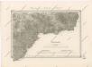
II. vojenské mapování 11
1 : 144000
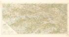
II. vojenské mapování 11
1 : 144000