Maps of District of Žilina


Těšínsko

Trentschin 120, uit: Special-Karte von Mittel-Europa / nach amtlichen Quellen bearbeitet von W. Liebenow
1 : 300000 titelvariant: W. Liebenow's Mittel-Europa; Annotatie: Titel boven de bladen: W. Liebenow's Mittel-Europa Johannes Wilhelm Liebenow 1822-1897 Frankfurt a. M. : Ludwig Ravenstein
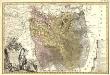
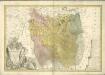
Comitat Trencsin
1 : 288000 Trenčín-oblast (Slovensko)
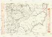
Comitat Trencsin
1 : 280000 Trenčín-oblast (Slovensko)
Stolice Trenčín. Stolice Turec
Trenčín (Okres), Komitat Martin (Slowakei), ethnische Gruppe
Malá Fatra
Principatvs Sielasiae Teschinensis nova et accurata
1 : 116000 Mollova mapová sbírka Wieland, Johann Wolfgang Homann, Johann Baptista - dědici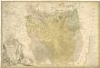
Teschinensis

C. Trencsin
Slowakei Komitat Trentschin
Teschner Kreis

Der Teschner Kreis
1 : 200000 Český Těšín-oblast (Česko) Schenkl, Conrad Philipp Winiker, Karel Carl Winiker
Das Fürstenthum Teschen in Ober-Schlesien
1 : 1170000 Těšínské Slezsko Schleuen, Johann David Schleuen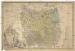
Principatvs Silesiae Teschinensis nova et accurata delineatio
1 : 130000 Těšínské Slezsko Wieland, Johann Wolfgang ab Homannianis Heredibus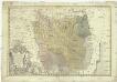
Principatvs Silesiae Teschinensis nova et accurata delineatio distincte insimul exhibens
1 : 125000 Těšínské Slezsko Wieland, Johann Wolfgang Homannianos Heredes
Beskydy

Beskydy
II. vojenské mapování 11
1 : 144000
Der Teschner Kreis
1 : 200000 Český Těšín-oblast (Česko) Schenkl, Conrad Philipp Carl Winiker
[Die Markgraftschaft Mähren]
1 : 200000 Český Těšín-oblast (Česko) Schenkl, Conrad Philipp Carl Winiker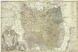
Principatvs Silesiae Teschinensis
1 : 115000 Těšínské Slezsko Homannianis Heredibus
Sbírka map a diagramů použitých na mírových konferencích v Paříži v letech 1919 - 1920
Komunikační mapa země Moravskoslezské
1 : 100000 Vsetín (Česko : oblast) Morslez. zem. výbor
Nova et accurata geographica delineatio Ducatus Teschenensis...

Nova et accurata geographica delineatio Ducatus Teschenensis...

Sbírka map a diagramů použitých na mírových konferencích v Paříži v letech 1919 - 1920

Generální mapa Protektorátu Čechy a Morava

157. Pless, uit: Topographische Uebersichtskarte des Deutschen Reiches / herausgegeben v. d. Kartogr. Abt. d. Königl. Preuß. Landesaufnahme
1 : 200000 titelvariant: Topogr. Übersichtskarte des Deutschen Reiches; Annotatie: Titel boven bladen ook: Topogr. Übersichtskarte des Deutschen Reiches; Annotatie geografische gegevens: Op elk blad twee maatstokken: 10 Kilometer = 5,5 cm; 1 geogr. Meile = 3,6 cm; Legenda onder op elk blad Königlich Preußische Landesaufnahme. Kartographische Abtheilung [S.l : Königlich Preußische Landesaufnahme, Kartographische Abtheilung]