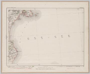
Maps of Simrishamns kommun

Simrishamn 5, uit: Special-Karte von Mittel-Europa / nach amtlichen Quellen bearbeitet von W. Liebenow
1 : 300000 titelvariant: W. Liebenow's Mittel-Europa; Annotatie: Titel boven de bladen: W. Liebenow's Mittel-Europa Johannes Wilhelm Liebenow 1822-1897 Frankfurt a. M. : Ludwig Ravenstein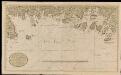
Nieuwe affteekening vande kust van Blekingen vertoonende Carelshaven en Carelskroon int groot
Sweden Gerard van Keulen

[68][68] Accurata Scaniae, Blekingiae et Hallandiae descriptio, uit: Atlas sive Descriptio terrarum orbis
Annotatie: Gedigitaliseerde versie. Amsterdam. Heiloo : Picturae (vervaardiger), 2015. tiff-bestand. Gedigitaliseerd: 07-01-2015; Origineel: Universiteitsbibliotheek Vrije Universiteit (XL.05127.-) ; Netherlands; Titelpagina ontbreekt Wit, Frederik de Amsterdam : Frederick de Wit

Nova tabula Scaniae, quae est Gothia australis provincias Scaniam, Hallandiam, et Blekingiam complectens
1 : 560000 Švédsko jižní Homann, Johann Baptist J.B. Homann
Nova tabula Scaniae / accurate exhibita â Ioh. Bapt. Homanno
1 : 480000 1 Karte : Kupferdruck ; 46 x 55 cm Homann, Johann Baptist [Johann Baptist Homann]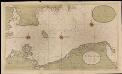
Een gedeelte van de Oost Zee streckende van de Sondt tot aen Dantzigk
Germany Gerard van Keulen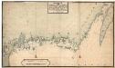
Museumskart 153: Blekings landt og Söeküst fra Christianstad Hen op giennem Calmer sund
1 : 50000 Jens Sørensen
Sect. 3: Rügenwalde, uit: Geologische Karte des Deutschen Reichs in 27 Blaettern / [von] Richard Lepsius ; Red. von C. Vogel
1 : 500000 Annotatie: Blad 18 ontbreekt; Een aantal bladen op linnen; Een aantal bladen gereviseerd 1913-1914; Annotatie geografische gegevens: Met schaalstokken o.a. in kilometers; Legenda Carl Vogel 1828-1897 Gotha : Justus Perthes
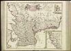
SCANIA | Vulgo | SCHOONEN.
[Amsterdam : Joan Blaeu]
Nova et accurata Scaniae et maximae partis Zeelandiae tabula
1 : 325000 A Amsterdam : chez Jean Cóvens et Corneille Mortier
Scania, Vulgo Schonen. [Karte], in: Novus atlas absolutissimus, Bd. 1, S. 122.
1 Karte aus Atlas Janssonius Offizin
In Bornholm 14, uit: Special-Karte von Mittel-Europa / nach amtlichen Quellen bearbeitet von W. Liebenow
1 : 300000 titelvariant: W. Liebenow's Mittel-Europa; Annotatie: Titel boven de bladen: W. Liebenow's Mittel-Europa Johannes Wilhelm Liebenow 1822-1897 Frankfurt a. M. : Ludwig Ravenstein
Operationum bellicarum in Germania ulterior Repraesentatio
1 : 700000 Mollova mapová sbírka Rizzi Zannoni, Giovanni Antonio Homann, Johann Baptista - dědici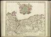
[41][41] Ducatus Pomeraniae tabula generalis, ..., uit: Atlas sive Descriptio terrarum orbis
Annotatie: Gedigitaliseerde versie. Amsterdam. Heiloo : Picturae (vervaardiger), 2015. tiff-bestand. Gedigitaliseerd: 07-01-2015; Origineel: Universiteitsbibliotheek Vrije Universiteit (XL.05127.-) ; Netherlands; Titelpagina ontbreekt Wit, Frederik de Amsterdam : Frederick de Wit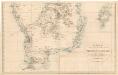
Trigonometrisk grunnlag, vedlegg 64a: Ort-Bestämmelsen i Södra Delen af Swerige
1 : 500000
Carte du royaume de Danemarck
1 : 1190000 Dánsko Delisle, Guillaume Buache, Philippe Ph. Buache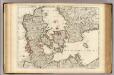
Danemarc.
1 : 965000 L'Isle, Guillaume de, 1675-1726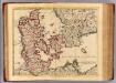
Danemarc.
1 : 970000 L'Isle, Guillaume de, 1675-1726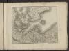
Théatre de la guerre actuelle, en Allemagne, en Pologne et en Turquie. n3 (bis)
1 : 900000 Chanlaire, Pierre Grégoire 1758-1817 Paris : chez l'auteur P. G. Chanlaire
Pomerania XIIII. Nova Tabula. [Karte], in: Claud. Ptolemaeus. Geographia lat. cum mappis [...], S. 392.
1 Karte aus Atlas Münster, Sebastian [und Ptolemaeus, Claudius]

Homannův atlas světa
1 : 930000
Regnum Daniae, divisum in Dioeceses Arhusiam, Albergum, Viborgum et Ripam, Insulas Zelandiam, Fioniam, Lalandiam, Falstriam, Monam, Langelandiam, Arram, Samsoam, Amagam, Soltholmiam et Bornholmiam, et partem in Ducatibus Slesvico et Holsatia
1 : 750000 per Gerardo et Leonardo Valk [Amsterdam], Gerardo et Leonardo Valk
Carte du royaume de Danemarc
1 : 1000000 Dánsko Delisle, Guillaume Iean Covens et Corneille Mortier
DANIAE cum Serie Insularum suarum Regn
Dánsko