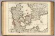
Maps of Denmark

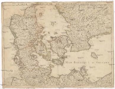
Carte du royaume de Danemarck
1 : 1190000 Dánsko Delisle, Guillaume Buache, Philippe Ph. Buache
Homannův atlas světa
1 : 930000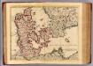
Danemarc.
1 : 970000 L'Isle, Guillaume de, 1675-1726
Carte du royaume de Danemarc
1 : 1000000 Dánsko Delisle, Guillaume Iean Covens et Corneille Mortier

Karte von dem Koenigreiche Daenemark
1 : 1000000 Dánsko Reilly, Franz Johann Josef von Franz Ioh. Ios. von Reilly
Dania regnvm
Dánsko
[DANIA REGNUM in quo sunt ducatus HOLSATIA et SLESVICUM INSULAE DANICAE et PROVINCIAE IUTIA, SCANIA, BLEKINGIA ET HALLANDIA]
1 : 1050000 Dánsko Wit, Frederick de F. de Wit
Danemarc.
1 : 965000 L'Isle, Guillaume de, 1675-1726
Charte des Königreichs Daenemark, nach Murdochischer Projection und nach den trigonometrischen Charten der König
1 : 919000
Königreich Daenemark
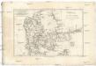
1 : 2530000 Dánsko
Regni Daniae in quo sunt ducatus Holsatia et Slesvicum insulae Danicae provinciae Iutia Scania Blekingia nova tabula
1 : 1100000 Dánsko Homann, Johann Baptist
Regni Daniae, in quo sunt ducatus Holsatia et Slesvicum, insulae Danicae, provinciae Iutia Scania Blekingia etc. nova tabula
1 : 1100000 Dánsko Homann, Johann Baptist â Io. Baptista Homanno
Regni Daniae, in quo sunt ducatus Holsatia et Slesvicum, insulae Danicae, provinciae Iutia Scania Blekingia etc. nova tabula
1 : 1100000 Dánsko Homann, Johann Baptist â Io. Baptista Homanno
REGNI DANIAE, in quo sunt DUCATUS HOLSATIA ET SLESVICUM, INSULAE DANICAE, PROVINCIA IUTIA SCANIA BLEKINGIA &c. Nova Tabula
1 : 1100000 Dánsko Homann, Johann Baptist a Io. Baptista Homanno
Regni Daniae
1 : 1129000 Dánsko Visscher, Nicolaus per Nicolaum Visscher
REGNI DANIAE, Novißima et accuratißima TABULA
1 : 1130000 Dánsko Visscher, Nicolaus per Nicolaum Visscher
Das Königreich Daenemark
1 : 1090000 Dánsko Weiland, Karl Ferdinand Geographischen Institut
Das Königreich Daenemark
1 : 1090000 Dánsko Weiland, Karl Ferdinand Maedel, A. Geograph. Institut
Daniae Regnum [Karte], in: Atlas, sive, Cosmographicae meditationes de fabrica mundi et fabricati figura, S. 135.
1 Karte aus Atlas Mercator, Gerhard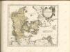


Regni Daniae accuratissima delineatio
1 : 1150000 Dánsko Wit, Frederick de Frederick de Witt
DANIA | REGNVM.
[Amsterdam : Joan Blaeu]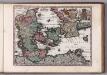
Daniae Reg. cum Ducatu Holsatiae et Slesvici
1 : 500000 Weyerman, Jacob Campo
Daniae Regnum [Karte], in: Gerardi Mercatoris et I. Hondii Newer Atlas, oder, Grosses Weltbuch, Bd. 1, S. 103.
1 Karte aus Atlas Mercator, Gerhard und Hondius, Jodocus Jansson, Jan
Das Königreich Daenemark
1 : 1090000 Dánsko Weiland, Karl Ferdinand Geographisches Institut
Dania regnum in quo sunt ducatus Holsatia et Slesvicum insulae Danicae et provinciae Iutia Scania Blekingia et Hallandia
1 : 1100000 Dánsko Danckerts, Justus per I. Danckers