Maps of Skåne län

[68][68] Accurata Scaniae, Blekingiae et Hallandiae descriptio, uit: Atlas sive Descriptio terrarum orbis
Annotatie: Gedigitaliseerde versie. Amsterdam. Heiloo : Picturae (vervaardiger), 2015. tiff-bestand. Gedigitaliseerd: 07-01-2015; Origineel: Universiteitsbibliotheek Vrije Universiteit (XL.05127.-) ; Netherlands; Titelpagina ontbreekt Wit, Frederik de Amsterdam : Frederick de Wit


Nova tabula Scaniae, quae est Gothia australis provincias Scaniam, Hallandiam, et Blekingiam complectens
1 : 560000 Švédsko jižní Homann, Johann Baptist J.B. Homann
Nova tabula Scaniae / accurate exhibita â Ioh. Bapt. Homanno
1 : 480000 1 Karte : Kupferdruck ; 46 x 55 cm Homann, Johann Baptist [Johann Baptist Homann]
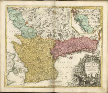
SCANIA | Vulgo | SCHOONEN.
[Amsterdam : Joan Blaeu]
Scania, Vulgo Schonen. [Karte], in: Novus atlas absolutissimus, Bd. 1, S. 122.
1 Karte aus Atlas Janssonius Offizin
Nova et accurata Scaniae et maximae partis Zeelandiae tabula
1 : 325000 A Amsterdam : chez Jean Cóvens et Corneille Mortier
Museumskart 153: Blekings landt og Söeküst fra Christianstad Hen op giennem Calmer sund
1 : 50000 Jens Sørensen
Simrishamn 5, uit: Special-Karte von Mittel-Europa / nach amtlichen Quellen bearbeitet von W. Liebenow
1 : 300000 titelvariant: W. Liebenow's Mittel-Europa; Annotatie: Titel boven de bladen: W. Liebenow's Mittel-Europa Johannes Wilhelm Liebenow 1822-1897 Frankfurt a. M. : Ludwig Ravenstein
Kjöbenhavn 4, uit: Special-Karte von Mittel-Europa / nach amtlichen Quellen bearbeitet von W. Liebenow
1 : 300000 titelvariant: W. Liebenow's Mittel-Europa; Annotatie: Titel boven de bladen: W. Liebenow's Mittel-Europa Johannes Wilhelm Liebenow 1822-1897 Frankfurt a. M. : Ludwig Ravenstein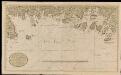
Nieuwe affteekening vande kust van Blekingen vertoonende Carelshaven en Carelskroon int groot
Sweden Gerard van Keulen
Strait Denmark-Sweden.
1 : 150000 Nordenankar, J.
Ostsee
1 : 100000 Baltské moře Reichs-Marine-Amt
Kjöbenhavn : med nærmeste omegn 1903
1 : 10000 Kjøbenhavns Kommunes Foranstaltning Kjøbenhavns Kommunes Ejendomme
Copenhagen = (Kiöbenhaven)
1 : 12500 Clarke, W. B published by the Superintendence of the Society for the Diffusion of Useful Knowledge [by] George Cox
Kopenhagen
1 : 27700 Kodaň (Dánsko) F.A. Brockhaus' geogr.-artist. Anstalt
Copenhagen
Grosser Hand-Atlas über alle Theile der Erde in 170 Karten Meyer, J. Verlag des Bibliographischen Instituts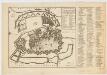
Naaukeurige aftekening van de koninglyke Deensche hoofd en residentie stad Koppenhagen : met de aftekening van de swaren brand op den 20 October en volgende dagen A° 1728
Ottens, R. (Reinier), 1698-1750 Reinier & Josua Ottens
Copenhagen

Kopenhagen
1 : 21500 Kodaň (Dánsko) Bibliographisches Institut
Plan af Kjöbenhavn med Forstaeder
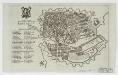
Grund tegning af den kongelige reisdenz stad Kiøbenhavn
Fridrich, Johann Gottlieb, 1742-1809
COPPENHAGEN die königl. Dänische Haupt und Residentz Stadt
Kodaň (Dánsko) Seutter, Matthäus Kraus, Johann Thomas von Matth. Seutter
Coppenhagen die königl. dänische Haupt und Residentz Stadt
Kodaň (Dánsko) Kraus, Johann Thomas Seutter, Matthäus Matth. Seutter
INSULA HVÆNA, | sive | VENUSIA, | à GVILJELMO BLAEV, | cum sub TYCHONE Astronomiæ | operam daret, delineata.
[Amsterdam : Joan Blaeu]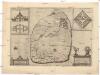
Topographia insulae Huenae in celebri porthmo regni Daniae, quem vulgo Oersunt uocant

Plan af Kjöbenhavn = Plan of Copenhagen
1 : 8857 Em. Baerentzen & Co Em. Baerentzen & Co.