Maps of Slovenia

Blatt VI, uit: Geologische Übersichts-Karte der Österreichisch-Ungarischen Monarchie / nach den Aufnahmen der K.K. Geologischen Reichsanstalt bearb. von Franz Ritter von Hauer ; gezeichn. von Eduard Jahn
1 : 576000 Annotatie geografische gegevens: Gebaseerd op veldwerk in de jaren 1850 tot 1865 Hauer, Franz Ritter von; Jahn, Eduard; Kaiserlich-Königliche Geologische Reichsanstalt, Wenen Wien : Beck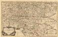
Partie du Cercle d'Austriche, ou sont Les Duchés de Stirie, de Carinthie, de Carniole
1 : 650000 Mollova mapová sbírka Sanson, Guillaume Jaillot, Alexis Hubert
Wnitro-rakauské země
Chorvatsko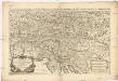
Partie du cercle d'Austriche, ou sont les duchés de Stirie, de Carinthie, de Carniole et autres estats heriditaires a la maison d'Austriche
1 : 630000 Korutansko (Rakousko) Sanson, Guillaume Jaillot, Alexis-Hubert H. Iaillot
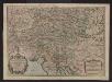
Partie du cercle d'Austriche ou sont les duchés de Stirie, de Carinthie, de Carniole et autres estats hereditaires a la maison d'Austriche
Kärnten, Steiermark Sanson, Guillaume ; Jaillot, Alexis Hubert
Charte von Innerostreich od. den Herzogthumern Steyermark, Kaernten u. Krain, mit den Gebiethen v. Gorz u. Triest
1 : 650000 Chorvatsko Streit, Friedrich Wilhelm Liechtenstern, Joseph Marx von
Karnthen, Krain, Gorz-Gradisca, Istrien, Triest.
1 : 875000 Flemming, Carl
Hertzogthumber Steyer, Karnten, Krain &c.
1 : 880000 Mollova mapová sbírka Sanson, Nicolas Sanson, Nicolas
Circuli Austriaci in quo sunt archiducatus Austriae ducatus Stiriae Carintiae Carniolae comitatus Tirolis et episcopatus Tridentini novissima descriptio
1 : 920000 Evropa střední Danckerts, Justus per Iustinum Danckerts
Carte internationale du monde au 1,000,000 E
1 : 1000000 Terst (Itálie) Istituto geografico militare
Süd-östliches Deutschland
1 : 1850000 Evropa jihovýchodní Stieler, Adolf
Circvli Avstriaci Pars posterior et principalis complectens Archid. Austriae Ducatus Styriae Carinthiae et Carniolae
1 : 2600000 Mollova mapová sbírka Franz, Johann Michael Homann, Johann Baptista - dědici
Vetvs Avstria Cisdanvbiana Norica
1 : 2160000 Mollova mapová sbírka Clüver, Philipp Fuhrmann, Mathias
Die Herzogthümer Steiermark, Kärnten, Krain
1 : 600000 Brionské ostrovy (Chorvatsko) Gräf, Carl Geyer, Valentin Geographisches Institut
Die Herzogthümer Steiermark, Kärnten, Krain, die gefürstete Grafschaft Görz und Gradiska, die Markgrafschaft Istrien, die Stadt Triest mit Gebiet und das ungarische Litorale
1 : 550000 Brionské ostrovy (Chorvatsko) Gräf, C. Geyer, V. Geographisches Institut

Das Königreiche Illyrien und das Herzogthum Steyermark
1 : 700000 Ilýrie Weiland, Karl Ferdinand Anson im Verlage des geographischen Instituts
Das Königreiche Illyrien und das Herzogthum Steyermark
1 : 700000 Ilýrie Weiland, Karl Ferdinand Anson im Verlage des geographischen Instituts
Charte von dem Königreiche Illyrien und dem Herzogthume Steyermark
1 : 690000 Ilýrie Weiland, Karl Ferdinand Bürck, A. im Verlage des Geograph. Instituts
Charte von dem Königreiche Illyrien und dem Herzogthume Steyermark
1 : 690700 Ilýrie Weiland, Karl Ferdinand Bürek, A. im Verlage des Geograph. Instituts
Die Provinz Inner-OEsterreich oder die Herzogthümer Steyermark, Kaernten und Krain, die Grafschaften Goerz und Gradisca und das deutsch-oesterreichische Litorale
1 : 740000 Gorice a Gradiška Kindermann, Joseph Karl Junker, Christoph Franz Xaver Miller
Pannonia svperior svb Romanis ab Avgvsto ad finem saecvli IIII
Panonie Gruber, P. Leop. Grimm, M.
Carte du royaume d'Illirie et du duché de Styrie
1 : 520000 Ilýrie Raffelsperger, Franz Rumpold, F. au Dépôt des cartes typografiées
Karte von Inner-Österreich, das ist des Königreiches Illirien und des Herzogthumes Steiermark
1 : 880000 Ilýrie Raffelsperger, Franz Rumpold, F. im Typographischen Landkarten-Verlage
Slovinci ve Štýrsku, v Korutanech, v Kraňsku a v Přímoří
Jaderské moře (oblast) Brož, Josef Československá společnost zeměvědná
Vindové
Chorvatsko Müller, Jos. D. Jungmann, C.
Circuli Austriaci in quo Sunt Archiducatus Austriae Ducatus Stiriae Carintiae Carniolae et Episcopatus Tridentini Novissima Descriptio
1 : 900000 Mollova mapová sbírka Danckerts, Justus Danckerts, Justus
Geologische karte der Republik Österreich und der Nachbargebiete: Die Ostalpen, ihre Ausläufer und Vorlande nebst den angrenzenden Teilen der fränkisch-schwäbischen Alb und des böhmischen Massivs
Vetters, Hermann.


