Maps of Slovenia

Carte internationale du monde au 1,000,000 E
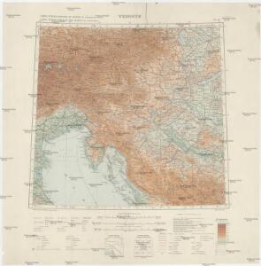
1 : 1000000 Terst (Itálie) Istituto geografico militare
Königreich Illyrien nach der neuesten Eintheilung
1 : 1250000 Balkánský poloostrov
Königreich Illyrien nach der neuesten Eintheilung
1 : 1250000 Balkánský poloostrov
Charte von Innerostreich od. den Herzogthumern Steyermark, Kaernten u. Krain, mit den Gebiethen v. Gorz u. Triest
1 : 650000 Chorvatsko Streit, Friedrich Wilhelm Liechtenstern, Joseph Marx von
Partie Du Cercle D'Austriche, Ou Sont Les Duchés De Stirie, De Carinthie, De Carniole, et autres Estats Hereditaires al la Maison d'Austriche. [Karte], in: Atlas nouveau, contenant toutes les parties du monde [...], Bd. 1, S. 254.
1 Karte aus Atlas Sanson, Nicolas Jaillot, Alexis Hubert und Mortier, Pieter
Karte von Innerösterreich
1 : 800000 Bosanska Krajina (Bosna a Hercegovina) Mollo, Tranquillo bey Tranquillo Mollo
Regni Norici et Pannoniae Superioris Veteres Populi et Inquilini
1 : 2850000 Mollova mapová sbírka Clüver, Philipp Fuhrmann, Mathias
Partie du cercle d'Austriche ou sont les duchés de Stirie, de Carinthie, de Carniole et autres estats hereditaires a la maison d'Austriche
Kärnten, Steiermark Sanson, Guillaume ; Jaillot, Alexis Hubert
Königreich Illyrien
1 : 1250000 Evropa jihovýchodní Mollo, Tranquillo Tranquillo Mollo
Karte von Inneroesterreich oder das Herzoghtum Steyermark, Kaernthen und Krain
1 : 1080000 Korutansko (Rakousko) T. Mollo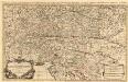
Partie du Cercle d'Austriche, ou sont Les Duchés de Stirie, de Carinthie, de Carniole
1 : 650000 Mollova mapová sbírka Sanson, Guillaume Jaillot, Alexis Hubert
Königreich Illyrien
1 : 1233000 Ilýrie

Hertzogthumber Steyer, Karnten, Krain &c.
1 : 880000 Mollova mapová sbírka Sanson, Nicolas Sanson, Nicolas
Sclavonia oder Windisch Marck, Bossen, Crabaten, etc. ; Sclauonia oder Windisch Marck, Bossen, Crabaten, ec.
1 : 330000 Krain, Steiermark Münster, Sebastian
Süd-östliches Deutschland
1 : 1850000 Evropa jihovýchodní Stieler, Adolf
Karnthen, Krain, Gorz-Gradisca, Istrien, Triest.
1 : 875000 Flemming, Carl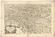
Partie du cercle d'Austriche, ou sont les duchés de Stirie, de Carinthie, de Carniole et autres estats heriditaires a la maison d'Austriche
1 : 630000 Korutansko (Rakousko) Sanson, Guillaume Jaillot, Alexis-Hubert H. Iaillot
Haupt Kart Austria
Rakousko
Karte der Kroländer Steyermark, Kärnthen, Krain und Istrien
1 : 1530000 Istrijský poloostrov (Slovinsko a Chorvatsko) Marco Berra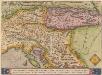
Schlavoniae, Croatie, Carniae, Istriae, Bosniae, Finitimarumque Regionum Nova Descriptio [Karte], in: Theatrum orbis terrarum, S. 258.
1 Karte aus Atlas Ortelius, Abraham
Li Dvcati di Stiria Carintia é Carniola
Mollova mapová sbírka Cantelli, Giacomo Donia, Francesco De Rossi, Giovanni Giacomo
Carte du royaume d'Illirie et du duché de Styrie
1 : 520000 Ilýrie Raffelsperger, Franz Rumpold, F. au Dépôt des cartes typografiées
Karte von Inner-Österreich, das ist des Königreiches Illirien und des Herzogthumes Steiermark
1 : 880000 Ilýrie Raffelsperger, Franz Rumpold, F. im Typographischen Landkarten-Verlage

Das Königreich Illyrien und das Herzogthum Steyermark
1 : 700000 Ilýrie Weiland, Karl Ferdinand im Verlage des geographischen Instituts
Illyricum. [Karte], in: Theatrum orbis terrarum, S. 350.
1 Karte aus Atlas Ortelius, Abraham Vrients, Jan Baptista
Oesterr. Kronlander.
1 : 700000 Weiland, C. F. (Carl Ferdinand), d. 1847
Schlavoniae, Croatiae, Carniae, Istriae, Bosniae, Finitimarumque Regionum Nova Descriptio
Südosteuropa Hirschvogel, Augustin