Maps of Slovenia
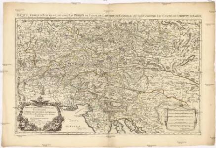
Partie du cercle d'Austriche, ou sont les duchés de Stirie, de Carinthie, de Carniole et autres estats heriditaires a la maison d'Austriche
1 : 630000 Korutansko (Rakousko) Sanson, Guillaume Jaillot, Alexis-Hubert H. Iaillot
Partie du Cercle d'Austriche, ou sont Les Duchés de Stirie, de Carinthie, de Carniole
1 : 650000 Mollova mapová sbírka Sanson, Guillaume Jaillot, Alexis Hubert
Partie du cercle d'Austriche ou sont les duchés de Stirie, de Carinthie, de Carniole et autres estats hereditaires a la maison d'Austriche
Kärnten, Steiermark Sanson, Guillaume ; Jaillot, Alexis Hubert
Partie Du Cercle D'Austriche, Ou Sont Les Duchés De Stirie, De Carinthie, De Carniole, et autres Estats Hereditaires al la Maison d'Austriche. [Karte], in: Atlas nouveau, contenant toutes les parties du monde [...], Bd. 1, S. 254.
1 Karte aus Atlas Sanson, Nicolas Jaillot, Alexis Hubert und Mortier, Pieter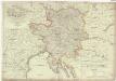
Karte von Innerösterreich
1 : 800000 Bosanska Krajina (Bosna a Hercegovina) Mollo, Tranquillo bey Tranquillo Mollo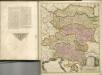

Haupt Kart Austria
Rakousko
Austria.
1 : 2700000 Bowen, Frances
Karte von Inneroesterreich oder das Herzoghtum Steyermark, Kaernthen und Krain
1 : 1080000 Korutansko (Rakousko) T. Mollo
Hertzogthumber Steyer, Karnten, Krain &c.
1 : 880000 Mollova mapová sbírka Sanson, Nicolas Sanson, Nicolas
Carte internationale du monde au 1,000,000 E
1 : 1000000 Terst (Itálie) Istituto geografico militare
Postkarte von dem oesterreichischen Kreise
Rakousko (1526-1804) Müller, Franz im von Reilly'schen Landkarten und Kunstwerke Verschleiss Komptoir
Postkarte von dem oesterreichischen Kreise
Rakousko (1526-1804) Müller, Franz Reilly'schen Landkarten und Kunstwerke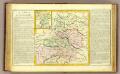
Cercle d'Autriche.
1 : 1450000 Clouet, J. B. L. (Jean-Baptiste Louis), b. 1730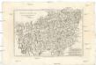
Cercle d'Autriche
1 : 1740000 Rakousko Bonne, Rigobert André
Blatt VI, uit: Geologische Übersichts-Karte der Österreichisch-Ungarischen Monarchie / nach den Aufnahmen der K.K. Geologischen Reichsanstalt bearb. von Franz Ritter von Hauer ; gezeichn. von Eduard Jahn
1 : 576000 Annotatie geografische gegevens: Gebaseerd op veldwerk in de jaren 1850 tot 1865 Hauer, Franz Ritter von; Jahn, Eduard; Kaiserlich-Königliche Geologische Reichsanstalt, Wenen Wien : Beck
Übersichts Karte von Inner Österreich
1 : 575000 Korutansko (Rakousko) Schwab, G.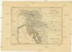
Königreich Illyrien nach der neuesten Eintheilung
1 : 1250000 Balkánský poloostrov
Königreich Illyrien nach der neuesten Eintheilung
1 : 1250000 Balkánský poloostrov
Circuli Austriaci in quo sunt archiducatus Austriae ducatus Stiriae Carintiae Carniolae comitatus Tirolis et episcopatus Tridentini novissima descriptio
1 : 920000 Evropa střední Danckerts, Justus per Iustinum Danckerts
Charte von Innerostreich od. den Herzogthumern Steyermark, Kaernten u. Krain, mit den Gebiethen v. Gorz u. Triest
1 : 650000 Chorvatsko Streit, Friedrich Wilhelm Liechtenstern, Joseph Marx von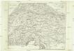
Post-Karte zur Geschichte des Kriegs von 1809
Itálie
Carte itinéraire pour servir a l'histoire de la guerre de 1809
Evropa střední
St. Lucia und die Luzien-Percht am Südostrande der Alpen
Österreich, Slowenien, Volkskunde Umschaden, Kurt ; Neunteufl, Walter
Der oesterreichische Kreis ohne die Vorlande
1 Karte : Kupferdruck ; 50 x 63 cm Mannert in der kais. priv. Kunsthandlung Adam Gottl: Schneider u: Weigel
Süd-östliches Deutschland
1 : 1850000 Evropa jihovýchodní Stieler, Adolf
Vetvs Avstria Cisdanvbiana Norica
1 : 2160000 Mollova mapová sbírka Clüver, Philipp Fuhrmann, Mathias
Die Provinz Inner-OEsterreich oder die Herzogthümer Steyermark, Kaernten und Krain, die Grafschaften Goerz und Gradisca und das deutsch-oesterreichische Litorale
1 : 740000 Gorice a Gradiška Kindermann, Joseph Karl Junker, Christoph Franz Xaver Miller
Leopoldi Magni Filio Iosepho I. Avgvsto Romanorvm et Hvng: Regi Ad capeßendum Rhenanae Militia Imperium in Castra proficiscenti Hanc Germaniae Avstriacae Generalem Tabvlam
1 : 1430000 Mollova mapová sbírka Homann, Johann Baptist Homann, Johann Baptista