Maps of Israel

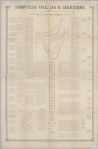
Synoptische tafel der H. Geschiedenis : van Mozes tot aan den tempel van Salomon (1491-1005 vóór Christus) / door H. Lambrecht
Annotatie: Hierop afgebeeld: Kaart voor de geschiedenis der reis van de Joden uit Egypte naar het land van belofte en hunner intrede in dat land. - Schaal: [1:3.000.000]. Palestina tusschen de 12 stammen verdeeld. - Schaal: [1:1.875.000] [S.l. : s.n.] / (Gent : Poelman)
Historische Karte von Palestinae und Arabia Petraea mit einen grossen Theil von AEgypten
1 : 1100000 Egypt Mayr, Georg Wilkendorf, Fr. Mey & Widmayer
Palestine.
1 : 1027000 Colton, G. Woolworth
Biblische-Karte
Jeruzalém Růžička, Jan Hichmann, A.
Afbeelding van Egypte, de woestyne der Schelfzee, en 't Land Kanaan : strekkende tot opheldering der bybelsche geschiedenis, dewelke begint van Jakobs vertrek naar Egypte, en eindigt met de verwinning van 't Land Kanaan
1 : 1400000 ontworpen door W.A. Bachiene J. van Jagen mapp. sculpsit, et figur. apposit. sculpturam curavit ; J.C. Philips fecit. te Gorinchem : by Nicolaas Goetzee
Terra Promissionis
Sinajský poloostrov (Egypt) Dalrymple, Alexander Berra, Marco
Palestine - Physical Geography.
Milner, Thomas
TERRA SANCTA | quae in Sacris | Terra Promissionis olim | PALESTINA
Amstelodami | Ex officina Guiljelmi Blaeuw 1629
Palestine, l'Arabie Petree.
1 : 1370000 Andriveau-Goujon, J.
Terra Sancta quae in Sacris Terra Promissionis olim Palestina [Karte], in: Le théâtre du monde, ou, Nouvel atlas contenant les chartes et descriptions de tous les païs de la terre, Bd. 2, S. 276.
1 Karte aus Atlas Blaeu, Willem Janszoon und Blaeu, Joan Blaeu, Willem Janszoon
Polostrov [sic] Sinajský s naznačeným pochodem Israelitův přes poušť k vydobytí země Kanaan
1 : 1900000 Izrael Uměl. závod Ed. Hölzela
Canaan.
Lavoisne, M.
Tabula itineris, et stationum Israelitarum in deserto
1 : 950000 Palestina Starckman, P.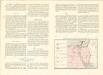
Historický atlas revolučního hnutí

Mansionum populi Israelitici in deserto.
Sinajský poloostrov (Egypt) Grasmüller, E. Demeuse, Laurent
Terre de Chanaan ou Terre Promise.
1 : 3200000 Houze, Antoine Philippe
Kaart van de veertigjarige omzwerving der Israëliten in de woestijn van Arabië
1 : 2550000 S.I. Mulder del. steend. v. C. W. Mieling [Leyden] : D. du Mortier & Fil. excud.
[Recto], uit: Terra Sancta qua in Sacris Terra Promissionis olim Palestina / [Willem Jansz. Blaeu]
1 : 1000000 Annotatie: Uit: Tweede deel van 't Toonneel des Aerdriicx, ofte Nieuwe atlas. - Amsterdami : apud Guiljelmum et Iohannem Blaeu, 1635 [of latere editie]; Annotatie geografische gegevens: Noordwest boven Blaeu, Willem Jansz. Amstelodami : ex officina Guiljelmi Blaeu
Atlas von Palaestina und der Sinai-Halbinsel : zu C. Ritter’s Erdkunde Band XIV-XVI
1 : 333333 bearb. von Carl Zimmermann Berlin : Reimer
Egypte geog. 3.
1 : 1000000 France. Armee. Genie; Jacotin, Pierre, 1765-1827
PALAESTINA in XII. TRIBVS divisa, CVM TERRIS ADIACENTIBVS denuo revisa & copiosior reddita
1 : 1060000 Izrael Harenberg, Johann Christoph curantibus Homannianis Heredibus
Palaestina in XII. tribvs divisa, cvm terris adiacentibvs
1 : 1028000 Izrael Harenberg, Johann Christoph curantibus Homannianis Heredibus
Palaestina in XII. tribvs divisa, cvm terris adiacentibvs denuo revisa & copiosior reddita
1 : 1060000 Izrael Harenberg, Johann Christoph curantibus Homannianis Heredibus
Palaestina seu Terra olim Sancta
Jordánské údolí (Jordánsko a Izrael) Harenberg, Johann Christoph ediderunt Heredes Homan[n]iani
PALAESTINA seu TERRA olim SANCTA
Jordánské údolí (Jordánsko a Izrael) Harenberg, Johann Christoph ediderunt Heredes Homan[n]iani
Voyage des Israelites depuis leur sortie d'Egypte.
1 : 3000000 Houze, Antoine Philippe
Feuille No. 8, uit: Carte de la Turquie d'Asie (moins l'Arabie) / dessiné et héliogravé au Service géographique de l'Armée
1 : 1000000 titelvariant: Turquie d'Asie; Annotatie: Titel boven de kaart: Turquie d'Asie; Bl. genummerd 1-4 en 7-10; Met lijst van de meest gebruikte woorden op de kaart vertaald uit het Turks, Arabisch en Perzisch; Annotatie geografische gegevens: Inzetkrt. op bl. 9: Plan de Jérusalem et de ses environs, Plan d'Alep, Plan de Damas et de ses faubourgs, Plan de Beyrout et de ses environs (alle 1:50.000) Service géographique de l'Armée [S.l. : Service géographique de l'Armée]
Chorographia Terrae Sanctae in angvstiorem formam redacta, et ex variis avctoribvs a mvltis erroribvs expvrgata
1 : 400000 Izrael