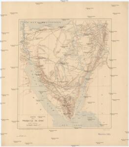
Maps of South Sinai Governorate

Carte de la presqu'ile de Sinai
1 : 1000000 Sinajský poloostrov (Egypt) Service géographique de l'Armée
Geognostische Karte des peträischen Arabien und den südlichen Theiles von Sirien
1 : 880000 Sinajský poloostrov (Egypt) E. Schweizerbart'sche Buchhandlung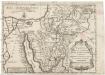
Tabula itineris, et stationum Israelitarum in deserto
1 : 950000 Palestina Starckman, P.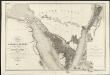
Carte de l'Arabie pétrée
1 : 500000 levée et dressée par Léon de Laborde, en 1828 rectifiée sur les observations astronomiques et les cartes de Niebuhr, Larochette, la Commission d'Egypte, Home, Popham, Valentia, Burckhardt, Erhenberg et Rüppel, et gravée par Collin, pour accompagner le voyage de l'Arabie Petrée Paris : Giard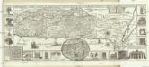
Chorographia Terrae Sanctae in angvstiorem formam redacta, et ex variis avctoribvs a mvltis erroribvs expvrgata
1 : 400000 Izrael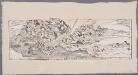
[LL.05413gk], uit: [Palestina] / [Lukas Cranach d. Ä.]
1 : 850000 Annotatie: Onderste deel van de kaart; Van deze kaart is slechts 1 ander (eveneens incompleet) exemplaar bekend (Eran Laor Map Collection, Jeruzalem), waarbij juist het onderste deel van de kaart ontbreekt; Lit.: Cartographica Helvetica, 1991, H. 3, p. 22-27; Print quarterly, vol. 12, no. 2 (1995), p. 123-144 Cranach, Lukas (de Oudere) [Wittenberg : Lukas Cranach d. Ä.]
Carte générale de l'Isthme 1869
1 : 200000 Suezský průplav (Egypt) Migerkov
[Kaart], uit: [Kaart van Zuid-Israel]
1 : 250000 Annotatie: Tekst in het Hebreeuws [S.l. : s.n]
Suez Canal Zone (1954)
Suez Canal Zone, MDR Misc 11944. Overprinted by 42 Svy Eng Reg Nov 1954. Originally classified Restricted. Great Britain. Army. Royal Engineers. Survey Engineers Regiment, 42nd. [S.l.] : [Survey Directorate, Middle East]
Die südliche Galala mit dem nördlichen Theil der krystallinische Küstengebirge am Rothen Meer
1 : 200000 Schweinfurth, Georg Dietrich Reimer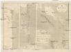
Suez Kanal
1 : 100000 Suezský průplav (Egypt) Reichs-Marine-Amt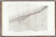
32 El Arich.
1 : 100000 Jacotin, Pierre, 1765-1827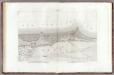
33 Lac Sirbon.
1 : 100000 Jacotin, Pierre, 1765-1827
Egypt 1:100 000
1 : 100000 Sinajský poloostrov (Egypt) Survey of Egypt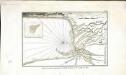
Plan de la partie septentrionale du golfe arabique et de la ville de Suès
1 Karte : Kupferdruck ; 18 x 29 cm Nyon
Sheet XXIV. Palestine Exploration Map.
1 : 63360 Kitchener, H.R. (Horatio Herbert)
22 Suez.
1 : 100000 Jacotin, Pierre, 1765-1827
Plan de la partie inférieure de Ouadi Mousa
Wadi Musa (Jordánsko : údolí) Berthe Gide fills
Red Sea [Harbours and anchorages in the ] (1919)
Harbours and Anchorages in the Red Sea. (Jezirat Farausa.--Strait of Tiran). London : Admiralty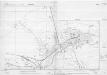
Moascar-Ismailia town plan (1956)
Moascar - Ismailia town plan 1:10 000, GSGS Misc 1753. Great Britain. Ordnance Survey. [S.l.] : [s.n.]
Ismailia [Town plan of] (1955)
Town plan of Ismailia, MDR Misc 11831. Great Britain. Army. Royal Engineers. Survey Engineers Regiment, 42nd. [S.l.] : [Survey Directorate, Middle East]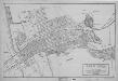
Ismailia [Plan of] (1951)
Plan of Ismailia, MDR Misc 11281. Great Britain. Army. Royal Engineers. Survey Engineers Regiment, 42nd. [Cairo] : [Survey Directorate, Middle East]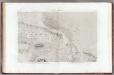
23 Lacs Amers.
1 : 100000 Jacotin, Pierre, 1765-1827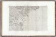
31 Canal de Suez.
1 : 100000 Jacotin, Pierre, 1765-1827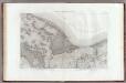
34 Tennis, Peluse, Qatieh.
1 : 100000 Jacotin, Pierre, 1765-1827
Gaza, Palestine
[Palestine]. Great Britain. Army. Royal Engineers. Field Survey Coy., 7th. [S.l.] : printed by Survey of Egypt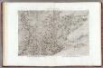
30 Bubaste, Salheih.
1 : 100000 Jacotin, Pierre, 1765-1827
Synoptische tafel der H. Geschiedenis : van Mozes tot aan den tempel van Salomon (1491-1005 vóór Christus) / door H. Lambrecht
Annotatie: Hierop afgebeeld: Kaart voor de geschiedenis der reis van de Joden uit Egypte naar het land van belofte en hunner intrede in dat land. - Schaal: [1:3.000.000]. Palestina tusschen de 12 stammen verdeeld. - Schaal: [1:1.875.000] [S.l. : s.n.] / (Gent : Poelman)
Voyage des Israelites depuis leur sortie d'Egypte.
1 : 3000000 Houze, Antoine Philippe