Maps of Canada
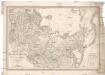
Regiones svb polo arctico / auctore Guiljelmo Blaeu
1 : 13500000 Annotatie: Met wapen; Met opdracht van Joh. Blaeu aan Guilielmus Backer de Corneliis; Origineel is Blad 147 in atlas factice; Annotatie geografische gegevens: Met 3 schaalstokken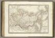
Siberie, Russie d'Asie.
1 : 13500000 Lapie, M. (Pierre), 1779-1850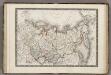
Siberie ou Russie d'Asie.
1 : 18000000 Monin, C.V.
Asie Boreale.
1 : 16500000 Garnier, F. A., 1803-1863
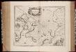
Regiones Sub Polo Arctico. [Karte], in: Novus Atlas, das ist, Weltbeschreibung, Bd. 1, S. 19.
1 Karte aus Atlas Blaeu, Joan Blaeu, Willem Janszoon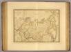
Russie d'Asie.
1 : 13800000 Picquet, C.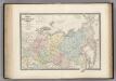
Russie d'Asie.
1 : 14000000 Levasseur, E.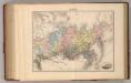
Siberie.
1 : 18700000 Migeon, J.
Extreme Limits of Ice, 1998 - 1938, April - August
U.S. Navy
Karta znergoresursov i zlektrifikacii aziatskoj časti Sojuza SSR
1 : 20000000 Rusko východní Kuzbass, A.
Sibérie ou Russie d'Asie / par C.V. Monin
1 : 18000000 1 Karte : Kupferdruck ; 26 x 38 cm Monin, Charles V. [Perisse Frères]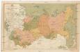
Map of the asiatic part of USSR
1 : 12000000 Rusko východní Mezhdunarodaya Kniga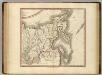
Russian Empire east.
1 : 9400000 Cary, John, ca. 1754-1835
Partie orientale de l'Empire de Russie en Asie / dressée, d'après les cartes de l'Atlas Russien pa
1 : 8500000 1 Karte auf 2 Blatt : Kupferdruck ; 46 x 58 cm Robert de Vaugondy, Didier [Verlag nicht ermittelbar]
Russia in Asia and Tartary.
1 : 19500000 Tanner, Henry S.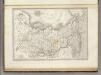
Asie Boreale.
1 : 16500000 Montemont, A.
[140][143] Poli Arctici ..., uit: Atlas sive Descriptio terrarum orbis
Annotatie: Gedigitaliseerde versie. Amsterdam. Heiloo : Picturae (vervaardiger), 2015. tiff-bestand. Gedigitaliseerd: 07-01-2015; Origineel: Universiteitsbibliotheek Vrije Universiteit (XL.05127.-) ; Netherlands; Titelpagina ontbreekt Wit, Frederik de Amsterdam : Frederick de Wit
Russia in Asia.
1 : 30000000 Finley, Anthony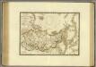
Russie d'Asie et des regions polaires boreales.
1 : 16700000 Brue, Adrien Hubert, 1786-1832
Asiat. Russland.
1 : 33000000 Radefeld, Carl Christian Franz, 1788-1874
Carte Generale de la Russie d'Asie ou Siberie.
1 : 14300000 Vivien de St Martin, L.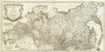
Asie 3.
1 : 7150000 Anville, Jean Baptiste Bourguignon d, 1697-1782
Russia in Asia.
1 : 19800000 Tanner, Henry S.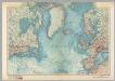
North Atlantic. Pergamon World Atlas.
1 : 15000000 Polish Army Topography Service
Asiatisches Russland.
1 : 17500000 Flemming, Carl
L'Asie 2.
1 : 9500000 Brue, Adrien Hubert, 1786-1832
Regiones Sub Polo Arctico. [Karte], in: Theatrum orbis terrarum, sive, Atlas novus, Bd. 1, S. 31.
1 Karte aus Atlas Blaeu, Joan Blaeu, Willem Janszoon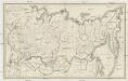
Počtovaja karta rossijskoj imperii
1 : 7100000 Sibiř (Rusko) Frolov
Northern Asia, from the Himalaya Mountains to the Arctic Ocean.
1 : 10771200 Arrowsmith, John