Maps of Belarus
Magni Dvcatvs Lithvaniæ caeterarumq. regionum illi adiacentium exacta descrip ...
1 : 2100000 Annotatie: Rechtsboven genummerd: XVIII; Origineel is Blad 133 in atlas factice; Annotatie geografische gegevens: Met 2 schaalstokken: Milliaria Magna, Milliaria communia [Amsterdam : Sumptibus Janssonio-Waesbergior]
Ostsee-Laender und inneres Russland bis Moskau
1 : 3700000 Moskva-oblast (Rusko) Stülpnagel, Friedrich von Ausfeld, Johann Carl Justus Perthes
Ostsee-Laender und inneres Russland bis Moskau
1 : 3700000 Moskva-oblast (Rusko) Stülpnagel, Friedrich von Ausfeld, Johann Carl Justus Perthes
Prusse, Lithuanie.
1 : 3200000 Clouet, J. B. L. (Jean-Baptiste Louis), b. 1730
Mapa Bělorusi
1 : 2000000 Bělorusko Orsa, A. Karski, Jauchim
Karte der Nationalitätengebiete auf dem Territorium des Grossfürstentums Litauen
Litauen Großfürstentum Litauen ethnische Gruppe Świechowski, Marian von
Lithuania. [Karte], in: Atlas, sive, Cosmographicae meditationes de fabrica mundi et fabricati figura, S. 156.
1 Karte aus Atlas Mercator, Gerhard
Magni Ducatus Lithuaniae [...] [Karte] [Dnipr Fluvius a ptolomeo Borystenes] [Nebenkarte in 2 Teilen], in: Gerardi Mercatoris et I. Hondii Newer Atlas, oder, Grosses Weltbuch, Bd. 1, S. 132.
1 Karte aus Atlas Mercator, Gerhard und Hondius, Jodocus Jansson, Jan
Lithuania. [Karte], in: Gerardi Mercatoris Atlas, sive, Cosmographicae meditationes de fabrica mundi et fabricati figura, S. 161.
1 Karte aus Atlas Mercator, Gerhard Montanus, Petrus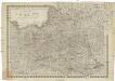
Königreich Pohlen sam[m]t den angränzenden Provinzen
1 : 2060000 Bělorusko Müller, Andreas bey Johann Schönberg
Magni Ducatus Lithuaniae [...] [Karte] [Dnipr Fluvius a ptolomeo Borystenes] [Nebenkarte in 2 Teilen], in: Novus atlas absolutissimus, Bd. 1, S. 99.
1 Karte aus Atlas Janssonius Offizin
Magni dvcatvs Lithvaniae, caeterarvmqve regionvm illi adiacentivm exacta descriptio / sculptum apud
1 : 1300000 1 Karte auf 4 Blatt : Kupferdruck ; 73 x 71 cm Blaeu, Willem Janszoon excudebat Guilhelmus Janssonius sub signo solarij deaurati

Magni Ducatus Lithuaniae, Caeterarumque Regionum Illi Adiacentium Exacta Descriptio [Karte], in: Le théâtre du monde, ou, Nouvel atlas contenant les chartes et descriptions de tous les païs de la terre, Bd. 1, S. 82.
1 Karte aus Atlas Blaeu, Willem Janszoon und Blaeu, Joan Blaeu, Willem Janszoon
Magni Ducatus Lithuaniae, Caeterarumque Regionum Illi Adiacentium Exacta Descriptio [...] [Karte], in: Novus Atlas, das ist, Weltbeschreibung, Bd. 1, S. 68.
1 Karte aus Atlas Blaeu, Joan Blaeu, Willem Janszoon
Polens Umwandelungen von 1772-1809
1 : 2100000 Bělorusko in der Dykischen Buchhandlung
Paasche's Frontenkarte, Nr.6. Der Krieg gegen Russland
Magni Ducatus Lithuaniae, caeterarumque Regionum Illi Adiacentium Exacta Descriptio [Karte], in: Theatrum orbis terrarum, sive, Atlas novus, Bd. 1, S. 84.
1 Karte aus Atlas Blaeu, Joan Blaeu, Willem Janszoon
18. Soviet Republics in North-Central The World Atlas. Europe.
1 : 3000000 USSR (Union of Soviet Socialist Republics).
Royaume de Pologne et duché de Lithuanie
1 : 5180000 Litva Bonne, Rigobert André
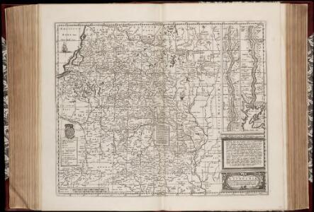
MAGNI DVCATVS | LITHVANIÆ | et Regionum Adiacentium
exacta Descriptio | Ill.mi ac Excell.mi Principis et Dni. D. Nicolai Christophori Radziwil... opera, cura et impensis olim facta, ac nunc denuo hac forma edita a I. Blaeu. Ioannes Blaeu | Excudebat.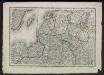
Voenno-dorožnaja karta časti Rossii i pograničnych zemelʹ
1 : 1680000 Baltikum, Ostpreußen Šubert [Generalmajor]
Magni dvcatvs Lithvaniae, et regionum adiacentium exacta descriptio
1 : 2000000 Bělorusko Blaeu, Joan I. Blaeu
Polens Umwandelungen von 1772-1809
1 : 2100000 Polsko zu finden in der Dykischen Buchhandlung
Carte de Nouve au Royaume de Polonge.
1 : 4500000 Vivien de St Martin, L.
Karta voennych dějstvīj 1768 - 1771 i 1794 g.g.
Polen Krieg
Het Koningkryk Polen, volgens de nieuwste waarneminge opgesteld
1 : 16000000 te Amsterdam : bij S. v. Esveldt
Baltic States & East Prussia.
1 : 2000000 John Bartholomew and Son
Magn[us] dvcatvs Litvaniae
1 : 1630000 Bělorusko Nieprzecki, Jan Mayer, Tobias impensis Homannianorum Heredum