Maps of Spain

Totius regnorum Hispaniae et Portugaliae descriptio / auct. F. de Wit
1 : 2500000 Annotatie: Origineel is Blad 5 in atlas factice Wit, Frederik de Gedruckt tot Amsterdam : by Frederick de Wit ...
Typus Hispaniae [Karte], in: Gerardi Mercatoris et I. Hondii Newer Atlas, oder, Grosses Weltbuch, Bd. 2, S. 168.
1 Karte aus Atlas Mercator, Gerhard und Hondius, Jodocus Jansson, Jan

Regnorum Hispaniae nova descriptio. [Karte], in: Theatrum orbis terrarum, sive, Atlas novus, Bd. 2, S. 192.
1 Karte aus Atlas Blaeu, Joan Blaeu, Willem Janszoon
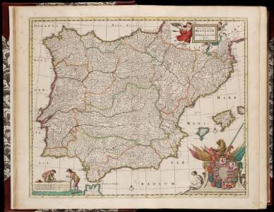
Hispaniae et Portugalliae Regna / per Nicolaum Visscher
1 : 2500000 Annotatie: Cum privilegio; Origineel is Blad 4 in atlas factice Nicolaes Jansz. Visscher jr. 1649-1702 [Amsterdam : Nicolaes Visscher]
Weg-wyzer der legertogten in Spanje en Portugaal
1 Karte : Kupferdruck ; 49 x 57 cm Allard Abraham Allard
Accuratissima totius regni Hispaniæ Portugalliæ[que] tabula et typus novissimus
1 Karte : Kupferdruck ; 48 x 57 cm Wit ex officina Frederici de Witt
Novissima regnorum Hispaniæ et Portugalliæ tabula
1 Karte : Kupferdruck ; 48 x 56 cm Homann; Funck edita per Davidem Funcken
Hispaniae et Portugalliae regna [et]c
1 Karte : Kupferdruck ; 48 x 56 cm Homann; Funck ex officina Davidis Funckii
Hispaniæ et Portugalliæ regna
1 Karte : Kupferdruck ; 45 x 55 cm Visscher s.n.
Accuratissima totius regni Hispaniæ tabula
1 Karte : Kupferdruck ; 48 x 56 cm Danckerts ex officina Justi Danckerts
Accuratissima totius regni Hispaniae tabula
1 : 2400000 1 Karte : Kupferdruck ; 48 x 56 cm Danckerts, Justus [Danckerts]
Spanien, Portugal.
1 : 4900000 Haller von Hallerstein, Friedrich
Novissima et accuratissima regnorum Hispaniæ et Portugalliæ mappa geographica
1 Karte : Kupferdruck ; 48 x 56 cm Seutter; Probst anjezo in Verlag bey Ioh. Michael Probst chalcogr
Novissima et accuratissima regnorum Hispaniæ et Portugalliæ tabula
1 Karte : Kupferdruck ; 48 x 58 cm Wit ex officina I. Covens et C. Mortier
Novissima et accuratissima regnorum Hispaniæ et Portugalliæ tabula
1 Karte : Kupferdruck ; 48 x 58 cm Wit s.n.
Spanien und Portugal
Handatlas über alle Theile der Erde und über das Weltgebäude Stieler, Adolf Justus Perthes
Hispaniarum Portugalliæque coronarum typus novus
1 Karte : Kupferdruck ; 48 x 59 cm Valck s.n.
Regnorum Hispaniae nova descriptio. [Karte], in: Novus Atlas, das ist, Weltbeschreibung, Bd. 2, S. 196.
1 Karte aus Atlas Blaeu, Joan Blaeu, Willem Janszoon
Spanien und Portugal
Hand-Atlas über alle Theile der Erde nach dem neuesten Zustande und über das Weltgebäude Stieler, Adolf bei Justus Perthes
L'Espagne
1 Karte : Kupferdruck ; 44 x 58 cm Jaillot; Ottens; Ottens chez R. et J. Ottens
L'Espagne
1 Karte : Kupferdruck ; 44 x 58 cm Jaillot s.n.
L'Espagne
1 Karte : Kupferdruck ; 44 x 58 cm Jaillot s.n.
Accuratissima totius regni Hispaniæ et Portugalliæ tabula
1 Karte : Kupferdruck ; 45 x 57 cm Schenk; Sanson s.n.
Spanjen en Portúgal
1 : 6000000 [S.l. : s.n.]
Mapa general de España
1 Karte : Kupferdruck ; 48 x 58 cm López Tomás López
Regnorum Hispaniæ et Portugalliæ tabula generalis
1 Karte : Kupferdruck ; 47 x 55 cm Homann Johann Baptist Homann
Typus Hispaniae ab Hesselo Gerardo delineata [...] [Karte], in: Novus atlas absolutissimus, Bd. 6, S. 15.
1 Karte aus Atlas Janssonius Offizin
L'Espagne
1 Karte : Kupferdruck ; 40 x 52 cm Sanson; Mariette; Cordier chez Pierre Mariette rüe S. Iacques à l'esperance