Maps of powiat lwówecki

150 Hirschberg, uit: Topographische Special-Karte von Deutschland (von Central-Europa) / begründet von D.G. Reymann ; [entworfen und gezeichn. von Heinrich Berghaus... [et al.]]
1 : 200000 Annotatie: Lit.: Daniel Gottlob Reymann und die "Topographische Special-Karte von Deutschland" / von Wolfgang Scharfe, in: Kartographische Nachrichten, 39 (1989), Heft I, p. 1-10; Handgeschreven titel: Reymann's Deutschland : 24 Sectionen: Jena, Penig, Dresden, Zittau, Hirschberg, Breslau, Brieg, Andernach, Coblenz, Giessen, Fulda, Schleusingen, Plauen, Zwickau, Teplitz, Jung Bunzlau, Hohenelbe, Glatz, Neisse, Simmern, Prag, Luxemburg, Birkenfeld; Aanwezig: 23 bladen Reymann, Daniel Gottlob; Berghaus, Heinrich [Berlin : 2. Departement des Kriegsministeriums, Bureau für Plan- und Kartenzeichnung]

Karte des Riesengebirges
1 : 200000 Krkonoše (Česko a Polsko : pohoří : oblast) Reymann, Gottlob Daniel C. Flemming
Liegnitz-Hirschberg (Riesengebirge)
1 : 100000 Jelení Hora-oblast (Polsko) Reichsamt für Landesaufnahme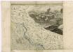
Müllerova mapa Čech
1 : 132000
Straubes offizielle farbige Wegekarte vom Riesen- und Isergebirge
1 : 120000 Adršpach (Česko : oblast) Straube, Julius Geogr. Institut u. Landkarten-Verlag Jul. Straube
II. vojenské mapování 4
1 : 144000
II. vojenské mapování 4
1 : 144000
Harrachsdorf.
from Spezialkarte der osterreichisch-ungarischen Monarchie.
III. vojenské mapování 3655
1 : 75000
Der preussische Antheil des Riesengebirges
1 : 100000 Krkonoše (Česko a Polsko) Vogel von Falckenstein, Eduard C. Flemming
Harrachov a Hirschberg
1 : 75000 Harrachov (Semily, Česko : oblast) Vojenský zeměpisný ústav
Harrachov a Hirschberg
1 : 75000 Harrachov (Semily, Česko : oblast) Vojenský zeměpisný ústav
Harrachov
1 : 75000 Harrachov-oblast (Semily, Česko) Vojenský zeměpisný ústav
Harrachov a Hischberg
1 : 75000 Harrachov (Semily, Česko : oblast) Vojenský zeměpisný ústav
Die Schlacht an der Katzbach den 26ten August 1813
1 : 25000 Rahden, Wilhelm von; Brose, Karl Heinrich; Prêtre, Jean Gabriel Pretre
Riesengebirge
1 : 40000 Cieplice Śląskie Zdrój (Polsko) Klimesch, F. Alexius Kiessling

Neue Specialkarte vom Riesengebirge
1 : 50000 Krkonoše (Česko a Polsko) Liebenow, Wilhelm Max Pasch
Zum Hinterhalt bei Haynau 26. Mai 1813


Meßtischblatt 3011 : Ruhbank, 1936
1 : 250000 Ruhbank. - Hrsg. 1886, bericht. 1936. - 1:25000. - [Berlin]: Reichsamt für Landesaufnahme, 1936. - 1 Kt.
Meßtischblatt 3011 : Ruhbank, 1933
1 : 250000 Ruhbank. - Hrsg. 1886, bericht. 1925, gedr. [19]33. - 1:25000. - [Berlin]: Reichsamt für Landesaufnahme, 1933. - 1 Kt.
Meßtischblatt 3010 : Kupferberg (Riesengeb.), 1934
1 : 250000 Kupferberg (Riesengeb.). - Hrsg. 1886, bericht. 1924. - 1:25000. - [Berlin]: Reichsamt für Landesaufnahme, 1934. - 1 Kt.
Meßtischblatt 5160 : Bad Warmbrunn, 1937
1 : 250000 Bad Warmbrunn. - Hrsg. 1886, bericht. 1937. - 1:25000. - [Berlin]: Reichsamt für Landesaufnahme, 1937. - 1 Kt.
Meßtischblatt 3008 : Schreiberhau, 1930
1 : 250000 Schreiberhau. - Hrsg. 1886, bericht. 1924, einz. Nachtr. 1930. - 1:25000. - [Berlin]: Reichsamt für Landesaufnahme, 1930. - 1 Kt.
Meßtischblatt 5158 : Bad Flinsberg, 1942
1 : 250000 Bad Flinsberg. - Aufn. 1884, hrsg. 1885, bericht. 1938. - 1:25000. - [Berlin]: Reichsamt für Landesaufnahme, 1942. - 1 Kt.
Meßtischblatt 5062 : Bolkenhain, 1938
1 : 250000 Bolkenhain. - Aufn. 1884, hrsg. 1886, bericht. 1936. - 1:25000. - [Berlin]: Reichsamt für Landesaufnahme, 1938. - 1 Kt.
Meßtischblatt 2949 : Bolkenhain, 1934
1 : 250000 Bolkenhain. - Hrsg. 1886, bericht. 1925, Nachtr. 1930, gedr. [19]34. - 1:25000. - [Berlin]: Reichsamt für Landesaufnahme, 1934. - 1 Kt.
![150 Hirschberg, uit: Topographische Special-Karte von Deutschland (von Central-Europa) / begründet von D.G. Reymann ; [entworfen und gezeichn. von Heinrich Berghaus... [et al.]]](https://images-2.georeferencer.com/images/iiif/869240512967/full/,300/0/native.jpg)

