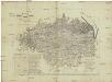
Maps of gmina Mirsk

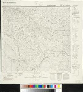
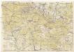
Meßtischblatt 5158 : Bad Flinsberg, 1942
1 : 250000 Bad Flinsberg. - Aufn. 1884, hrsg. 1885, bericht. 1938. - 1:25000. - [Berlin]: Reichsamt für Landesaufnahme, 1942. - 1 Kt.
[Kartenblatt]
1 : 25000 Harrachov (Semily, Česko : oblast) Reichsamt für Landesaufnahme
[Gradkartenblatt]
1 : 25000 Harrachov-oblast (Semily, Česko) Vojenský zeměpisný ústav
III. vojenské mapování 3655/3
1 : 25000
III. vojenské mapování 3655/3
1 : 25000
III. vojenské mapování 3655/3
1 : 25000
Harrachov a Hirschberg
1 : 75000 Harrachov (Semily, Česko : oblast) Vojenský zeměpisný ústav
Harrachov a Hirschberg
1 : 75000 Harrachov (Semily, Česko : oblast) Vojenský zeměpisný ústav
Mapka Jizerských hor
1 : 150000 Jizerské hory (Česko a Polsko : oblast) Ed. Grégr
III. vojenské mapování 3655
1 : 75000
Iser-Gebirge
1 : 75000 Jizerské hory (Česko a Polsko : oblast) Alexander Köhler
Harrachov
1 : 75000 Harrachov-oblast (Semily, Česko) Vojenský zeměpisný ústav
Harrachov a Hischberg
1 : 75000 Harrachov (Semily, Česko : oblast) Vojenský zeměpisný ústav
Karte des Bezirkes Friedland

Meinhold's Wintersportkarte vom Riesengebirge
1 : 50000 Krkonoše (Česko a Polsko) Winkler, P. C.C. Meinhold & Söhne
Karte vom Riesen-Gebirge
1 : 100000 Krkonoše (Česko a Polsko : pohoří : oblast) Grieben-Verlag
Harrachsdorf.
from Spezialkarte der osterreichisch-ungarischen Monarchie.
Der preussische Antheil des Riesengebirges
1 : 100000 Krkonoše (Česko a Polsko) Vogel von Falckenstein, Eduard C. Flemming
Riesen - Gebirge

Charte vom Riesengebirge
1 : 160000 Krkonoše (Česko a Polsko) Mattis, Carl Klinkert, F. C. Mattis
Neueste Specialkarte vom Riesengebirge
1 : 50000 Krkonoše-oblast (Česko a Polsko) Mittelbach, R. Mittelbach's Verlag
Neueste Specialkarte vom Riesengebirge
1 : 50000 Krkonoše-oblast (Česko a Polsko) Mittelbach, R. Mittelbach's Verlag
Neueste Specialkarte vom Riesengebirge
1 : 50000 Krkonoše-oblast (Česko a Polsko) Mittelbach, R. Mittelbach's Verlag
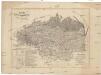
Karte der Bezirkshauptmannschaft Friedland
1 : 100000 Frýdlant-oblast (Česko) Erben, Josef Karl Janský
Krkonoše
Meinhold's Wanderkarte vom Riesengebirge
1 : 50000 Krkonoše (Česko a Polsko) Winkler, P. C.C. Meinhold & Söhne
Krkonoše

Karte der Reichenberger Bezirkshauptmannschaft
1 : 70000 Liberec-oblast (Česko) Medau, Karel Vilém Lehrpersonale der Leitmeritzer k.k. Hauptschule