Maps of Piechowice

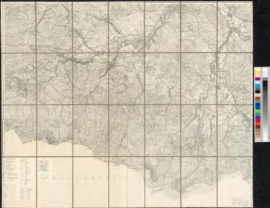
Meßtischblatt 3008 : Schreiberhau, 1930
1 : 250000 Schreiberhau. - Hrsg. 1886, bericht. 1924, einz. Nachtr. 1930. - 1:25000. - [Berlin]: Reichsamt für Landesaufnahme, 1930. - 1 Kt.
Harrachov
1 : 75000 Harrachov-oblast (Semily, Česko) Vojenský zeměpisný ústav
Harrachov a Hischberg
1 : 75000 Harrachov (Semily, Česko : oblast) Vojenský zeměpisný ústav
Harrachov a Hirschberg
1 : 75000 Harrachov (Semily, Česko : oblast) Vojenský zeměpisný ústav
Harrachov a Hirschberg
1 : 75000 Harrachov (Semily, Česko : oblast) Vojenský zeměpisný ústav
Wintersportkarte vom Riesengebirge
1 : 75000 Krkonoše-oblast (Česko a Polsko) Mittelbach, R. Mittelbach's Verlag
III. vojenské mapování 3655
1 : 75000
Charte vom Riesengebirge
1 : 160000 Krkonoše (Česko a Polsko) Mattis, Carl Klinkert, F. C. Mattis
Der preussische Antheil des Riesengebirges
1 : 100000 Krkonoše (Česko a Polsko) Vogel von Falckenstein, Eduard C. Flemming
Riesen-Gebirge
1 : 75000 Krkonoše-oblast (Česko a Polsko) Brey, Otto Alexander Köhler
Neueste Specialkarte vom Riesengebirge
1 : 50000 Krkonoše-oblast (Česko a Polsko) Mittelbach, R. Mittelbach's Verlag
Neueste Specialkarte vom Riesengebirge
1 : 50000 Krkonoše-oblast (Česko a Polsko) Mittelbach, R. Mittelbach's Verlag
Neueste Specialkarte vom Riesengebirge
1 : 50000 Krkonoše-oblast (Česko a Polsko) Mittelbach, R. Mittelbach's Verlag
Meinhold's Wintersportkarte vom Riesengebirge
1 : 50000 Krkonoše (Česko a Polsko) Winkler, P. C.C. Meinhold & Söhne
Riesen - Gebirge

Karte vom Riesen-Gebirge
1 : 100000 Krkonoše (Česko a Polsko : pohoří : oblast) Grieben-Verlag
Harrachsdorf.
from Spezialkarte der osterreichisch-ungarischen Monarchie.
Neue Specialkarte vom Riesengebirge
1 : 50000 Krkonoše (Česko a Polsko) Liebenow, Wilhelm Max Pasch
Meinhold's Wanderkarte vom Riesengebirge
1 : 50000 Krkonoše (Česko a Polsko) Winkler, P. C.C. Meinhold & Söhne
Krkonoše
Krkonoše

Riesengebirge
1 : 50000 Krkonoše-oblast (Česko a Polsko) Winkler, P. C.C. Meinhold & Söhne
Riesengebirge
1 : 50000 Krkonoše-oblast (Česko a Polsko) Winkler, P. C.C. Meinhold
[Kartenblatt]
1 : 25000 Harrachov (Semily, Česko : oblast) Reichsamt für Landesaufnahme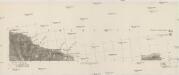
[Gradkartenblatt]
1 : 25000 Krkonoše (Česko a Polsko) Vojenský zeměpisný ústav

Relief-Wanderkarte vom Riesengebirge
1 : 50000 Krkonoše (Česko a Polsko) Bienert, Richard Richard Bienert
III. vojenské mapování 3655/3
1 : 25000
III. vojenské mapování 3655/3
1 : 25000