Maps of South Holland
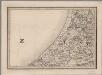
[10], uit: Hydro-Oro und Chorographische General Karte des Koenigreichs der Niederlande und der angrenzenden Länder bis Paris : mit der Angabe der Kunst und Heer-Strassen und der Entfernung der Poststationen / ... zusammengetragen und reducirt von ... Wilhelm Müller
1 : 400000 titelvariant: Generalkarte des Koenigreichs Hannover; Annotatie: 1e supplement bij: Generalkarte des Koenigreichs Hannover (1818) Müller, Wilhelm (fl. 1818) [Hannover : Wilhelm Müller]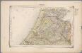
14. Rijnland, uit: Geologische kaart van Nederland / door W.C.H. Staring ; bew. aan de Topographische Inrichting
1 : 200000 Winand Carel Hugo Staring 1808-1877; Topographische Inrichting, 's-Gravenhage 's-Gravenhage : Belinfante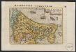
Hollandia
1 : 1100000 [Pieter van den Keere] [Middelburg etc.] : [Barent Langenes etc.]
[Kaart], uit: Zuid-Holland / lith. J. Smulders
1 : 140000 titelvariant: Sleeswijk's kaart van Zuid Holland; Annotatie: Omslagtitel: Sleeswijk's kaart van Zuid Holland : naar officieele gegevens bewerkt : voor wandelaars, wielrijders en automobilisten : voor school, kantoor en huiskamer; Verso: plaatsnamenregister J. Smulders & Co., 's-Gravenhage Bussum : Sleeswijk
Zuid-Holland, uit: Sterfte-atlas van Nederland over 1860-1874 / [uitgave van de Nederlandsche Maatschappij tot Bevordering der Geneeskunst]
titelvariant: Sterfte-atlas van Nederland; Annotatie: Alleen kaartbijlage aanwezig Pieter Harmen Witkamp 1816-1892; Nederlandsche Maatschappij tot Bevordering der Geneeskunst Amsterdam : van Rossen
Tabula nova Hollandiæ Meridionalis vulgo Zuid-Holland ad usum serenissimi Burgundiæ ducis
1 : 230000 [Pieter Mortier] Parisiis [i.e. Amsterdam] : [Pieter Mortier]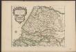
Partie meridionale du Comté de Hollande
1 : 230000 dressé sur les memoires les pl[us] recents, par le sr. Sanson, geographe ordinaire du roy L. Cordier sculp. A Paris : chez H. Jaillot ...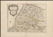
Partie meridionale du Comté de Hollande
1 : 230000 dressé sur les memoires les pl[us] recents, par le sr. Sanson, geographe ordinaire du roy L. Cordier sculp. A Paris : chez H. Jaillot ... [i.e. anonymous publisher]
Partie meridionale du Comté de Hollande
1 : 230000 dressé sur les memoires les pl[us] recents, par le sr. Sanson, geographe ordinaire du roy L. Cordier sculp. A Paris : chez H. Jaillot ...
Partie méridionale du Comté de Hollande.
1 : 160000 [S.l.] : [s.n.]
Partie Meridionale Du Comte De Hollande
1 : 230000 Mollova mapová sbírka Sanson, Guillaume Cordier, Louis Jaillot, Alexis Hubert
La Rhinlande Amstellande et terres circõvosines
1 : 300000 auctore Balt[hasar] Flo: a Berkêrode. [Amsterdam] : [Jacob Aertsz. Colom]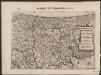
Rhinolandiæ Amstelandiæ et circumjacent. aliquot territoriû accurata descriptio
1 : 360000 Auctore Balth. Florentio a Berckenrode. Amstelodami : sumptibus Henrici Hondii.
Rhenolandia, Amstelandia Et Circumiacentia aliquot Territoria, cum Aggeribus omnibus, Terminisque suis. [Karte], in: Novus atlas absolutissimus, Bd. 3, S. 179.
1 Karte aus Atlas Janssonius Offizin

Rhenolandia, Amstelandia et circumjacentia aliquot territoria, cum aggeribus omnibus, terminisq[ue] suis / accurate et distincte edita per Nicolaum Visscher
1 : 180000 Annotatie: Cum privilegio Ordinum Hollandiae et West-Frisiae; Met opdracht van Nicolaus Visscher aan Johannes Hudde; Annotatie geografische gegevens: West boven; Met 2 schaalstokken Nicolaes Jansz Visscher sr 1618-1679 [Amsterdam : Nicolaus Visscher]
[Kaart], uit: Zuid-Holland / ontworpen en get. door J. Kuyper ; D. Veelwaard sculps.
1 : 200000 titelvariant: Kaart van Zuid-Holland; Annotatie: Omslagtitel: Kaart van Zuid-Holland Kuyper, Jacob; Veelwaard, Daniel (jr.) Zwolle : Tjeenk Willink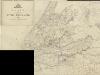
Kaart van de provincie Zuid-Holland
1 : 50000 opgemaakt op last van de Provinciale Staten. ['s-Gravenhage] : Provinciale Staten
Rhenolandia, Amstelandia et circumjacentia aliquot territoria, cum aggeribus omnibus terminisque suis
1 : 180000 accurate et distincte edita per Nicolaum Visscher. [Amsterdam] : [N. Visscher]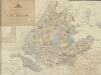
Kaart van de provincie Zuid Holland
1 : 50000 opgemaakt op last van de Provinciale Staten. ['s-Gravenhage] : Provinciale Staten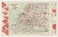
Zuid-Holland, uit: [Provinciale fietskaart ...]
Annotatie: Boven en onder het kaartbeeld verkeersborden voor wielrijders; Provincienaam op voorkant geflankeerd door provinciewapen en wapen van de provinciehoofdstad, waaronder een stadsbeeld met fietser in klederdracht; Kaart van Overijssel ontbreekt Deventer : Burgers E.N.R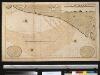
De kust van Holland van Texel tot de Maas
Netherlands Gerard van Keulen
[Kaart], uit: Kaart van Zuid-Holland : voor wandelaars, wielrijders en automobilisten / lith. J. Smulders
1 : 133000 J. Smulders & Co., 's-Gravenhage Bussum : Sleeswijk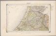
14. Rijnland, uit: Geologische kaart van Nederland / door W.C.H. Staring ; bew. aan de Topographische Inrichting
1 : 200000 Winand Carel Hugo Staring 1808-1877; Topographische Inrichting, 's-Gravenhage 's-Gravenhage : Belinfante
Rhenolandia, Amstelandia et circumjacentia aliquot territoria, cum aggeribus omnibus, terminisq. suis
1 : 180000 accurate et distincte edita per Nicolaum Visscher. [Amsterdam] : nunc apud Petrum Schenk Junior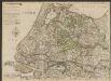
Nieuwe kaart van Holland, Utrecht, de Vyf Heeren Landen en een gedeelte van Gelderland. naar de nieuwste waarnemingen geteekent
1 : 175000 [C. Cóvens, delin.] [C. van Baarsel, sculpt. 1792] Te Amsterdam : by Iohannes Covens en Zoon
Rhenolandiae et Amstellandiae exactiβima Tabula. [Karte], in: Novus Atlas, das ist, Weltbeschreibung, Bd. 1, S. 394.
1 Karte aus Atlas Blaeu, Joan Blaeu, Willem Janszoon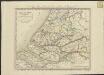
Hollande méridionale, divisée en arrondissemens et cantons de justice de paix
1 : 175000 dressée et gravée par C. van Baarsel et fils. A Amsterdam et a La Haye : chez F.J. Weygand ...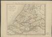
![[10], uit: Hydro-Oro und Chorographische General Karte des Koenigreichs der Niederlande und der angrenzenden Länder bis Paris : mit der Angabe der Kunst und Heer-Strassen und der Entfernung der Poststationen / ... zusammengetragen und reducirt von ... Wilhelm Müller](https://images-2.georeferencer.com/images/iiif/395096606936/full/,300/0/native.jpg)

