Maps of Zuid-Holland
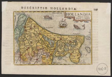
Hollandia
1 : 1100000 [Pieter van den Keere] [Middelburg etc.] : [Barent Langenes etc.]
Hollandia
1 : 970000 [Pieter van den Keere engraver] [Arnhem etc.] : [Jan Jansz. etc.]
Hollandia
1 : 1500000 [Jodocus Hondius jr. engraver] [Amsterdam] : [Jodocus Hondius jr.]
Hollandia Comitatus
1 : 990000 [Pieter van den Keere engraver] [Amsterdam] : Johannes Janssonius]
Hollandia
1 : 950000 [Jodocus Hondius sr. engraver] [Amsterdam etc.] : [Jodocus Hondius sr. etc.]
Hollandia
1 : 950000 [Jodocus Hondius sr. engraver] [Amsterdam etc.] : [Jodocus Hondius sr. etc.]
Comitatus Hollandia
1 : 1200000 [Abraham Goos engraver] [Amsterdam etc.] : [Abraham Goos etc.]
Tabvla comitatvs Hollandiæ
1 Karte : Kupferdruck ; 57 x 48 cm Rupert Homännische Erben
Tabvla comitatvs Hollandiæ
1 Karte : Kupferdruck ; 56 x 48 cm Homännische Erben
Tabvla comitatvs Hollandiæ
1 Karte : Kupferdruck ; 57 x 48 cm Homännische Erben
Le Comté de Hollande
1 : 240000 dressé sur les memoires les plus nouveaux par le Sr. Sanson, geographe ordinaire du roy presenté à ... le Dauphin ... par ... Alexis Hubert Jaillot. A Amsterdam : chez I. Cóvens et C. Mortier
Tabvla Comitatvs Hollandiae
1 : 300000 Mollova mapová sbírka Homann, Johann Baptist Homann, Johann Baptista - dědici
Comitatus Hollandiae tabula pluribus locis
1 : 308000 Nizozemsko Visscher, Nicolaes Jansz. Schenk, Pieter apud Petrum Schenk Junior
Comitatus Hollandiae tabula pluribus locis
1 : 308000 Nizozemsko Wit, Frederick de by Frederick de Wit
Charte von Holland
1 Karte : Kupferdruck ; 55 x 43 cm Güssefeld by den Hom. Erben
Tabula Comitatus Hollandiæ cum ipsius consinijs Dominii nimirum Ultraiectini nec non Geldriæ et Frisiæ geographice tradita curis
1 : 300000 [Homann Heirs] Norib. : Homannianorum Heredum
Comitatus Hollandiae Tabula Pluribus Locis
1 : 500000 Mollova mapová sbírka Wit, Frederik de Covens, Johannes I
Holland
1 : 440000 [François Halma] [Leeuwarden] : [Henrik Halma]
Hollandiae Antiqvorvm Catthorvm Sedis Nova Descriptio
1 : 370000 Mollova mapová sbírka Deventer, Jacob van
Hollandiae Antiqvorvm Catthorvm Sedis Nova Descriptio
1 : 370000 Mollova mapová sbírka Deventer, Jacob van
Carte du Comté de Hollande
1 : 700000 [Jacques Nicolas Bellin] [Paris] : [Jacques Nicolas Bellin]
Hollandt comtitatus Utreicht episcop: [Karte], in: Gerardi Mercatoris Atlas, sive, Cosmographicae meditationes de fabrica mundi et fabricati figura, S. 299.
1 Karte aus Atlas Mercator, Gerhard Montanus, Petrus

Hollandt comitatus Utricht episcop:
1 : 340000 per Gerardum Mercatorem. [Amsterodami] : [Henricus Hondius]
Hollandt comitatus Utricht episcop:
1 : 340000 per Gerardum Mercatorem. [Duisburg] : [Henricus Hondius]
Nieuwe kaart van het departement van Texel, verdeeld in VII ringen
1 : 400000 C. Covens del. C. van Baarsel sculp. Te Amsterdam : bij Mortier Covens en Zoon
Hollandia Comitatvs
1 : 530000 Mollova mapová sbírka Merian, Caspar Merian, Caspar
[10], uit: Hydro-Oro und Chorographische General Karte des Koenigreichs der Niederlande und der angrenzenden Länder bis Paris : mit der Angabe der Kunst und Heer-Strassen und der Entfernung der Poststationen / ... zusammengetragen und reducirt von ... Wilhelm Müller
1 : 400000 titelvariant: Generalkarte des Koenigreichs Hannover; Annotatie: 1e supplement bij: Generalkarte des Koenigreichs Hannover (1818) Müller, Wilhelm (fl. 1818) [Hannover : Wilhelm Müller]
Directions for sailing into the Texel
1 : 160000 by John Dieteric Trock of Hamburg. [S.l.] : [s.n.]