Maps of Antwerp
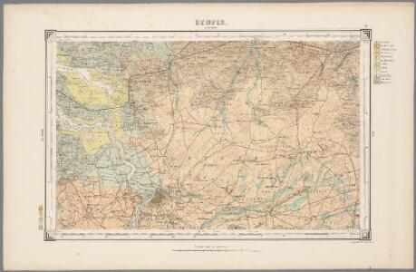
22. Kempen, uit: Geologische kaart van Nederland / door W.C.H. Staring ; bew. aan de Topographische Inrichting
1 : 200000 Winand Carel Hugo Staring 1808-1877; Topographische Inrichting, 's-Gravenhage 's-Gravenhage : Belinfante
17, uit: Topografische atlas van het Koninkrijk der Nederlanden
Annotatie: Map met 19 losse krt. schaal 1:200.000 en 1 bladwijzer schaal 1:1.000.000 ['s-Gravenhage : Ministerie van Oorlog, Topografisch Bureau]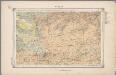
22. Kempen, uit: Geologische kaart van Nederland / door W.C.H. Staring ; bew. aan de Topographische Inrichting
1 : 200000 Winand Carel Hugo Staring 1808-1877; Topographische Inrichting, 's-Gravenhage 's-Gravenhage : Belinfante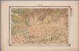
22. Kempen, uit: Geologische kaart van Nederland : schaal van 1:200.000 / door W.C.H. Staring ; uitgevoerd door het Topographisch Bureau van Oorlog ; uitgegeven op last van Zijne Majesteit Den Koning
Annotatie: Impressum ontleend aan omslag; Kaart "Nederland de dijken weggedacht" [kaart 25] en kaart 13 (bladwijzer) vermelden het jaar 1869; Kaart 'Limburg en de Hesbaije' (bladnr. 26) vermeldt het jaar 1868; Blad 5/9 ontbreekt Topographische Inrichting, 's-Gravenhage; Topographisch Bureau Haarlem : A.C. Kruseman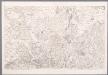
III, uit: Carte chorographique des Pays-Bas Autrichiens / ... par le Comte de Ferraris ; gravée par L.A. Dupuis
1 : 86400 Annotatie: Lit.: Les militaires et la cartographie des Pays-Bas méridionaux et de la Principauté de Liège à la fin du XVIIe et au XVIII siècle / Claire Lemoine-Isabeau. - Bruxelles, 1984, p. 206-212; La cartographie au XVIIIe siècle et l'oeuvre du Comte de Ferraris (1726-1814) : colloque international, Spa, 8-11 sept. 1976. - Bruxelles, 1978; Met opdracht aan keizer Joseph II (bl.XVI); Met plattegrond van Brussel (bl. XXI), overzichtskaart (bl. XXII) en bladwijzer (bl. XXIII); Ontbreekt: bl. I-III en XXI; Voor aanwezige bladen zie overzichtsblad Ferraris, Johann Joseph; Dupuis, L. A. [S.l. : s.n.]
III ; 1.K., uit: Carte chorographique des Pays-Bas Autrichiens / ... par le Comte de Ferraris ; gravée par L.A. Dupuis
1 : 86400 Annotatie: Bladen linksboven genummerd met Romeinse cijfers, rechtsboven met een cijfer en een letter; Met opdracht aan keizer Joseph II (bl.XVI); Met plattegrond van Brussel (bl. XXI), overzichtskaart (bl. XXII) en bladwijzer (bl. XXIII); Annotatie geografische gegevens: Schaalstokken: Echelle de Toises ou de Lieues communes de France; Echelle de Verges ou de Lieues de Brabant; Echelle de Milles d'Allemagne (bl. XVII); Echelle de Mètres; In de hoeken lengte- en breedtematen T.M.e en T.P.e Joseph-Jean François Ferraris Comte de 1726-1814; L.A. Dupuis [S.l. : s.n.]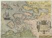
Zelandicarvm Insvlarvm exactissima et nova descriptio
1 : 270000 Mollova mapová sbírka Deventer, Jacob van
Road and Bridge Map: Antwerp
1 : 100000 First World War Road and Bridge Map. Antwerp. Showing roads normally suitable for motor traffic, road bridges and light railways. War Office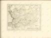

Brabantiae Batavae Pars Occidentalis
1 : 133000 Mollova mapová sbírka Visscher, Nicolaes Schenk, Peter II
Brabantiae Pars Septentrionalis
1 : 170000 Mollova mapová sbírka Wit, Frederik de Covens, Johannes I
Brabantiae Batavae pars occidentalis, sive Antverpiensis tetrarchiae pars septentrionalis, comprehendens Baroniam Bredanam, Marchionatum Bergensem ad Zomam, aliasque minores ditiones
1 : 125000 per Nicolaum Visscher. [Amsterdam] : nunc apud Petrum Schenk Junior
Zeelandia Comitatvs
1 : 490000 Mollova mapová sbírka Merian, Caspar Merian, Caspar - dědici
Bl. 31 Chaam, 1905, uit: Atlas A.N.W.B.
1 : 200000 titelvariant: Atlas van Nederland van den A.N.W.B. Toeristenbond voor Nederland; Wielrijders-atlas van Nederland; Annotatie: Titel op bladwijzer: Atlas van Nederland van den A.N.W.B. Toeristenbond voor Nederland; Titel op legendablad: Wielrijders-atlas van Nederland; Voor aanwezige bladen zie overzichtsblad; Annotatie geografische gegevens: De serie bestaat uit 36 bladen ANWB ['s-Gravenhage : A.N.W.B.]
Nieuwe caert vande ghelegentheyt oost en wester Schelde vertoonde ock de verdroncken ouerwaterde lande nieu angevassen schorer, e[e]n kreeke[e] oft killen in e[e]n door selve tussche[e] Bergen en Antwerpen soo het nu is. 1638
1 : 100000 Antverpy (Belgie) Bist, Peter ver Peter ver Bist
Brabantiae Batavae pars occidentalis sive Antverpiensis tetrarchiae pars septentrionalis, comprehendens baroniam Bredanam, marchionatum Bergensem ad Zomam, aliasq. minores ditiones
1 : 130000 Antverpy (Belgie) Visscher, Nicolaus Schenk, Pieter apud Petrum Schenk junior
22me Tilburg, uit: Nouvelle carte de la Hollande, d'après Kraijenhoff et les meilleures cartes connues / Établissement Géographique de Bruxelles, fondé par Ph. Vander Maelen
1 : 117000 Annotatie: De bladen zijn genummerd 1-24. De bladen 2 t/m 24 hebben elk een afzonderlijke titel. Blad 5 bevat: Triangulations et positions. Blad 9 bevat: Plan d'Amsterdam; De kaartbladen 1, 5, 9 en 24 zijn niet ingekleurd; Van kaartblad 24 is een extra (ingekleurd) exempl. aanwezig; Annotatie geografische gegevens: 2 schaalstokken: 5 Echelle de 5 lieues de 20 au degré ... (= 23,2 cm) en 7380 Echelle de 5 lieues de 20 au degré ... (= 23,2 cm); Legenda; Met indexkaart: Carte d'assemblage Philippe Marie Guillaume Vander Maelen 1795-1869; Établissement Géographique de Bruxelles Bruxelles : Établissement Géographique
Tabvla casteli ad sandflitam, qua simul inundati agri, alluviones, foßae, alvei, quae Bergas ad Zomam et Antverpiam interjacent annotantur
1 : 140000 Antverpy (Belgie) Blaeu, Willem Janszoon Guiljelmus Blaeuw
22me Tilburg, uit: [Nouvelle carte de la Hollande, d'après Kraijenhoff et les meilleures cartes connus] / [Ph. Vandermaelen]
1 : 130000 Annotatie: Ontbreekt: bl. 1-12 Vandermaelen, Philippe Marie Guillaume Bruxelles : Établissement Géographique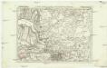
Carte particuliere des environs d'Anvers
1 : 163000 Antverpy (Belgie) Covens & Mortier

Tabula Castelli ad Sandflitam, qua Simul inundati agri, alluviones, Foßae, alvei, quae Bergas ad Zomam et Antverpiam interiacent, annotantur. [Karte], in: Novus atlas absolutissimus, Bd. 3, S. 61.
1 Karte aus Atlas Janssonius Offizin
De Schelde van Antwerpen tot Bath
1 : 90000 steendr. v. C. Magnenat Amsterdam : Frans Buffa & Zonen [...]
Tabula Castelli ad Sandflitam, qua simul inundati agri, alluviones, foßae, alvei, quae Bergas ad Zomam et Antverpiam interiacent, annotantur. [Karte], in: Theatrum orbis terrarum, sive, Atlas novus, Bd. 1, S. 348.
1 Karte aus Atlas Blaeu, Joan Blaeu, Willem Janszoon
Carte particuliere des Environs de Lier et d'une Partie de la Campine
1 : 116600 Mollova mapová sbírka Fricx, Eugène Henry Fricx, Eugené Henry
TABVLA | Castelli ad Sandflitam, | qua simul inundati agri, | alluviones, fossæ, alvei, | quæ Bergas ad Zomam | et Antverpiam interjacent, | annotantur.
Excudit | Guiljelmus Blaeuw.
Tabula Castelli ad Sandflitam, qua simul inundati agri, alluviones, foßae, alvei, quae Bergas ad Zomam et Antverpiam interjacent, annotantur. [Karte], in: Novus Atlas, das ist, Weltbeschreibung, Bd. 1, S. 330.
1 Karte aus Atlas Blaeu, Joan Blaeu, Willem Janszoon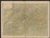
Tabula Castelli ad Sandflitam, qua simul inundati agri, alluviones, foẞae, alvei, quae Bergas ad Zomam et Antverpiam interiacent, annotantur. [Karte], in: Gerardi Mercatoris et I. Hondii Newer Atlas, oder, Grosses Weltbuch, Bd. 1, S. 381.
1 Karte aus Atlas Mercator, Gerhard und Hondius, Jodocus Jansson, Jan
Carte particuliere des environs de Lier et d'une partie de la Campine
1 : 110000 Belgie Fricx, Eugene Henry chez Eugene Henry Friex